{Click on any image to view full size, then use the back button on your browser to return to this page}
This page last updated on 10/20/2019
 |
| (Fig. 01) |
Directions: Inyo Mine Camp is located off Highway 190 in the central section of Death Valley National Park, about 2-1/2 hours northwest of Las Vegas. Echo Canyon Road is about 155 miles from Las Vegas. From Henderson drive out toward Death Valley. Take NV-160 out of town to Pahrump. There is a sign for Death Valley Park at Bell Vista Rd. Turn left at Bell Vista Rd and drive due west toward Death Valley Junction. At the California border the road turns into State Line Road. Turn right at Death Valley Junction onto and then a sharp left onto Highway 127 and then and a sharp left onto 190. Driving west and then north toward the Furnace Creek Visitor Center. About 3.5 miles before the Furnace Creek Visitor Center, turn right onto a dirt road that has a sign for Echo Canyon Road. Follow this dirt road northeast across the bajada heading toward Echo Canyon and the Funeral Mountains Wilderness Area, where 4WD likely is required. At an intersection about 9 miles out, stay to the right for another 0.5 miles to the Inyo Mine Camp. There is a parking area looking at the mill of the camp (Fig. 01). The camp is adjacent to the road, and the actual mines are up the hill. Echo Canyon Road is closed about 0.2 miles farther up the canyon.
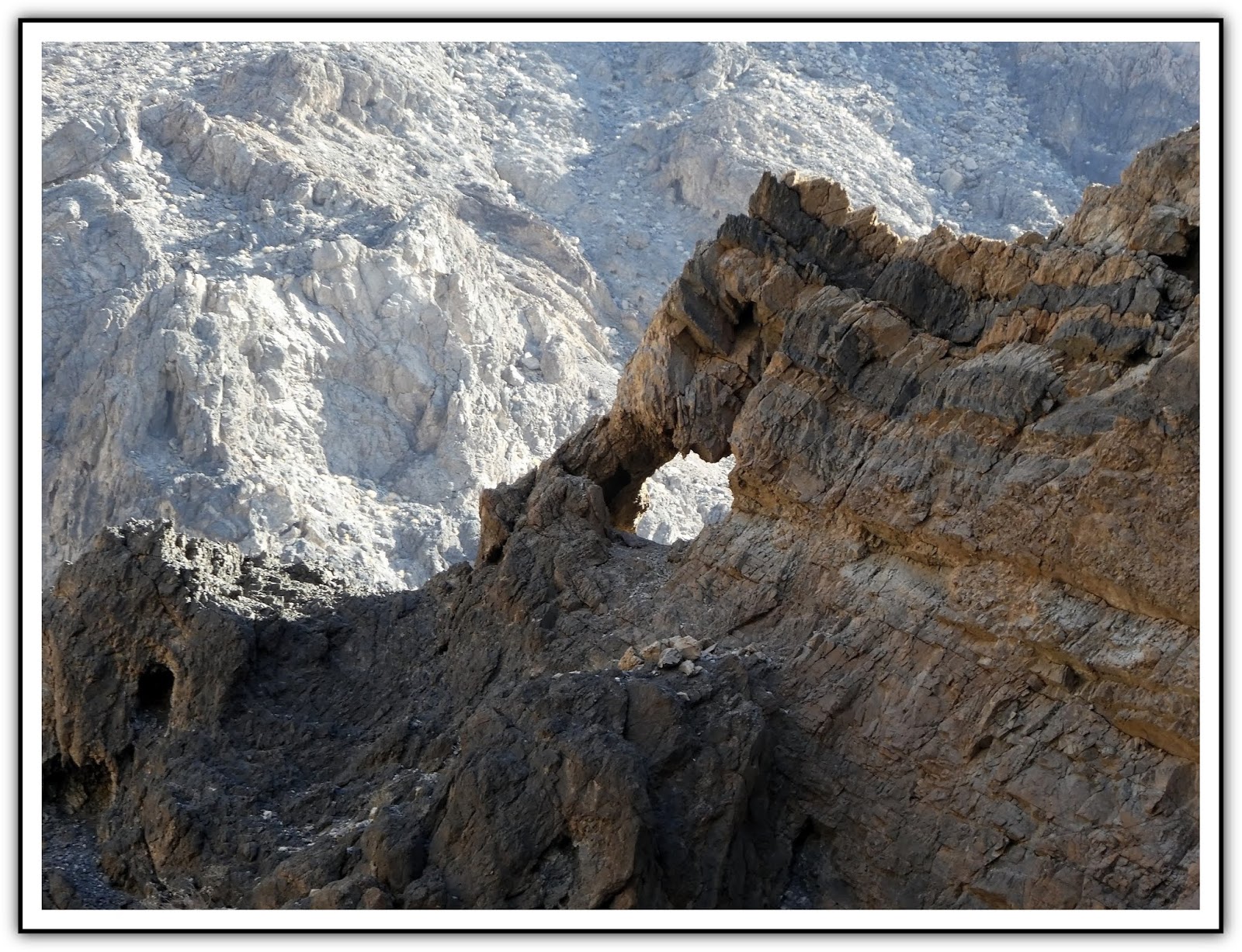
Overview of Echo Canyon Road: Echo Canyon Road is a gravel two-track, 2WD-HC road with a firm base that runs up a broad wash, through a long narrow canyon, and then up the broad wash beyond. The road passes Needle's Eye Arch and eventually about 10 miles out comes to the Inyo Mine Camp. From the pavement, the road runs northeast along the base of a low hill, then continues northeast across the broad, open bajada towards the mouth of Echo Canyon in the distance (Figs. 02 & 03). At about 3.4 miles out, the road enters the narrows of Echo Canyon (Fig. 04). The canyon is fairly narrow in places, and the road constantly winds back and forth providing views looking up of nearly 1000 feet (Figs. 05 & 06). We can't say how much we enjoyed the drive through Echo Canyon. It is truly spectacular. At 4.8 miles out, it reaches the Needle's Eye Arch, which is a hole in a thin fin of rock that juts out into the canyon forming a tight gooseneck turn (Fig. 07). Technically, the Needle's Eye Arch is an arch, but it looks more like a hole through the rock fin. We called it the Arrowhead Arch. As such, the road winds around to the other side of the Eye (4.9 miles out) before continuing up the canyon (Fig. 08). We spotted some barrel cactus high up on the cliffs (Fig. 09). There are plenty of views of colorful cliffs and washes leading into the canyon (Fig. 12) The canyon remains narrow until about 5.5 miles out, when it passes through a tight spot and opens into a relatively broad wash. Continuing on Echo Canyon Road, at about 9.5 miles out, the road arrives at the Inyo Mine Camp parking area on the left. A small sign reads: "Inyo Mine," and several buildings can be seen beyond. Higher on the hillside, mine tailings and additional structures can also be seen.
 |
| (Fig. 02) |
 |
| (Fig. 03) |
 |
| (Fig. 04) |
 |
| (Fig. 05) |
 |
| (Fig. 06) |
 |
| (Fig. 07) |
 |
| (Fig. 08) Back side of thee Needles Arch |
 |
| (Fig. 09) Barrel Cactus growing high on a cliff |
 |
| (Fig. 10) |
 |
| (Fig. 11) One of many washes leading into Echo Canyon |
Inyo Mine Background and History: In January 1905, two prospectors, Maroni Hicks and Chet Leavitt, discovered rich gold-bearing quartz veins in Echo Canyon while chasing their pack animals. In the next two years dozen of claims were established in Echo Canyon. Inyo was the largest in what became the Echo-Lee mining district. By May they had staked 20 claims in the area, and were ready to sell. Finally, in December of 1905, a sale was made. L. Holbrook and associates, a group of Utah mining promoters, purchased the entire mine and incorporated the Inyo Gold Mining Company. Maroni Hicks accepted cash for his half of the mine, but Chet Leavitt retained his interests and became the vice president of the new company. The Inyo Gold was incorporated in Utah, with a capitalization of $1,000,000, based upon 1,000,000 shares of stock with a par value of $1 each. The new company owned twenty-one claims, which represented all of the Hicks & Leavitt properties, including those which had formerly been bonded to Charles Schwab. Soon after the incorporation of the new company, development work in the mine began, and in early January of 1906, the property was surveyed. The long and short of it is that there was no water and the investment monies ran out. (see the Inyo Mine History Continued at the bottom of this page)
10/17/2019 Trip Notes: Today Jim Herring, Bob Croke and Ron Ziance drove to Death Valley to look for the Inyo Mine Camp. It should be noted that the mine camp and mines are not actually in the boundary of the National Death Park. Read the
Overview of the Echo Canyon Road notes above for a description of the trip to the camp. On the way to the Inyo camp we stopped at what I believe was the Charles Schwab Mine camp and site (Figs 12 thru 15). Once we got to the Inyo Mine Camp site we decided to have lunch. The building is on the right in (Fig. 16). We ate in what was once the bunk house (Figs. 17 & 18). (see Trip notes continued below)
 |
| (Fig. 12) |
 |
| (Fig. 13) |
 |
| (Fig. 14) |
 |
| (Fig. 15) |
 |
| (Fig. 16) "Bunk" house where we had lunch is on the right |
 |
| (Fig. 17) |
 |
| (Fig. 18) The "Bunk" house where we had lunch |
 |
| (Fig. 19) The house on the left in (Fig. 16). We surmised that this might be where the mine owner may have lived. |
 |
| (Fig. 20) The extension on the back of the house may have been a bathroom. |
Trip Notes Continued: Due to the relatively recent dates, between 1930 and 1940, the last attempts to exploit the Inyo Mine, historic structures at the property are quite extensive, though they are rapidly deteriorating. The view in the picture (Fig. A) is looking toward the mill. The two large buildings were probably the kitchen and the large dining hall. Both are just two piles of lumber (Fig. 22). You can see the main mine complex of the Inyo Mine, high on the hillside behind the mill and camp buildings. Refer to the side note, Main Mine Complex below. The view in the picture (Fig. B) shows the mill and the two collapsed buildings in (Fig. 22) and the previous building in (Figs 19 & 20). (Notes continued below)
 |
| (Fig. A) The Inyo Mine complex in 1973, as viewed from the lower Echo Canyon road. The mill buildings have been salvaged, although the skeletal remains of the mill are still standing. The cookhouse, which has deteriorated considerably, is seen at the far right, and the ore bin of the main mine complex is seen in the top center of the photo. The complex looked much the same in 1978. Photo courtesy of Bill Fiero, Las Vegas, Nevada. The mill is on the left and today the two large buildings on the right have now collapsed (Fig. 22). Much of the damage was due to natural elements, but portions of the siding lumber was been stripped for use as firewood by the complex's occasional visitors. Up on the hill in the center of the picture is the main mine complex of the Inyo Mine |
 |
| (Fig. B) Viewed from just east of the building in (Fig. 19) looking towards the mill. The Inyo Mine complex, ca. 1938, during the active period of the Inyo Consolidated Mining Company. The structure in the middle with the smokestack is the cook house, and the mill complex is shown to its right. The mining area is far above the mill, to the rear of the photographer. Photo courtesy Death Valley National Monument Library, Negative #1100. |
Side Note - Main Mine Complex: Above the mill and living area is the main mine complex of the Inyo Mine. I tried driving there, but the road was too tough and had to turn around. If you could get here you would find a stone powder house, another tent platform site, a fairly substantial ore bin, a collapsed wooden building, and a whole array of shaft and tunnel entrances running up and down the hillside. The ore bin has a tramway track leading into one of the adits, and a straight-six gasoline powered engine, adapted from a vehicle of some sort, which was used to hoist the ore. Above this group is yet another complex of mine workings, which appears to be older than the first. This area includes another timbered ad-it, a tramway track, a leveled tent site, a small ore bin, and a crude ore chute leading down to a rickety loading bin. Close by is yet another shaft, with a winch left over from the ore hoisting days. I was very disappointed that I couldn't get there.
Trip Notes Continued: The building in (Figs. 19 & 20) was just to the left of the building where we ate lunch. This was a well built house and even had a layer of clapboards. The addition at the rear in (Fig. 20) may have been a bathroom. At the mill site are the remains of the ball mill and its supporting machinery (Fig. 21), and a complex of living and support buildings (Fig 22). The mill ruins consist of the ore bin and chute, a jaw crusher and the settling plates--the ball mill apparatus itself has been removed (Fig. 23). In addition a large metal tank and the old diesel engine which powered the mill still remain (Figs. 24 & 25). Around the mill is a complex of structures in various degrees of deterioration, including five tent platform sites, some with wooden floors and remnants of canvas, a collapsed wooden frame building (Fig. 27), and six standing wood buildings, ranging in size from a twelve by twelve shed to an eighteen by thirty foot cooking kitchen and dining house. Most of these buildings are quite crude, being constructed of wood plank floors, with unfinished walls and ceilings, but the cookhouse, at least, had a cement floor and was equipped with plumbing. Unfortunately most of these have deteriorated due to age and natural weather conditions (Figs. 26 thru 29) Although it is not possible to be certain, some of these buildings, especially the tent platforms and one old dugout in the midst of this complex undoubtedly date from the 1907 era of mining (Fig. 30). But the adaptation and use of different structures and materials during the later period of mining makes a differentiation between the two eras hard to determine. We have all agreed that this site is probably one of the largest we have ever seen. It is hard to imagine how difficult it was to get everything they needed to survive here. Water had to be hauled from Furnace Creek, a distance of eight miles. Food and supplies to feed a workforce of 30 people during the peak seasons. Not to discount the fact that there could be no work during the summers due to the extreme temperatures. On our way back down Echo Canyon, Jim spotted yet another arch (Fig. 29).
 |
| (Fig. 21) Ore bin chute and jaw crusher |
 |
| (Fig. 22) Two large buildings in the foreground that have collapsed |
 |
| (Fig. 23) |
 |
| (Fig. 24) |
 |
| (Fig. 25) Old diesel engine that powered the mill |
 |
| (Fig. 26) Dugout cabin |
 |
| (Fig. 27) Another collapsed structure |
 |
| (Fig. 28) Still Standing Cabin |
 |
| (Fig. 29) "Stuff" from around the site that other visitors hand gathered and placed on a wooden table |
 |
| (Fig. 30) Interior of the Dugout cabin |
 |
| (Fig. 29) |
Inyo Mine History Continued: In 1906, by the first of February the shaft on the Inyo Mine was down to sixty-five feet, and that depth had been increased to 100 feet by March. At that time, nine men were employed at the mine, under the direction of Chef Leavitt, who was general manager of the company. By the end of April, crosscuts were going out from the 20-foot level of the shaft in the search for ore, and a second shaft was started on another claim. In June the Rhyolite Herald reported "The Inyo Gold Mining Company has made the most phenomenal strike in the history of Funeral Range mining and one of the biggest uncoverings since the discovery of Tonopah Assays from the new strike, which was at the bottom of the new shaft at a depth of sixty-five feet, were close to $300 per ton."But work progressed more slowly than the company had hoped, and no shipments were made in 1906, although the company had its new shaft down to seventy-three feet by the end of that year, and several crosscuts were started. But as 1907 opened, work began in earnest on the Inyo Gold. The company ordered a small gas hoist in early January of that year, and by the end of that month reported that it had three shafts exploring for ore at depths of 100, 73 and 30 feet, respectively. In addition, tunnels and crosscuts were being driven, and ore bodies were being found, although the estimated extent and content of the ore finds were not greatly publicized. At peak seasons the company employed around 30 miners to work the shafts.
The camp below the mines boasted in the spring of 1907 a boarding house, sleeping quarters and several tents, a blacksmith shop, and a store selling groceries and mining supplies. The ore was free milling, which meant that it could be treated in the simplest manner, and once the Ash Meadows Water company had completed its pipe line into the Lee district, the company was considering the construction of a mill. Water was now hauled from Furnace Creek, a distance of eight miles, at considerable expense to the company. The boarding house at the mine was feeding thirty miners at one time. Since that overcrowded its accommodations, a new boarding house with an eighteen by thirty foot dining room and a fourteen by sixteen foot kitchen was being built. When it was finished the present boarding house would be converted into a rooming house. In addition, the company was building a sixteen by twenty foot commissary for the sale of groceries and mining supplies to the company's employees and other prospectors in the area. Though production began in the winter of 1906, most of the ore assayed at $300 per ton with some running as high as $650 per ton. By the fall of 1907 the Inyo had three vertical shafts and 755 feet of tunnels hosting equipment, blacksmith shop, boarding house, and a store. Most of the work was done in the winter months when the temperatures were cooler. Though they were running out of money, the company continued operations for a few months. Work was continued during September and October, with a force of between fifteen and twenty miners. But after the middle of October, momentum slowed considerably and very little further work was accomplished for the rest of 1907, although the mine was reported to still be employing a "small force of men" at the end of the year.
There was good ore in the ground, but the problem was transporting it without first milling it. The main problem was a lack of water to operate the mill, and the company was expecting a nearby water company to bring water close enough to where it would be profitable to build a mill. Because of this no ore was shipped in 1906. Around April 1907 the Inyo Gold company announced it would begin construction of a mill and begin shipping ore upon its completion. But the company had waited too long. In September, the funds advanced by the owning partners ran out, and the company's debt reached over $15,000 and its treasury emptied. To sell a large number of remaining shares, the company decided to go public, right as the great financial panic of 1907 occurred. It faced a depressed market and unavoidable bankruptcy, and mining ceased in December of that year. In the fall of 1907 attempts were made to raise money through a public stock sale but 1907 was also a year of financial panic throughout the west. In 1912 the owners tried and failed again. In January of 1912 the Inyo was finally abandoned, without even shipping a single ton of ore.
From 1907 through 1927 very little work was done and in 1928 the mine was sold. The new owners found themselves victims of the mines earlier difficulties, gold was in the ground, but was costly to extract and water wasn't available for milling. Little was done until 1937 when the mine was leased to the Inyo Consolidated Mining Company. The company then installed a ball crushing mill with a 25 ton a day capacity and began hauling water from Furnace Creek, 8 miles away, and had plans for a pipeline. In February of 1939, Mrs. Gilbert again leased the mine, to an unnamed individual, who almost immediately found a rich ore shoot at the bottom of one of the shafts. Before the press coverage of this phenomenon ceased, the lessee had sipped thirty-six tons of ore worth $280 per ton to the smelter, for a gross profit of $10,080, and had hired several miners. But once again, the ore shoot ran out, and the lessee was soon out of business. In February of 1939, Mrs. Gilbert again leased the mine, to an unnamed individual, who almost immediately found a rich ore shoot at the bottom of one of the shafts. Before the press coverage of this phenomenon ceased, the lessee had sipped thirty-six tons of ore worth $280 per ton to the smelter, for a gross profit of $10,080, and had hired several miners. But once again, the ore shoot ran out, and the lessee was soon out of business. By the spring of 1938 the mine closed due to the lack of water.
The mines lay idle for 23 years, until 1935-36 when the Inyo Consolidated Mining Company leased the claims from a new owner and began working the old tunnels. It revived the camp and installed a 25-ton ball mill and a small amalgamation and concentration plant, run by water brought from Furnace Creek. The company mined and milled ore averaging $25 a ton until lack of funds forced it to close again in 1938. The mine was leased again in 1939 and produced gold at $230 per ton, but the deposit ran out. The last shot was in 1940 with the same results and then closed for good. Other small enterprises continued to try their luck at the mines,some with moderate success, but by 1941 the mines closed down for good.
Reference: This info (including the two pictures in Figs. A & B) was taken from the pages of ... Death Valley - Historic Resource Study - A History of Mining - B. The Funeral Range - 7. Echo Canyon at - https://www.nps.gov/parkhistory/online_books/deva/section4b7.htm
___________________________________________________
Note: Every attempt is made to provide accurate information, but occasionally depictions are inaccurate by error of mapping, navigation or cataloging. The information on this site is provided without any warranty, express or implied, and is for informational and historical purposes only.