{Click on any image to view full size, then use the back button on your browser to return to this page}
This page last updated on 06/19/2019
 |
| (Fig. 01) |
Directions: From Las Vegas, follow US-95 North for approximately 104 miles (approximately 10 miles south of Beatty, Nevada). Turn right onto an unmarked dirt road on the right side of the highway (heading northeast) (Fig. 01). You can see some visible ruins from the highway. This road runs almost straight up the desert valley to the base of Bare Mountain and the old Carrara marble mine site, refer to (Fig. 02).
 |
| (Fig. 02) |
 |
| (Fig. 03) |
Description of Area: From highway 95 there is a relatively flat desert baja that stretches to the base of the Bare Mountains. A rough dirt road stretches about three miles up to the location of the marble quarry itself. Mill foundations are found near the highway, while the Carrara townsite is located about a quarter mile east of the highway. About a quarter mile out there is the visible remains of a chimney (Fig. 03). The chimney was of the hotel. This spot was the approximate location of the down of Carrara. Though it once enjoyed several years’ worth of hustle and bustle in the mid-teens and early 20s, the town's only remains today are a few cellars, slabs, building foundations (Figs. 05-07). In the old picture of the town, there is a building in the very center that appears to have a chimney, possibly the one in picture (05), The town's main attraction was a marble fountain that was 18 feet across, and 3 feet deep that supported a 6 foot column of water. The pictures in (Figs. 08-10) even shows some of the pipe that provided water to the fountain. The old picture in (Fig. 11) shows two unknown persons sitting on the edge of the fountain. The fountain got its water from a nine mile pipeline that ran down from the town of Gold Center to the northwest.
 |
| (Fig. 04) Click to Enlarge |
|
 |
| (Fig. 05) Click to Enlarge |
|
 |
| (Fig. 06) Click to Enlarge |
|
 |
| (Fig. 07) |
 |
| (Fig. 08) Click to Enlarge |
|
 |
| (Fig. 09) Click to Enlarge |
|
 |
| (Fig. 10) Click to Enlarge |
|
 |
| (Fig. 11) |
Town Background and History: May 8, 1913 brought about a grand dedication of the townsite, complete with a ball, music by a band brought down from Goldfield, baseball game, swimming in the town pool. A newspaper, the Carrara Obelisk, was published (published May 8, 1913 - September 1916), and the post office opened shortly after (May 24, 1913 - September 15, 1924). A hotel, store and restaurant also served the town. Due to the completion of the mines’ railroad in 1914, Carrara’s peak years were 1915 and 1916. Some buildings were actually moved to Carrara from Beatty and Rhyolite to make the town look more finished than it really was. Circa 1914, a hotel was opened that featured electric lights, running water, and telephones, along with a store and restaurant. Around this time, there were more than forty buildings at the town site, which eventually inflated to about 100 residents. It even had a newspaper, the Carrara Obelisk, which published between May 8, 1913 and September 1916, and a post office that was opened shortly thereafter on May 24, 1913. The post office remained open until September 15, 1924. Unusual for the desert, Carrara could even boast its own town fountain. Water came from near the site of Gold Center, a few miles across the valley.
Quarry Background and History: Though some records indicate that the marble deposits were first located in 1904, it wasn't until 1911 that some prospectors ended up forming the American Carrara Marble Company. The economy of Carrara was based almost entirely on the marble quarry (Figs. 12-13). Because the Las Vegas & Tonopah Railroad was three miles below the mine site, a three mile unpowered cantilevered railroad that involved a single standard gauge track upon wooden ties was built to get the marble blocks, sometimes weighing up to fifteen tons, down for shipping. Motor power was a full car that pulled the empty one up the hill. At the midway point, a turnout track allowed the cars to pass each other. Begun in 1913, it was completed in 1914. After the marble slabs were processed, they were shipped out over the Las Vegas & Tonopah until that company failed. Later, the nearby Tonopah & Tidewater Railroad built a spur to the marble mill at Carrara and thereafter shipped out tonnage. After the failure of the marble quarry, the owner tried to build a cement plant. Concrete structures a mile and a half north are of a 1930's failed cement plant. Sometimes referred to as the Elizalde Cement Plant ruins, the shell of this abandoned complex was officially called the Carrara Portland Cement Company Plant. Carrara Portland Cement Company was incorporated in November of 1940. It was slated to produce two grades of cement: gray construction cement, and a high quality white cement using the crushed white Carrara marble from the nearby quarry. Production was estimated to be at about 80 tons a day once the plant was completed, sometime in August 1941. Unfortunately, a fire in July 1941 swept through the complex destroying numerous buildings. Despite all of the time, money and effort invested, the cement plant was never put into operation.
 |
| (Fig. 12) Click to Enlarge |
|
 |
| (Fig. 13) Click to Enlarge |
| |
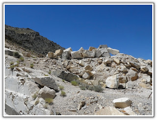
Trip Notes: I visited this place three times. The first two times were in 2013 with Harvey Smith when we visited the quarry processing site near the road (Figs. 14-16 below) and the area of the original town site (figs. 03-10 above). Refer to (Fig. 01). The last time was on 19 June 2019 with Jim Herring, Bob Croke and Ron Ziance when we drove out to the site of the marble quarry and the mine of the cement mine. On today's visit, driving up the rock, rocky road leading to the marple quarry proved to be much more difficult than I expected. It became so rough and washed out about 3/4 of the way out, we had to park the jeep and hike the remaining distance to the mine and the quarry. At a point the road kind of split. Going left led to the mine up on the north side of the canyon (Fig. 20). Bob and Ron took this route which turned out to be a higher climb and a little more difficult. Jim and I followed what appeared to be the old road that ended up at the site of the marble quarry (Figs. 21-23). Off to the side of the relatively deep quarry pit, there was a large pile of unused pieces piled up (Figs. 24 & 25). Though it was still a pretty rough road, it was easier than the route that Bob and Ron hiked. The hiking made the trip more difficult than we had expected, but finally seeing the quarry made the trip worth it. However, on the way back, the rough road caused me to tear off the right front wheel flare molding (Fig. 26).
 |
| (Fig. 14) Click to Enlarge |
|
 |
| (Fig. 15) Click to Enlarge |
|
 |
| (Fig. 16) Click to Enlarge |
|
 |
| (Fig. 17) Click to Enlarge |
|
 |
| (Fig. 18) Click to Enlarge |
|
 |
| (Fig. 19) Click to Enlarge |
|
 |
| (Fig. 20) |
 |
| (Fig. 21) Click to Enlarge |
|
 |
| (Fig. 22) Click to Enlarge |
|
 |
| (Fig. 23) Click to Enlarge |
|
 |
| (Fig. 24) Click to Enlarge |
|
 |
| (Fig. 25) Click to Enlarge |
|
|
 |
| (Fig. 26) |
___________________________________________________
Note: Every attempt is made to provide accurate information, but occasionally depictions are inaccurate by error of mapping, navigation or cataloging. The information on this site is provided without any warranty, express or implied, and is for informational and historical purposes only.


