Tuesday

Daytrip - Gold Point NV


Click to enlarge
On 11/15/2018 Bob Croke and I went to Gold Point, Nevada, located at the southern portion of the large, relatively flat Lida Valley in Esmeralda County. At an elevation of 5,368 feet in the desert, this old ghost town is a living history lesson with about 50 buildings still standing, There are dozens of abandoned mines scattered all over the place just beckoning for exploration. It is truly a photographers dream. Click here for pictures and a description ... Gold Point Nevada.

Daytrip - Petrified Logs at Valley of Fire State Park

On 11/10/2018, Ron Ziance, Bob Croke and myself joined about 12-14 others for a guided tour of an area of petrified logs that is off limits to the general public. After we left the meetup area we hiked above a long wash before descending down into the wash itself. Eventually we came to a locked gated along the fence that surrounded the area. Once inside we walked around and climbed a hillside that was just loaded with thousands of pieces of varying sizes of petrified wood. Click here for pictures and a description of this hike ... Petrified Logs at Valley of Fire State Park.

Wednesday

Daytrip - Three Mines and Mt Potosi Microwave Towers

Click to Enlarge
On 11/03/2018, Jim Herring, Bob Croke, Harvey Smith and I took a trip to the area behind the town of Goodsprings. We visited an unknown mine, the Red Cloud Mine & Mill site, Pilgrim Mine and the Lower Potosi Microwave Towers. The drive up to Lower Potosi proved to be quite interesting. We found a half dozen people jumping off the side of the mountain with paragliders: lightweight, free-flying, foot-launched glider aircraft with no rigid primary structure.  Here are links to pages I created for each of these sites: Unknown Mine, Red Cloud Mine & MillPilgrim Mine, and the Microwave Towers on Lower Potosi Mountain. Each page is filled with pictures and descriptions of the day's adventure. Be sure to click on each of these individual links.

Friday

Daytrip - Table Mountain Range

On 10/17/2018 Jim Herring, Harvey Smith and i drove to the area of Goodsprings to take a trip to the top of Table Mountain. Off Sandy Valley Road, a road that follows along an area that is known as the Columbia Pass, between the southern end of the Spring Mountain range to the north and the Table Mountain range to the south, on its way towards the town of Sandy Valley there is a rough 4WD road that leads to the top of Table Mountain. This road and its branches also lead to several old mines. Click here for pictures and a description of this adventure ... Table Mountain Range.

Daytrip - Carroll Shelby Museum

On 10/12/2018 Ron Ziane and I visited the Carroll Shelby Museum located adjacent to Interstate 15 and just a few blocks from Las Vegas Boulevard. The museum consists of a 100,000 square foot manufacturing facility where the Cobras and the new Series 1 are being constructed. There is a showroom filled with 35 years’ worth of Shelby performance cars, many worth upwards of 1 million dollars. The museum is open Monday thru Friday 8:00am to 5:00pm and offers free tours of the museum and production facility daily at 10:30am. Click here for pictures and a description of this trip ... Carroll Shelby Museum.

Thursday

Crystal Pass (Prospect) Mine - Goodsprings Mining District

{Click on any image to view full size, then use the back button on your browser to return to this page}
This page last updated on 12/03/2018
(Fig. 01)
(Fig. 02)
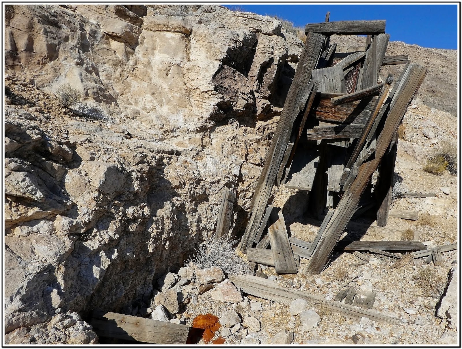
(Fig. 03) Click to Enlarge
Directions: Leaving from the Stratosphere, get on the I-15 South. Go 24 miles and take NV-161 (Exit 12) toward Jean/Goodsprings. Leaving Jean, head west on Route 161 towards Goodsprings. Continue through Ivanpah Valley on the left and Goodsprings Valley on the right, until you reach a dirt road on the left about a half mile before Sandy Valley Road. You will be able to see the the Goodsprings Energy Recovery Station on the left. Turn left onto the unmarked dirt road and follow this road to the Crystal Pass (Prospect) Mine site (Fig. 01) as indicated on the map in (Fig. 02). The picture in (Fig. 03) on the right is an overhead view looking down onto the site from above.

Area Description: For a more detailed description of the Goodsprings Mining District, go to my page titled, Goodsprings Mining District (South). There are literally dozens of prospects, mines, shafts and adits in the Goodsprings' Mining District in the southern end of the Spring Mountain Range south of the town. The majority of these are accessed from two 4WD roads that run off of Sandy Valley Road and Nevada 161. Table Mountain Road which runs south off of Sandy Valley Road, provides access to, among others, the Surprise, Columbia, Argentena, Lookout and Mountain Top mines.  An unnamed 4WD road opposite the Goodsprings Bypass Road on Nevada 161 runs south through the Goodsprings and Ivanpah valleys', and provides access to the Crystal Pass Mine, Lincoln, Ireland, Houghton, Star, Monte Cristo, Portor, Accident, Bullion and Valentine mines, as well as dozens more prospects, adits and unnamed mines. The vast majority of the mines in this portion of the Goodsprings Mining District are in the mountains west of Porter Wash as seen in the (Fig. A) below.

Crystal Pass (Prospect) Mine Description: This mine is located in the northern portion of the Goodsprings Mining District [see Goodsprings Mining District - Summary Page]. The reason that I found it so difficult to find any information on this site is because it was only registered as a prospect, and not as a mine. The prospect shows signs of mineral deposits, but was never advanced to an actual mining site. Though the primary mining in this area included: copper, lead, silver, gold and zinc, the primary products of this mine are listed as silver and lead. When I first visited this site back in 2013 with Harvey Smith, we were surprised at the structures, many levels and depth of this mine. From what we've been able to survey, there were three levels to this mine. One up and one down. There isn't much to see on any of the three levels except for the small gauge rails in the last opening on the upper level used to cart the ores out. Refer to the pictures in the "09/16/2013 Trip Notes" below. Refer to the "12/01/2018 Trip Notes" for an update of this mine.

12/01/2018 Trip NotesOn this visit, Jim Herring and I visited the mine to do some more exploring. After driving to the site and climbing up to the upper levels, we were extremely disappointed. Sadly, in late 2015 the BLM saw fit to close every entrance thereby sealing the mine forever. Using a foam and boulders they blocked every opening. Other than the pictures of my first visit in the section below, no new images of the interior will ever become available again. We spent some time touring the site and documenting what the BLM had done (Figs. 04 thru 06). Due to the elevation of this mine, roughly 3,860 feet, there are some outstanding views of the surrounding area (Figs. 07 & 08). Looking southwest from this site we spotted what looked like another mine in the wash below that leads to the ridge of Crystal Pass (Fig. 09). Refer to the spot listed as "Mine Shaft" on the map in (Fig. 02). The shaft of this mine was fenced off with barbed wire. After "hopping" the fence pictures indicated that it was quite deep (Figs. 10 thru 12). From here we drove south to the Lincoln Mine noted on (Fig. 02).

(Fig. 04)
(Fig. 05)
(Fig. 06)
(Fig. 07)
(Fig. 08)
(Fig. 09)

(Fig. 10)
(Fig. 11)
(Fig. 12)
09/06/2013 Trip Notes: Today we spent over 6 hours driving around this area locating, hiking and exploring a handful of the many mines located in this region. Towards the end of the day, we finally reached the area in (Fig. A below) and it's many mine sites, the majority of which required strenuous hikes, 400-500 feet up mountainsides in order to reach them. Because our time appeared limited due to impending storms, we surveyed the landscape and picked out one of the largest, the Bullion Mine, and headed in its direction. Even if we spent another full day here, we still wouldn't have enough time to adequately explore all of the many mines located here.

(Fig. A)
Notes on (Crystal Pass Mine): About 2-1/2 miles in from NV-161 we made two right turns (Fig. 02) that led us up a wash (Fig. 13) towards a saddle known as Crystal Pass and the large mine site of Crystal Pass (Prospect) Mine (Figs. 03 & 13) located three-quarters of the way up the mountain on the east side of the wash. As it turned out, this mine, now a total of about 4 miles out, turned out to be the find of the day. From its lower opening (Fig. 14) (elv 3,754 feet), it tunneled upwards 125 feet along the ridge-line to a final elevation of about 3,875 feet. Shortly after entering the lower tunnel (Fig. 15), I observed sunlight coming from the roof of the tunnel up ahead (Fig. 16). Shortly, I was able to look skyward through an opening (Fig. 17) that appeared to have been the result of a cave in many years ago. As we worked our way through the various tunnels, we found no less than three side shafts that led to the outer edge of the ridge. It appeared that these may have been created to make it easier to get the ore and excess materials out of the tunneling operations. The last two tunnel sections still had the remains of some small gauge ore cart rails (Figs. 18, 19 & 20). When we reached the end of the longest tunnel it split into two separate tunnels (Fig. 21); The one to the right was rather short, so Harvey decided to venture a short distance into the one on the left. After scaring up a few bats that flew by us at amazing speed and out the opening (Fig. 22) behind us, we decided it was time to leave.  Because this final opening was so high, we were unable to exit the mine here and had to backtrack until we were able to find another ground level opening (Figs. 23 & 24). The view in (Fig. 25) is looking south from the main entrance. Located to the southeast of Primm, notice the dry Ivanpah lake-bed in the distance. Considering the extensive operation that went on here, I am surprised that it was never filed as a mine.
                            

EFP-P1030434
(Fig. 13)

EFP-P1030450
(Fig. 14)

EP-P1030451
(Fig. 15)
EP-P1030460
(Fig. 16)
EP-P1030452
(Fig. 17)

EP-P1030488
(Fig. 18)
EP-P1030477
(Fig. 19)
EP-P1030483
(Fig. 20)

EP-P1030479
(Fig. 21)
EP-P1030478
(Fig. 22)

EP-P1030489
(Fig. 23)
EP-P1030491
(Fig. 24)

EFP-P1030462
(Fig. 25)
For additional pages on mines around the Goodsprings Mining District also visit the following ... 
Note: Every attempt is made to provide accurate information, but occasionally depictions are inaccurate by error of mapping, navigation or cataloging. The information on this site is provided without any warranty, express or implied, and is for informational and historical purposes only.

Lincoln Mine - Goodsprings Mining District

{Click on any image to view full size, then use the back button on your browser to return to this page}
This page last updated on 12/03/2018
(Fig. 01)
Directions: Leaving from the Stratosphere, get on the I-15 South. Go 24 miles and take NV-161 (Exit 12) toward Jean/Goodsprings. Leaving Jean, head west on Route 161 towards Goodsprings. Continue through Ivanpah Valley on the left and Goodsprings Valley on the right, until you reach a unnamed 4WD road opposite the Goodsprings Bypass Road on Nevada 161, about a half mile before Sandy Valley Road. Turn left onto this road. Refer to (Fig. 02). You will be able to see the the Goodsprings Energy Recovery Station in the distance.

(Fig. 02)
Area Description: For a more detailed description of the Goodsprings Mining District, go to my page ... Goodsprings Mining District - Summary PageThere are literally dozens of prospects, mines, shafts and adits in the Goodsprings' Mining District in the southern end of the Spring Mountain Range south of the town. The majority of these are accessed from two 4WD roads that run off of Sandy Valley Road and Nevada 161. Table Mountain Road which runs south off of Sandy Valley Road, provides access to, among others, the Surprise, Columbia, Argentena, Lookout and Mountain Top mines.  An unnamed 4WD road opposite the Goodsprings Bypass Road on Nevada 161 runs south through the Goodsprings and Ivanpah Valleys', and provides access to the Crystal Pass Mine, Lincoln, Ireland, Houghton, Star, Monte Cristo, Portor, Accident, Bullion and Valentine mines, as well as dozens more prospects, adits and unnamed mines. The vast majority of the mines in this portion of the Goodsprings Mining District are in the Spring Mountains west of Porter Wash as seen in the (Fig. 03) below.

(Fig. 03
Description of the Lincoln Mine: The Lincoln Mine (Fig. 01), is located on a low ridge adjacent to Ivanpah Valley and before the Porter Wash (Fig. 03). Five of the seven claims found here were located by E.W. Lincoln and others in 1905. Its total production has been estimated around 60 tons of ore. Most of the ore shipped has contained about 12 per cent of copper and 15 ounces of silver to the ton, but one lot of 2,700 pounds shipped by J.A. Egger in 1917, contained 97 ounces of silver to the ton. The principal working is an inclined shaft 350 feet long, which begins with a slope of 16 degrees, but attains a maximum of 35 degrees near the end.

Note: Malachite, a.k.a. Molochites, Green Copper, Mountain and Green Malachite, is the most common secondary mineral found in the oxidized zones of copper deposits. Its color is Bright green, with crystals deeper shades of green, even vary dark to nearly black; green to yellowish green in transmitted light. Not a hard ore, it has a tenacity to be brittle. It is closely related to Azurite, another secondary copper mineral frequently found in the oxidized zones of Copper-bearing ore deposits. Azurite is typically found as tabular to prismatic crystals of a deep "azure blue" color with resplendent vitreous faces and is found throughout Lincoln Mine site (Figs. 04 thru 06).

(Fig. 04)
(Fig. 05)
(Fig. 06)
12/01/2018 Trip NotesAmazing as it seems, the BLM had not yet blocked up this mine. As you can see from (Fig. 07) you could enter a good distance into the mine, even though you had to keep low so as not to bump your head. As you climbed down into the shaft from the opening, almost from the start you begin to encounter a vein of Malachite that the miners appeared to be following. All of the pictures in (Figs. 04 thru 06 above) were found near the front part of the mine. The picture in (Fig. 08) is a shot of Jim taking a picture of me as I was crawling out. If you click on and zoom into (Fig. 09) you can see hundreds of small pieces of the blue-green Malachite scattered around the edges of the opening, The tailings directly in front of the mine (Fig. 10) was also filled with the same (Fig. 13).

(Fig. 07)

l
(Fig. 08)
(Fig. 09)

09/06/2013 Lincoln Mine Notes
:
 Because we didn't have a light, it was impossible to determine how far in the adit (Fig. 11) traveled in. To right of this mine we found a couple of level foundation areas (Fig. 12) that may have been used for platformed miner's tents. Along the sides of the large tailing pile we found the largest pile of Malacite (see NOTE above) that we have ever seen anywhere (Fig. 13).

EFP-P1030525
(Fig. 10)

EP-P1030527
(Fig. 11)
EP-P1030524
(Fig. 12)
EP-P1030537
(Fig. 13)
For additional pages on mines around the Goodsprings Mining District also visit the following ... 
Note: Every attempt is made to provide accurate information, but occasionally depictions are inaccurate by error of mapping, navigation or cataloging. The information on this site is provided without any warranty, express or implied, and is for informational and historical purposes only.

Ireland Mine - Goodsprings Mine District

{Click on any image to view full size, then use the back button on your browser to return to this page}
This page last updated on 12/03/2018
(Fig. 01)

Directions
:
Leaving from the Stratosphere, get on the I-15 South. Go 24 miles and take NV-161 (Exit 12) toward Jean/Goodsprings. Leaving Jean, head west on Route 161 towards Goodsprings. Continue through Ivanpah Valley on the left and Goodsprings Valley on the right, until you reach a unnamed 4WD road opposite the Goodsprings Bypass Road on Nevada 161, about a half mile before Sandy Valley Road. Turn left onto this road. Refer to (Fig. 02). You will be able to see the the Goodsprings Energy Recovery Station in the distance. Keep heading south through the Ivanpah Valley, to a  small, rocky knoll about two miles past the Lincoln Mine. See second map in (Fig. 03).

(Fig. 02)
Area Description: For a more detailed description of the Goodsprings Mining District, go to my page ... Goodsprings Mining District - Summary PageThere are literally dozens of prospects, mines, shafts and adits in the Goodsprings' Mining District in the southern end of the Spring Mountain Range south of the town. The majority of these are accessed from two 4WD roads that run off of Sandy Valley Road and Nevada 161. Table Mountain Road which runs south off of Sandy Valley Road, provides access to, among others, the Surprise, Columbia, Argentena, Lookout and Mountain Top mines.  An unnamed 4WD road opposite the Goodsprings Bypass Road on Nevada 161 runs south through the Goodsprings and Ivanpah Valleys', and provides access to the Crystal Pass Mine, Lincoln, Ireland, Houghton, Star, Monte Cristo, Portor, Accident, Bullion and Valentine mines, as well as dozens more prospects, adits and unnamed mines. The vast majority of the mines in this portion of the Goodsprings Mining District are in the Spring Mountains west of Porter Wash as seen in the (Fig. 03) below.

(Fig. 03)

(Fig. 04) Click to enlarge
Description of the Ireland Mine: The Ireland Mine is a grouping of small prospects, pits, adits, and incline shafts that sit on top of a small, rocky knoll at the mouth of Porter Wash, before the road turns to the right and enters Porter Wash (Fig. 03) and the enlarged cutout of (Fig. 04) right. This large knoll is home to nearly a half-dozen mine sites. All of its mines here appear to have long ago been scoured of any signs of equipment & materials. As with many of the mines in this area, there is little information available that I've been able to find. Within an area scarcely 500 feet in diameter there are 8 shafts and shallow pits, the deepest of which is an incline on the north side of the hill 125 feet deep. The ore shipped from this property has come from small loads of lead, copper, and zinc minerals. According to local reports several carloads of copper-bearing lead ore have been shipped from this site.

12/01/2018 Trip Notes As we approached this rocky knoll we turned right and drove to the north side (Fig. 05). At the end of this short road we parked (Fig. 05) in front of the mine's main opening (Fig. 01). Even though this shaft was barred with heavy steel bars just inside the opening (Fig. 06). The shot in (Fig. 07) was taken peering between the bars. Another nearby tunnel (Fig. 08) allowed one to enter a few feet into it. The pictures in (Figs. 09 and 10) show some nearby wood timbers. The shot in (Fig. 11) is exiting the short tunnel. The view in (Fig. 12) is looking northwest out over the desert in front of these mines. Meanwhile, Jim climbed to some of the pilings higher up on the hillside, but all of them had either been filled or barred. (Con't below)

(Fig. 04)
(Fig. 05)
(Fig. 06)

(Fig. 07)
(Fig. 08)

(Fig. 09)
(Fig. 10)
(Fig. 11)
(Fig. 12)
Notes Continued From here we continued on west into the Porter Wash (refer to Fig. 03). We arrived at an unknown site had what appeared to be the remains of an ore offloading platform (Fig. 13). Due south, opposite was a wash and a hillside that contained several sites of adits with pilings (Fig. 14). Looking west, further up the wash you could see the Accident Mine high on the side of the mountain (Fig. 15). Driving up the wash was not very inviting and we decided to settle for a closeup shot with my 720mm zoom lens (Fig. 16). This mine was located in 1901, Little work was done until 1911, and then again in 1919. The mine has several openings, but most of the ore was produced by the main tunnel. The minerals extracted were gold, silver, copper, lead, and zinc. Lead and zinc were the primarily minerals removed, and the others were beneficial byproducts of the zinc & lead extractions. The main tunnel at this site was actually quite extensive. I wished we had been able to reach it. For more pictures of the site go to ... Accident Mine.

(Fig. 13)
(Fig. 14)
(Fig. 15)
(Fig. 16)

For additional pages on mines around the Goodsprings Mining District also visit the following ... 

Note: Every attempt is made to provide accurate information, but occasionally depictions are inaccurate by error of mapping, navigation or cataloging. The information on this site is provided without any warranty, express or implied, and is for informational and historical purposes only.