Tuesday

Brown-eyed Evening-Primrose (Camissonia claviformis)

(Fig. 01)


Picture Info: The picture in (Fig. 1) was taken during a visit to the Death Valley National Park on 02/23/2016. It was captured along Badwater Road on the way to Badwater Basin.

Description: The Brown-eyed Evening-Primrose (Camissonia claviformis), also known as Browneyes, is an annual forb with basal leaves and a flowering stalk that can grown to a height of 2 feet, though usually shorter. Its leafs are generally basal; generally broad and 1-pinnate, but large terminal leaflet may look like an entire leaf; lateral leaflets much smaller than terminal leaflet. The flowers are white, aging to pink, with a dark brown center. The stigma hangs out beyond the petals. Brown-eyed Evening-Primrose is a common component of desert vegetation communities in washes and other gravelly and rocky soils. So found usually in lower elevations, and canbe found in elevations up to about 6,000 feet. It is common to California (Death Valley), Idado, Utah and New Mexico.

Wednesday

Daytrip - Hiko Spring (Lower) Hike


Having heard about a grouping of petroglyph panels located more than a further mile down the Hiko Canyon Wash, three of us decided to check it out. A heavy rain had cleared much the dense growth, reeds and bushes that had been clogging the Hiko wash on my previous visit, making it extremely difficult to navigate. On this hike, there were many large clumps of reeds that had been uprooted and jammed against the sides of the washes' rocks and canyon walls. Once we found the petroglyphs panels, we were amazed at how many elements were were located there. Click here for pictures and a hike description ... Hiko Spring (Lower) Hike.

Daytrip - Fire Station Loop Trail

On 01/28/2016 Robert Croke, Blake Smith and I drove out to the Red Rock Canyon area to hike around the Red Rock Canyon Campground on Moenkopi Road at the intersection of (NV-159) W. Charleston Blvd. about a mile before reaching Red Rock Park. For today's hike we chose the 3.23 Fire Station Loop Trail, which happened to be the longest and most difficult of the five hikes here. After reaching the summit of the hilltop, elevation 3,892 feet, we were afforded outstanding 360 degree views of the whole area. Click here for pictures and descriptions ... Red Rock Canyon Campground Area Hikes.  

Daytrip - Sloan Canyon National Conservation Area

This past week I hiked with the Rockhounds from the Henderson Senior Center to the Sloan Canyon National Conservation Area in Henderson, south of Las Vegas. The Sloan Canyon Petroglyph Site is one of the most significant cultural resources in Southern Nevada. Archaeologists have recorded 318 rock art panels with approximately 1,200 individual petroglyphs that were created by native cultures ranging from the Archaic to the historic era. Over the past five years, I have visited this site three times and captured more than 100 pictures of petroglyphs and the surrounding area. Click each of the links below to view pictures and descriptions of the area.

Sloan Canyon - Sloan Canyon Petroglyph Gallery - SUMMARY Page
Sloan Canyon - Previous Visits to Sloan Canyon Petroglyph Site 

Sloan Canyon - Petroglyphs at Sloan Canyon National Conservation Area
Sloan Canyon - Description of Sloan Canyon National Conservation Area

Tuesday

Robert Croke and Blake Smith

(Fig. 01)

A portion of the land that boarders the east side of the Floyd Lamb Park is known as the Northwest Equestrian Park. Eventually this area will house 320 acres of first-class equestrian facilities including arenas, trails, horse boarding, and host regional and national events. The tilt-shift picture in (Fig. 01) is a shot of Robert Croke and Blake Smith on the return of our three plus mile around this newly being developed park. 

Monday

Hiko (Lower) Spring Site (Summary Page)

             
 {Click on an image to enlarge, then use the back button to return to this page}
This page last updated on 10/11/2017

(Fig. 01)


Here are a few simple guidelines you can follow that will help to preserve these unique and fragile cultural resources that are part of our heritage. Guidelines for Preserving Rock Art. If you would like to learn more about the Nevada Site Stewardship Program, go to my page ... Nevada Site Stewardship Program (NSSP).


Directions: From the Stratosphere Casino head northeast on Las Vegas Blvd about 3 miles and turn right onto I-515/US-93/US-95 south towards Boulder City. Follow US-93/95 for 17 miles and then merge right onto US-95 South (Veterans Memorial Hwy) toward Searchlight/ Laughlin/Needles and travel for 55.5 miles. Turn left onto NV-163 (Laughlin Hwy) east. Drive.About 8 miles from the US-95 turnoff you will see a Laughlin sign in the desert off to your right. Just beyond this there is a fairly open area where a lot of people go four wheeling. Traveling about two miles beyond this area the road runs straight downhill. At the bottom of this stretch, SLOW DOWN. Just before the guard rails where the road makes a sharp left turn, there is an unmarked exit to the right that turns into a dirt 4WD road. There is also a white cross just in front of the guard rail.

Hike Description: Hiking from where we parked the car, you come to a concrete foundation slab on the north side of the wash. Just a few hundred feet beyond the slab you come to the 'upper' spring petroglyphs. This first group consists of several boulders on the side of a small hill just east of the concrete foundation slab. (refer to the pictures on the previous page). The elevation here is about 1,933 feet.

01/31/2017 Trip Notes: On January 31st Jim Herring, Ron Ziance, Bob Croke and myself made yet another trip to Hiko Spring. For the first time in months, it was a beautiful sunny day near 70 with almost no wind. Though Jim had never been to this site before, Bob, Ron and I visited it a year ago. Besides giving Jim the opportunity to view the great petroglyphs found at this site, we were curious to compare what we found on our visit of a year ago. Click here for pictures and description of this hike ... Hiko Spring Hike - Trip Notes for 01/31/2017.

02/02/2016 Trip Notes: Even though I had heard that a heavy rain had cleared much the dense growth, reeds and bushes that had been clogging the Hiko wash, I was amazed at how much the topography this area had been changed since my last visit. The pictures found in the collage (Fig. 02), show the difference between today (the top two pics) and my visit in 2013 (bottom three pics). The area where we entered the wash on today's visit wasn't even possible back in 2013. Walking down the middle of the wash, there were many large clumps of reeds that had been uprooted and jammed against the sides of the washes' rocks and canyon walls (Fig. 01). As we hiked down the wash, we came upon nearly a half dozen areas (Fig. 03) where flowing water percolated up through the sand, only to disappear back beneath the surface, usually less than a hundred feet later. We can only assume that the water originates from the spring near the beginning of the hike. In addition to the green slime around these water areas, there were several green grassy areas located nearby (Fig. 04). (con't below)

(Fig. 02)
(Fig. 03)
(Fig. 04)
Notes Continued:   In the lower end of the wash a grouping of boulders contain dozens of individual petroglyph elements (Fig. 05). Of the more than 40-50 individual elements, most of these elements were of a very abstract design (Figs. 06 & 07).  I was only able to discern three zoomorphs (possibly bighorn sheep) and maybe two anthroporphs (human-like figures) (Fig. 08). After examining this area we continued to walk down the wash. A few hundred yards further down we encountered another small grouping on the side of a hillside (Figs. 09 & 10). From here we continued to hike some more in the hopes of maybe coming to the end of the wash. Unfortunately, as the wash started to fill with more and more big boulders (Fig. 11), it also started to head downhill much steeper than previously (Fig. 12), and still be getting nowhere near the end. As we later determined we would still have had to continue more than a mile of tough hiking in order to reach the end of the canyon/wash.  

(Fig. 05)
(Fig. 06)
(Fig. 07)
(Fig. 08)
(Fig. 09)
(Fig. 10)
(Fig. 11)
(Fig. 12)

Return to previous Hiko Spring (Upper) Hike

Death Valley National Park Flora

 {Click on an image to enlarge, then use the back button to return to this page}
This page last updated on 06/15/2017
(Fig. 01)
Background: Over the past several years I have visited Death Valley on numerous occasions trying to capture some of the park's wildflower displays. Though Death Valley can be famous for spectacular, spring wildflower displays, they are the exception. It is always very difficult to judge when it is going to be a good year for wildflowers at Death Valley National Park. Only under perfect conditions does the desert fill with a sea of gold, purple, pink or white flowers. A good wildflower year depends on at least three things: well-spaced rainfall throughout the winter and spring; sufficient warmth from the sun; and the lack of drying winds. I'm not sure if the October rains of 2015 were helpful or not. Needless to say the October flash flooding's, including the October 18th storm that dumped 3.5 inches, more than the entire year's rainfall, may have been partially responsible for this year's blooms. The good news is that even though there are years where blossoms are few, they are never totally absent. Most of the showy desert wildflowers are annuals, also referred to as ephemerals because they are short-lived. Oddly enough, this limited lifespan ensures survival here. Rather than struggle to stay alive during the desert’s most extreme conditions, annual wildflowers lie dormant as seeds. When enough rain finally does fall, the seeds quickly sprout, grow, bloom and go back to seed again before the dryness and heat returns. By blooming enmasse during good years, wildflowers can attract large numbers of pollinators such as butterflies, moths, bees and hummingbirds that might not otherwise visit Death Valley.

03/09/2016 Trip Notes:  I made a second trip to Death Valley with my friend Jim Herring who just moved to Las Vegas last week. Though Jim and I had visited Death Valley on previous trips, he had never experienced any of the valley's wildflower blooms. Even though it was a few weeks past what I considered this years "peak" period, we were still able to observe lots of wildflowers and capture some great pictures. We also had a rare spotting of a Desert Iguana.  Check out the description and pictures for this visit ... Death Valley National Park - 03/09/2016 Trip Notes.

02/23/2016 Trip Notes:  I made today's trip with Blake Smith and my wife Connie. Arriving from the East Entrance to the Furnace Creek Inn, I was encouraged by the spotting of a great color combo consisting of Golden Evening Primrose (Camissonia brevipes), Notchleaf Phacelia (Phacelia crenulata) and Purple Mat (Nama demissum) decorating Furnace Creek Wash. During some of my earlier visits I was able to obtain only a few limited pictures (2010 visit), however there was almost nothing worth stopping for on my 2011 visit. Now in our 12th year of a sustained drought, things seem even worse than in some of my earlier visits. However in 2015, even after arriving 2-3 weeks late for the best wildflower viewing, I still managed to find a few shots worth capturing. Today's 2016 visit was outstanding. From what I've heard, it appeared to revival the bloom of 2005, which was touted as the best flowers in 100 years.

(Fig. 02)


Because Badwater Road seems to be the "go-to" destination because it can provide huge expanses of endless flowers, we decided to head down Badwater Road toward Badwater Basin and the Ashford Mills ruins near the end of the road. On the way to Ashford Mills, we made several stops along the way, including a stop at Badwater Basin, the lowest point below sea level in North America (Fig. 03). As you can see from (Figs. 01 & 02 above) and the pictures that follow (Figs. 05 thru 07), we were not disappointed. There were blankets of Desert Gold, Gravel Ghost Atrichoseis platyphylla everywhere we looked. At many stops along the way we found a good variety of flora like those seen in the collage in (Fig. 08). (con't below)

(Fig. 03)


(Fig. 04)
(Fig. 05)

(Fig. 06)
(Fig. 07)
(Fig. 08)

(Fig. 09)

(Fig. 10)
02/23/2016 Trip Notes Continued: As you can see from the pictures in (Figs. 09 & 10) above, once we reached the Ashford Mills the area, the surrounding rolling bajadas were blanketed with row after row of flowers. Even though I have been here on several previous occasions, the ruins, framed by the thousands of wildflowers, never looked so good (Fig. 11). The wash located just below the ruins provided even more wildflower pictures (Fig. 12). Individual pictures and descriptions for six of the wildflowers seen in the collages, the Desert Gold (Fig. 13), the Gravel Ghost (Fig. 14), the Desert Five Spot (Fig. 15), the Notch-Leaved Phacelia (Fig. 16), the Rock Daisy (Fig. 17), the Brown-eyed Evening-Primrose (Fig. 18), and the Desert Sand Verbina (Fig.19) are further detailed below. Even though you can find pictures for some of these flowers from previous visits toward the bottom of this post, I have never before observed all of them in just one single visit before. Because Death Valley is the lowest, hottest, and driest location in the western hemisphere, it is hard to even imagine that this place can produce such a vivid variety of beautiful flora. This year's bloom was absolutely gorgeous.

(Fig. 11)
(Fig. 12)
                                         

(Fig. 13)

Picture InfoThese sunflowers (Fig. 13) can be found in almost every area throughout the park. It is by far the most common wildflower in Death Valley.

Description: The Desert Gold (Geraea canescens) is also known as the desert sunflower, hairy desert sunflower. It is a dicot and annual of the Aster (Asteraceae) family. "Geraea" in its scientific name comes from the Greek geraios ("old man"), referring to the white hairs on the fruits. The desert sunflower has a yellow sunflower-like flower, each flower on a slender, hairy stem. It grows 1-3 feet high. The leaves are gray-green and grow to 3 inches long. It flowers February through May after sufficient rainfall. It is native to western North America, specifically Arizona, Nevada, California, and Utah. A drought-avoiding annual plant, it can be found in the California, Mojave, and Sonoran Deserts. It grows from sea level to 4,265 feet in sandy desert soil in the company of creosote brush. The flowers attract bees and birds. Seeds are eaten by birds and rodents. There are two varieties of Geraea canescens: Geraea canescens var. canescens  and Geraea canescens var. paniculata.

(Fig. 14)
Picture InfoThe picture above (Fig. 14), was taken during today's (02/23/2016) visit to the park was captured at the Ashford Mill Site. 

DescriptionThe Gravel Ghost (Atrichoseris platyphylla), are also known by the common names tobacco weed and parachute plant. The chicory-like flowers of this plant are about 1.5 inches in diameter, have several rows of overlapping petals, yellow at the center, pinkish purple at the tips but otherwise pure white. The stamens are similarly colored. Petal tips are flat and notched, and thin grooves run lengthways. The unusual mottled leaves grow only around the base, in a flat rosette, from where the thick grey-green flower stalk rises up to 3 feet, branching a few times towards the top. The leaves may also have a pinkish purple tint. Atrichoseris is a monotypic genus. The plant grows in sandy or gravelly locations in the Southwest deserts.
                    _______________________________________________

(Fig. 15)

Picture InfoThe picture above (Fig. 15), taken during today's (02/23/2016) visit to the park was captured at the Ashford Mill Site.

DescriptionCommonly called the Desert Five Spot, this erect annual is also known as falsemallow, lantern flower, Chinese lantern, and fivespot mallow. (It may also be listed as Malvastrum rotundifolium in some publications.) The plants are usually less than a foot high. The showy flowers are rose-pink with five purplish or deep-red spots on the insides of the petals. The leaves are often tinged with red or sometimes even completely red. The desert five-spot is found in washes and on mesas below 3800 feet. It grows in the deserts of southern California, Nevada, Arizona, and northern Mexico. Its showy flowers are in bloom between March and May. The best specimens of this flower are likely to be found where there is an abundance of black lava rock.
                   _______________________________________________


(Fig. 16)
Picture InfoThe picture above (Fig. 16), taken during today's (02/23/2016) visit to the park was captured at the Ashford Mill Site. 
                         
Description: Notch-Leaved Phacelia (Phacelia crenulata), a.k.a. Cleftleaf Wild Heliotrope, Scorpionweed, Scalloped Phacelia and Caterpillarweed. It is native to the southwestern United States and northern Mexico. It is an annual plant that grows from 3-24 inches tall. Its open flower clusters, coiled like a scorpion’s tail, are made up of many small, bell-shaped, purple flowers with white or light blue throats that all grow from the same side of the branching flower stalks. Flowers are 1/2 inch wide and have 5 round lobes. The petals of the flowers vary from deep violet to blue-purple in color and up to a half inch long.
                   _______________________________________________

(Fig. 17)
Picture InfoThe picture above (Fig. 17), taken during today's (02/23/2016) visit to the park was captured along Badwater Road on the way to Badwater Basin. 

Description: The Rock Daisy (Perityle emoryi) is an annual herb growing 2 to 20 inches tall, its stem small, delicate, and simple, or thick, branching, and sprawling. It is usually hairy and glandular in texture. The head has a center of many golden disc florets and a fringe of 8 to 12 white ray florets each about a half inch long. Its habitat is open, sandy, gravely desert areas. It is common in the deserts of Arizona, California, Nevada and Utah.
                   _______________________________________________

(Fig. 18)


Picture InfoThe picture above (Fig. 18), taken during today's (02/23/2016) visit to the park was captured along Badwater Road on the way to Badwater Basin. 

Description: the Brown-eyed Evening-Primrose (Camissonia claviformis), also known as Browneyes, is an annual forb with basal leaves and a flowering stalk that can grown to a height of 2 feet, though usually shorter. Its leafs are generally basal; generally broad and 1-pinnate, but large terminal leaflet may look like an entire leaf; lateral leaflets much smaller than terminal leaflet. The flowers are white, aging to pink, with a dark brown center. The stigma hangs out beyond the petals. Brown-eyed Evening-Primrose is a common component of desert vegetation communities in washes and other gravelly and rocky soils. So found usually in lower elevations, and canbe found in elevations up to about 6,000 feet. It is common to California (Death Valley), Idado, Utah and New Mexico.
                   _______________________________________________

(Fig. 19)


Picture InfoThe picture above (Fig. 19), taken during today's (02/23/2016) visit to the park was captured at the Ashford Mill Site.

Description: The Desert Sand Verbina is an annual that spreads along the ground in an almost vine-like fashion. Many flower clusters of bright pink make this a highly noticed plant. The leaves are slightly hairy and light green. Sand verbena, as the name suggests, is often found around sand dunes and other sandy areas, such as washes, in the desert regions of southern California. This plant is also found in Arizona, Nevada, Utah, and Mexico, as well as along the coast. Showily pink clusters of flowers can be found from February through July. 


(Fig. 20)


02/28/2009 thru 03/28/2015 Trip Notes: The pictures that follow were taken on various visits  to Death Valley between 2009 and 2015. To the best of my knowledge, the pictures in (Figs. 20 & 21) were taken back on 02/28/2009. In 2010 I was only able to obtain a few pictures (Figs. 22 & 23), however there was almost nothing worth stopping for on my 2011 visit except for some flowers we found around the Lake Manly marker and turnoff along the western side of Badwater Road (Fig. 24). Because we had been in a prolonged drought for nearly 6 years, things seemed even worse than in some of my earlier visits. However, this visit in 2015, even after arriving 2-3 weeks late for the best wildflower viewing, I still managed to find a few shots worth capturing (Figs. 25-27).

(Fig. 21)

(Fig. 22)
Picture InfoThe picture above (Fig. 22), taken during my 04/11/2010 visit to the park at the entrance to the wash trail that led to the Natural Bridge Canyon. From what I could tell, it appeared that we might have been just a couple of weeks late.

DescriptionCommonly called the Desert Five Spot, this erect annual is also known as falsemallow, lantern flower, Chinese lantern, and fivespot mallow. (It may also be listed as Malvastrum rotundifolium in some publications.) The plants are usually less than a foot high. The showy flowers are rose-pink with five purplish or deep-red spots on the insides of the petals. The leaves are often tinged with red or sometimes even completely red. The desert five-spot is found in washes and on mesas below 3800 feet. It grows in the deserts of southern California, Nevada, Arizona, and northern Mexico. Its showy flowers are in bloom between March and May. The best specimens of this flower are likely to be found where there is an abundance of black lava rock.
                    _______________________________________________


(Fig. 23)
Picture InfoThese sunflowers can be found in almost every area throughout the park. It is by far the most common wildflower in Death Valley.

Description: The Desert Gold (Geraea canescens) is also known as the desert sunflower, hairy desert sunflower. It is a dicot and annual of the Aster (Asteraceae) family. "Geraea" in its scientific name comes from the Greek geraios ("old man"), referring to the white hairs on the fruits. The desert sunflower has a yellow sunflower-like flower, each flower on a slender, hairy stem. It grows 1-3 feet high. The leaves are gray-green and grow to 3 inches long. It flowers February through May after sufficient rainfall. It is native to western North America, specifically Arizona, Nevada, California, and Utah. A drought-avoiding annual plant, it can be found in the California, Mojave, and Sonoran Deserts. It grows from sea level to 4,265 feet in sandy desert soil in the company of creosote brush. The flowers attract bees and birds. Seeds are eaten by birds and rodents. There are two varieties of Geraea canescens: Geraea canescens var. canescens  and Geraea canescens var. paniculata.
                   _______________________________________________


(Fig. 24)
Picture InfoThe picture above (Fig. 24), taken during my 03/28/2015 visit to the park was taken around the Lake Manly marker and turnoff along the western side of Badwater Road.

Description: The Desert Sand Verbina is an annual that spreads along the ground in an almost vine-like fashion. Many flower clusters of bright pink make this a highly noticed plant. The leaves are slightly hairy and light green. Sand verbena, as the name suggests, is often found around sand dunes and other sandy areas, such as washes, in the desert regions of southern California. This plant is also found in Arizona, Nevada, Utah, and Mexico, as well as along the coast. Showily pink clusters of flowers can be found from February through July. 
                  _______________________________________________


(Fig. 25)


Picture InfoThe picture above (Fig. 25), was taken during my 03/28/2015 visit to the park while hiking along the lower ridgeline at Dante’s View.
                         
Description: Notch-Leaved Phacelia (Phacelia crenulata), a.k.a. Cleftleaf Wild Heliotrope, Scorpionweed, Scalloped Phacelia and Caterpillarweed. It is native to the southwestern United States and northern Mexico. It is an annual plant that grows from 3-24 inches tall. Its open flower clusters, coiled like a scorpion’s tail, are made up of many small, bell-shaped, purple flowers with white or light blue throats that all grow from the same side of the branching flower stalks. Flowers are 1/2 inch wide and have 5 round lobes. The petals of the flowers vary from deep violet to blue-purple in color and up to a half inch long.
                 _______________________________________________


(Fig. 26)


Picture InfoThe picture above (Fig. 26), was taken during my 03/28/2015 visit to the park while hiking along the lower ridgeline at Dante’s View.
                             
Description: Tidy Fleabane (Erigeron concinnus), a.k.a. Navajo fleabane and Shaggy daisy, is a perennial flowering plant in the family Asteraceae, native to the dry mountains of the Mojave Desert around Death Valley in southeast California and Nevada. It can also be found in Idaho, Utah, Wyoming, Colorado and New Mexico. “Erigerons”, commonly called "Daisies" or "Fleabanes", are a large and complex genus; there are 130 species in North America and 200 world-wide.
                 _______________________________________________

(Fig. 27)


Picture InfoThe picture above (Fig. 27), was taken during my 03/28/2015 visit to the park in the sandy desert area surrounding the road leading up to Dante’s View.
                                   
Description: Smooth Desert Dandelion (Malacothrix glabrata), a.k.a. Desert Dandelion, is an annual forb that grows in sunny, open, sandy washes and flats. Its dandelion-like flower heads are up to 1 3/4 inches wide and have numerous, slender, strap-shaped, square-tipped, 5-toothed corollas. The sparse leaves are green, alternate, mainly basal, and usually pinnately lobed with 3 to 6 or more pairs of long, threadlike lobes.


For more information on desert plants and flora, go to my site index on plants and flowers at ... Plants & Flowers - Index.

Click here to return to [Furnace Creek Area - Death Valley National Park]

Top of the World Hike (VOF) - Trip Notes for 02/13/2016

 {Click on an image to enlarge, then use the back button to return to this page}
This page last updated on 06/15/2017
  
(Fig. 01)
02/13/2016 Trip Notes: Today, Robert Croke and myself hiked Valley of Fire's "Top of the World" hike for the second time. The last time we made this hike back in 2013, we accomplished in on our own. Click here to read about our last hike ... Top of the World Hike (VOF) - Trip Notes for 12/13/2013. On today's hike we accompanied 24 other hikers on a "guided" tour led by one of the parks' rangers. One of the reasons we signed up for this hike was to find out if there was an easier route to reach the top than the one we previously hiked. The short answer was no. Even though the last time we had to double back a couple of times near the top after reaching spots that we were unable to navigate, our eventual route to the top was pretty much the same. There were however, two major differences. If you refer to the map in (Fig. 02) below, you can see that the starting and return routes for today's hike were different; both being much more difficult, especially the return. (con't below)

(Fig. 02)
Today's Hike: Today we gathered at the Scenic Vista #2 parking area, top right of (Fig. 02), where our hiking guides (Chris, Brian, Terry, and Dennis) provided hiking information and a description of the hike (Fig. 03). As we headed out the desert was fairly flat, full of typical desert scrub, but soon gave way to some rocky, hilly, sandstone covered ground (Figs. 04 & 05). As we hike further out, we started to enter some deeper wash areas that had been eroded over thousands of years (Fig. 06). After leaving the washes, we began climbing up some of the very steep slick rock (Fig. 07). The picture in (Fig. 01) was taken looking back to the parking area from the same spot as in (Fig. 07). After reaching a flat sandy area in the upper portion of the hike, we were confronted with a series of steep "fins" on the left side of this area. (Seen lower left of the map cutout in (Fig. 08). As we reached the top of one of these "fins", we had a view due north of the hikers directly in front of us climbing up the last of the sandstone "fins" that led to the arch (Fig. 09). The grade of the picture of Bob in (Fig. 10) is actually much steeper than it appears. After spending time exploring around the arch (Fig. 11) and the stop, we eventually started our return. (Con't below)

(Fig. 03)
(Fig. 04)
(Fig. 05)
(Fig. 06)
(Fig. 07)
(Fig. 08)
(Fig. 09)
(Fig. 10)
(Fig. 11)
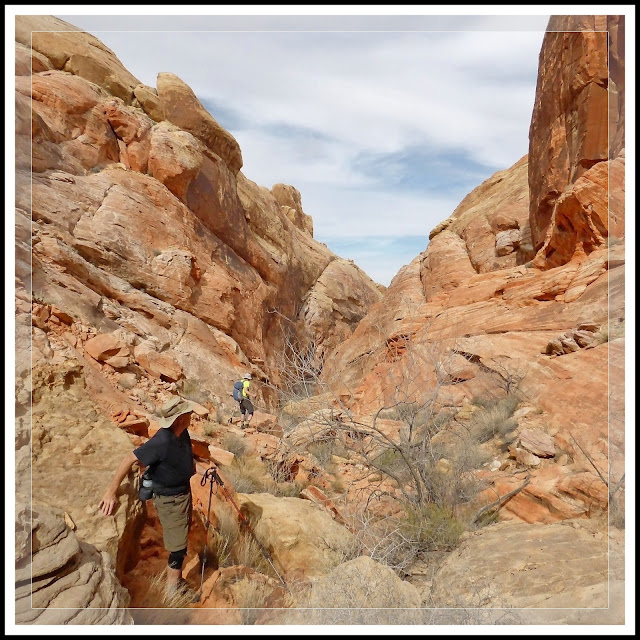
The Return: From the arch we retraced our same steps back to the sandy area at the beginning of the climb up the "fins" (Fig. 12). On our previous hike, Bob and I retraced our steps back to our starting point at the Scenic Vista #1 parking area, as seen in (Fig. 02). For this hike, as seen in blue on the map in (Fig. 08), they took us down through a very long, extremely steep, rocky ravine (Fig. 13). Because I was so busy concentrating on not falling, I didn't capture very many pictures (Figs. 14 & 15), and those I did get don't adequately portray how steep and difficult it was. There were places where we had to climb through a "hole" in the rocks and turn sideways to get through a narrow slot canyon area. Unfortunately this was made much more difficult for me as I ended up getting some of the worse case of leg cramps I have ever had while hiking. My cramps were so bad that my constantly stopping near the end caused Bob and a couple of the guides to be the last ones back, taking them 40 minutes more than everyone else to return. The good news was that, over the course of this hike provided me with dozens of more great pictures (Figs. 18-19).

(Fig. 12)
(Fig. 13)
(Fig. 14)
(Fig. 15)
(Fig. 16)
(Fig. 17)
(Fig. 18)
(Fig. 19)
Click here to return to [Valley of Fire State Park - Index Page]