{Click on any image to view full size, then use the back button on your browser to return to this page}
This page last updated on 07/16/2019
 |
| (Fig. 01) Parking Lot and general areas with petroglyphs |
Description of the Area: The Shooting Gallery Game Drive District is situated on the east flank of Badger Mountain and is an archaeological district rich in prehistoric rock art, hunting sites, and campsites. Studies of the area have shown that it was used as far back as 6,000 years ago, but, most intensively visited during the past 3,000 years, the site provides evidence that small groups of related households visited the area to hunt, gather wild plants, and to create rock art. Dart and arrow points, tool fragments, pottery sherds, and ground stone tools attest to Shooting Gallery's long use by family groups for hunting and harvesting plants. Two styles of rock art can be found at Shooting Gallery. The most common is Basin and Range tradition abstract and representational designs. The most commonly portrayed animal is bighorn sheep and Shooting Gallery contains one of the largest concentrations of bighorn sheep in Nevada. Hundreds of portrayals of this animal can be seen singly or in groups on Shooting Gallery's tuff outcrops (see side note). The second rock art style, the Pahranagat Anthropomorph, is found in small numbers at Shooting Gallery and is only found in Lincoln County. The Pahranagat Style is a schematic way of depicting people as either decorated rectangles (usually without heads) or as solid-pecked oval or rectangular forms that have hands with long fingers, a short line protruding from the top of the head and eyes indicated by negative space. Only the decorated rectangular type (or pattern-body anthropomorph [PBA] is found in the Shooting Gallery area. This style appears to have been made from around 3,000-800 years ago. Major concentrations of this style are found in Pahranagat Valley and the Mount Irish Archaeological District. For more detailed information on this area, refer to the previous page,
Shooting Gallery Game Drive District (Summary Page).
Side Note - What is Tuff?: Tuff is an igneous rock that forms from the products of an explosive volcanic eruption. In these eruptions, the volcano blasts rock, ash, magma and other materials from its vent. This ejecta travels through the air and falls back to Earth in the area surrounding the volcano. If the ejected material is compacted and cemented into a rock, that rock will be called "tuff."
 |
| (Fig. 02) |
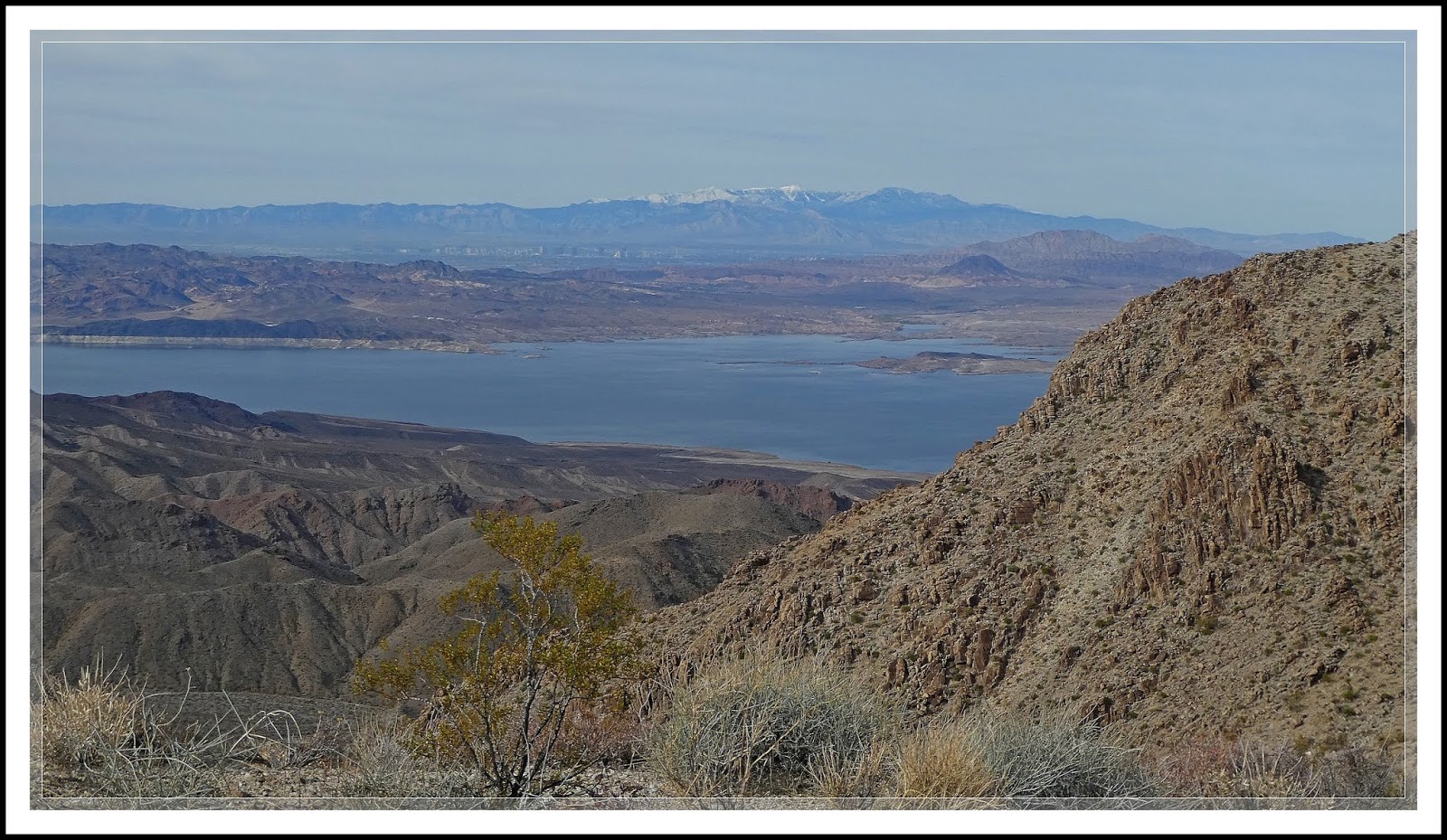
Getting There: The map in (Fig. 02) shows the route we took to get to the site. We followed South Richardville Road for 1.3 miles to Curtis Canyon Road, and turned left (heading west). This now becomes Repeater Road. At 5.7 miles, turn left and ascend a very steep, winding road (note: Though this gravel road is well graded, lowest gear, 4x4 is advised from this point to the summit). Staying to the right, follow Repeater Road. At roughly 7 to 7.5 miles, stay to the right as you pass through a beautiful, quite green valley. This stretch offers some nice views east towards the Pahranagat Valley (Figs 03 thru 05). At 8.7 miles, there is an extreme reverse hair-pin (right-hand) turn onto Hilltop Road, a rough narrower road. This road will end in a fenced parking lot after another 0.3 miles (about a total of 9.0 miles from South Richardville Road.
 |
| (Fig. 03) Click to Enlarge |
|
 |
| (Fig. 04) Click to Enlarge |
|
 |
| (Fig. 05) Click to Enlarge |
|
07/12/2019 Trip Notes: The diversity of the rock art found in this area is amazing. The 200 acres of of the tuff hillsides is a landscape covered with hundreds of rock art panels and elements. It records the mundane and ceremonial lives of ancient hunter-gatherers. Because there are no developed trails at the site, visitors are left to trudge through the hillsides in search of rock art, making it very difficult. However, a careful and thorough investigation of the area can reveal some unique petroglyphs. As a matter of fact, the Shooting Gallery contains one of the largest concentrations of bighorn sheep figures in southeastern Nevada. Because there were three of us on this visit, we tried to spread out in an effort to help insure that we didn't miss any sightings. As you can see from (Fig. 01) there are four identified areas with groupings of rock art. As a result we attempted to make a systematic approach of areas I & II. Leaving the parking area we hiked down to the wash below (Fig. 07) and headed to the spot designated as "Site I". For the purpose of creating this page, I have tried to group pictures of our findings by area. Because there were so many panels I have only included a selection of the better examples onto this page. The slideshow at the end of the page is inclusive of all the pictures I captured. Here are our findings.
 |
| (Fig. 06) |
Shooting Gallery Site I: Climbing down from the parking area, we crossed the sagebrush flats in the wash (Fig. 07), and climbed up the west facing hillside to area 1. After maneuvering around the tuff boulders for considerable time we eventually came to the area considered to be the village site, area I. Once we located this area we found several possible places amongst the boulders that could have been used as places where several people could have inhabited them for short periods during their visits to the area (Figs. 08-10). Between here and the wash, I found several lithic scatters (Fig. B). Refer to side note on Lithic Scatter.
 |
| (Fig. A) Click to Enlarge |
Side Note - Lithic Scatter: Lithic scatter are chips of stone left over while making arrowheads, scrapers, and other tools (Fig. A). These pieces consist entirely of lithic (i.e., stone) chipped stone debris. This is a common prehistoric site type that is contrasted to a cultural material scatter, which contains other or additional artifact types such as pottery or bone artifacts. It is usually flint because it is a hard, sedimentary cryptocrystalline form of the mineral quartz, categorized as the variety of chert that occurs in chalk or marly limestone. Flint was widely used historically to make stone tools. Being durable, flint (or other worked stone), usually survives. Despite their potential importance, scatter sites are generally neglected as an archaeological resource.
 |
| (Fig. B) |
In archaeology, a lithic flake is a "portion of rock removed from an objective piece by percussion or pressure," and may also be referred to as a chip or spall, or collectively as debitage. The objective piece, or the rock being reduced by the removal of flakes, is known as a core. Once the proper tool stone has been selected, a percussor or pressure flaker (e.g., an antler tine) is used to direct a sharp blow, or apply sufficient force, respectively, to the surface of the stone, often on the edge of the piece.
To date, many archaeologists regard the lithic reduction as the process of fashioning stones or rocks from their natural state into tools or weapons by removing some parts. Normally the starting point is the selection of a piece of tool stone that has been detached by natural geological processes, and is an appropriate size and shape. Flakes are often quite sharp, with distal edges only a few molecules thick when they have a feather termination. These flakes can be used directly as tools or modified into other utilitarian implements, such as spokeshaves and scrapers Many archaeological industries are identified almost entirely by the lithic analysis of the precise style of their tools and the chaîne opératoire of the reduction techniques they used.em as so disturbed and damaged that they are rarely worthy of detailed attention.
The tuff boulders on the rock walls surrounding the open camp area were covered with a variety of pertroglyphs. We were unable to locate the tinaja that was reported to hold water long into the summer. After taking dozens of pictures of petroglyphs, we decided to move on to the next area (Site II), WPs 4 & 5 on (Fig. 06). It appeared that this area was located roughly 50 feet to the west and required climbing up an additional several hundred feet to reach. I found climbing the rough and slippery tuff boulders too difficult for my current limitations and decided to turn back, letting Bob and Ron continue. I hiked back down to WP 2 in the wash and waited for their return. Even though they did reach the site II area, they admitted that it was rather strenuous and took a lot out of them.
 |
| (Fig. 07) |
 |
| (Fig. 08) Click to Enlarge |
|
 |
| (Fig. 09) Click to Enlarge |
|
 |
| (Fig. 10) Click to Enlarge |
|
 |
| (Fig. 14) Click to Enlarge |
|
 |
| (Fig. 15) Click to Enlarge |
|
 |
| (Fig. 16) Click to Enlarge |
|
 |
| (Fig. 17) |
Side Note on Petroglyphs in Figures 08 thru 17: (Figs. 08-10), pictures in the "village area"are examples three places where people could have spent night during their visits to the area. Obviously (Figs. 11 & 14), many panels contain jumbled mixtures of elements that defy explanation, while others (Fig. 12) clearly show elements of bighorn sheep, while others (Fig. 13, 15, 16) just make you wonder? From pictures I've seen before, the element in (Fig. 17) may be indicative of a lizard. The other problem is that many panels have natural damage due to weather and other elements that make it impossible to see what the original element may have been intended. (Fig. 15) may have been trying to portray rain or a "flow" of water. The case is that without the ability to talk with the author, no one will ever really know the intended message.
Shooting Gallery Site II: Continuing to climb outward and upward, Bob and Ron eventually came to the are designated as Site II. This area is recognized as two of Shooting Gallery's better known petroglyphs, the Seven Sheep and the Starburst Deer. Because I did not hike to this area, Bob Croke and Ron Ziance took these pictures.
 |
| (Fig. 18) |
|
 |
| (Fig. 19) |
|
 |
| (Fig. 20) |
|
 |
| (Fig. 24) |
 |
| (Fig. 25) |
|
 |
| (Fig. 26) |
|
 |
| (Fig. 27) |
|
Side Note on Petroglyphs in Area II: The pictures in figures 18 through 27 are from Area II that were taken by Bob Croke. Though there are several petroglyphs containing bighorn sheep, the picture in (Fig. 18) is the best one in the area that is referred to as the "Seven Sheep", though I count more. The petroglyph in (Fig. 24) showing what appears to be three people holding hands is a very interesting element and one that is not very often portrayed. The last three pictures in (Figs. 25 thru 27) are of the "Starburst Deer".
This unusual deer-like figure has several long lines radiating from its head and is perhaps the best known motif at the site. A small number of depictions of birds, which are very rare in Great Basin rock art, can also be found at the site.
Throughout our day of hiking we had more than one opportunity to observe a variety of lizards. Today we captured pictures of a Collared Lizard (
Great Basin Collared Lizard (Crotaphytus bicinctores) (Figs. 28 & 30) and another of a Zebra Tailed Lizard (
Western Zebra Tailed Lizard (Callisaurus draconoides rhodostictus) (Fig. 29). Zebra-tailed lizards are very tolerant of extreme heat. Both times they exhibited the flight behavior typical of this species - wagging her striped tail as a distraction from her body, and even doing a push-up display in a warning not to come any closer. Don't know why the tongue of the Great Collared Zebra Lizard is sticking out in (Fig. 30). There didn't seem to be anything on the rock that he was interested in. Could it have been that he was just doing it to cool himself in the scorching heat.
 |
| (Fig. 28) |
 |
| (Fig. 29) Great closeup taken by Robert Croke |
 |
| (Fig. 30) |
 |
| (Fig. 31) Click to Enlarge |
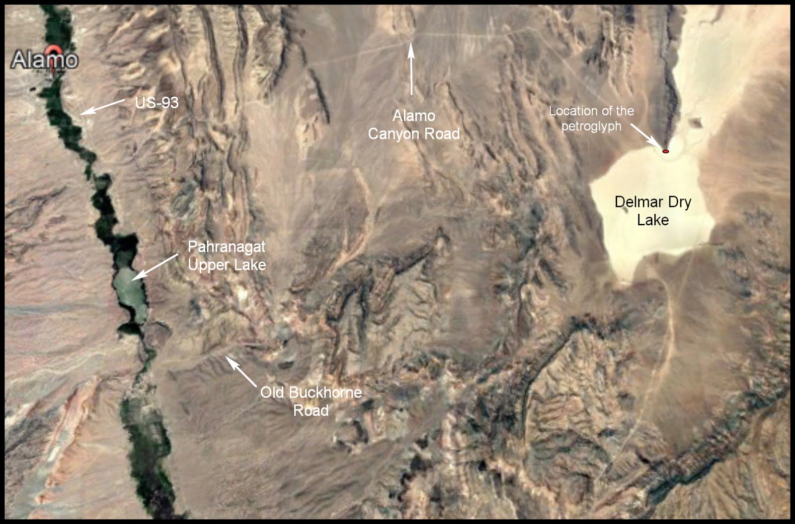
Hot and quite exhausted from our hiking of the hillsides, we drove to the one of the picnic areas located along the Upper Lake of the Pahranagat National Wildlife Range. After a relaxing picnic lunch we decided to take one more short trip before heading home. We drove out onto the Old Buckhorn Road and Alamo Canyon Road to the large Delamar Dry Lake bed in search of some petroglyphs (Fig. 31). Although surrounded by rocky terrain with boulders and large outcroppings, these roads are not very rocky. Aside from a few washboard sections, it was very smooth for the entire drive. After about 12 miles of riding we came to the dry lake bed but only found one rock with some petroglyphs on it (Fig. 32).
 |
| (Fig. 32) |
Side Note - Delamar Dry Lake: Delamar Dry Lake is a dry lake bed located in the Dry Lake Watershed near Alamo in Lincoln County, Nevada. It is located on federal land administered by the Bureau of Land Management. Delamar Lake Landing Strip, established in 1943, was designated as an emergency landing site for the X-15. No structures were built there. The lake bed remains, but it is no longer maintained as an airport. During Flight 1-63-104 on May 6, 1966, an X-15 experienced an engine failure and landed at Delamar Dry Lake. The U.S. Air Force now refers to Delamar Dry Lake Bed as "Texas Lake" because of its resemblance to the state of Texas from the air.
Clicking the picture-link below will open OneDrive in a new window and a folder containing 82 pictures taken on two trips to the Shooting Gallery Rock Art site. To view the show, click on the first picture in the folder and you will get the following menu bar:
Clicking the "Play slide show" will play a fullscreen window of the slide show.
___________________________________________________
Note: Every attempt is made to provide accurate information, but occasionally depictions are inaccurate by error of mapping, navigation or cataloging. The information on this site is provided without any warranty, express or implied, and is for informational and historical purposes only.