Wednesday

Sloan Canyon NCA Hikes - 05/19/2020 Trip Notes

{Click on any image to view full size, then use the back button on your browser to return to this page}
This page last updated on 05/25/2020

(Fig. 01)
Directions: Refer to ... Sloan Canyon NCA -Summary Page
Description of Area: Refer to ... Sloan Canyon NCA -Summary Page
Background and History: Refer to ... Sloan Canyon NCA -Summary Page

05/19/2020 Trip Notes: Today I once again attempted to make the hike to Sloan Canyon with Jim Herring and his daughter Christina. Same as the last time I attempted this hike back on 6 Feb 2020, I was unable to do much more than a mile. Today, due to the COVID-19 the visitor center trailer had been closed and removed from the site. The .07 mile Nawghaw Poa Road leading to the visitor center was barred and locked. We parked on Democracy Drive and walked up Nawghaw Poa Road. About 3/4 of the way up the road we left the road and walked southeast on a trail that led to the old parking area, and then down into the Sloan wash. We then followed the wash to where it interested with the BLM Sloan Trail 100 (Fig. 03 and 04) and then on to the intersection of the BLM Trail 100 and the BLM Trail 200. When Jim and Christina arrived at the intersection, they took Horseman's BLM Trail 200. After reaching the petroglyph area, they returned by taking the BLM Trail 100. The total distance they walked was 6.2 miles.

At this point the wind was guesting greater than 30 mph and I hiked up the stone steps on the side of the wash (Fig. 04) and headed back. I observed dozens of lizards while hiking. I actually spotted several instances of horned lizards (Fig. 05 & 06). (Southern Desert Horned Lizard (Phrynosoma platyrhinos calidiarum) These lizards are so well camouflaged that they are almost impossible to spot (Fig. 07). On the way back, between the festination and the wind guests, I fell forward on my face. I sprained my baby finger and bruised a rib, other that that I was okay. It could have been worse. The last 3/4 of a mile was a bitch.

(Fig. 03)
(Fig. 04)
(Fig. 05)
(Fig. 06)
(Fig. 07)
(Fig. 08)
(Fig. 09)


Note: Every attempt is made to provide accurate information, but occasionally depictions are inaccurate by error of mapping, navigation or cataloging. The information on this site is provided without any warranty, express or implied, and is for informational and historical purposes only.

White Owl Canyon Hike

{Click on any image to view full size, then use the back button on your browser to return to this page}
This page last updated on 01/25/2020
(Fig. 01)
Directions: This hike is located along Lakeshore Drive in Lake Mead National Recreation Area, about 30 minutes southeast of Las Vegas. From the intersection of Highway 93/95 and Lake Mead Parkway, drive east on Lake Mead Parkway over the hills to the park entrance station. Then continue east on what is now Lakeshore Road. You will shortly pass the intersection with Northshore Road. Continue on Lakeshore Road east and south for 3.8 miles to 33 Hole Road. Turn left and drive east on the access road towards the lake and picnic areas. 33 Hole Road leads to three scenic overlooks, each with a different name. Turn left towards Three-Island Overlook and drive into the parking lot at the end of the road. Park here, this is the trailhead.

Description of Area: From the trailhead, the route runs past a few trailhead signs by the west-most picnic table. From here you are presented with a view of the flats looking toward the western most edge of Lake Mead. Directly in front of you, a loosely graveled the trail heads down over the side a of the very steep hill, down to the flats below.  The flats are a now-dry lake bed. Referring to the pictures in (Fig. 02) you can see how the area below the hill was once covered with water from the lake twenty years ago. Today the route continues west through saltcedar thickets following use-trails that lead onto north-facing hillsides. Following the contour around, the route passes a bit of a point and turns southwest into what is known as White Owl Canyon. 25 years ago, the water from the lake nearly reached the mouth of owl canyon. The narrows of the canyon were cut into solid rock by flowing water. The rock here is a type of conglomerate formed from ancient alluvial fan deposits (Fig. 09). When alluvial fan deposits consolidate to become conglomerate rock, geologist call it "fanglomerate" rock, combining the terms "alluvial fan" and "conglomerate."
SIDE NOTE: As of Sunday, January 26, 2020 at 6:00:00 PM the level of Lake Mead is 134.90 Feet. The level is 134.90 feet below full pool of 1,229.00 (MSL - Mean Sea Level: The average level of the ocean's surface, calculated as the arithmetical mean of hourly tide levels taken over an extended period and used as the standard for determining terrestrial and atmospheric elevations and ocean depths.)        Click here to read the full side note titled  20 Year Drought & Water Levels at Lake Mead
(Fig. 02) Made by Bob Croke
(Fig. 03)
(Fig. 04)
(Fig. 05)
(Fig. 06)
(Fig. 07)
Hike Notes Continued:  After continuing on the flats, the route continues west through saltcedar thickets following use-trails that lead onto north-facing hillsides and then turns southwest into White Owl Canyon. Before long, the walls steepen and become deep as the route enters the first narrows area (Fig. 08), which is about 1/4-mile long. This size of this canyon is quite impressive. As we began winding our way through the narrows, we looked for the big splashes of "white wash" high on the rock walls. The white wash is Barn Owl poop. Lower in the canyon, small patches of bird poop reveal the presence of smaller birds, probably Rock Wrens and Say's Phoebes. Beneath the white wash (Fig. 11) produced by the owls, we looked for owl pellets (Fig. 12). These are oblong clumps of bone and fir that were regurgitated by owls. The pellets usually are 2- 3 inches long by about 1-inch in diameter. Pellets are coughed up, not pooped out, so they are relatively clean and safe to pick up and examine. Barn owls eat their prey entire without ripping it apart, so they consume everything, including the indigestible parts. They can't pass the indigestible parts, so they cough them up and spit them out. Often large leg and arm bones are evident on the surface, and skulls and jaws are easy to see. The owls here eat lots of desert woodrats and kangaroo rats. About the only thing of interest was a nest higher on one of the walls. We assumed that it was an owl nest (Fig. 13). Just beyond the last of the white wash on the rock walls, the narrow canyon opens abruptly just below Lakeshore Road. A culvert runs under the road (Figs. 14 & 15), which provides easy access to the other side of the road. On our return, the view in (Fig. 16) is of the flatbed area as you exit the canyon. All in all there wasn't anything really outstanding except for the beautiful narrow canyon. We didn't expect to see an owl. Don't even know if they still any longer inhabit the canyon. Just another local hike off our list of hikes around Las Vegas. Just another beautiful day enjoying hiking, good friends and fellowship.

(Fig. 08)
(Fig. 09)
(Fig. 10)

(Fig. 11) Click to enlarge and view the owl (white) poop 

(Fig. 12)
(Fig. 13) See owls nest
(Fig. 14) View from the other side of Lakeshore drive
(Fig. 15) Culvert under Lakeshore Drive
(Fig.16)


Note: Every attempt is made to provide accurate information, but occasionally depictions are inaccurate by error of mapping, navigation or cataloging. The information on this site is provided without any warranty, express or implied, and is for informational and historical purposes only.


Wildflowers - Cottonwood Cove and Eldorado Canyon.

{Click on any image to view full size, then use the back button on your browser to return to this page}
This page last updated on 04/01/2020

(Fig.01)
(Fig.02)
(Fig. 03)
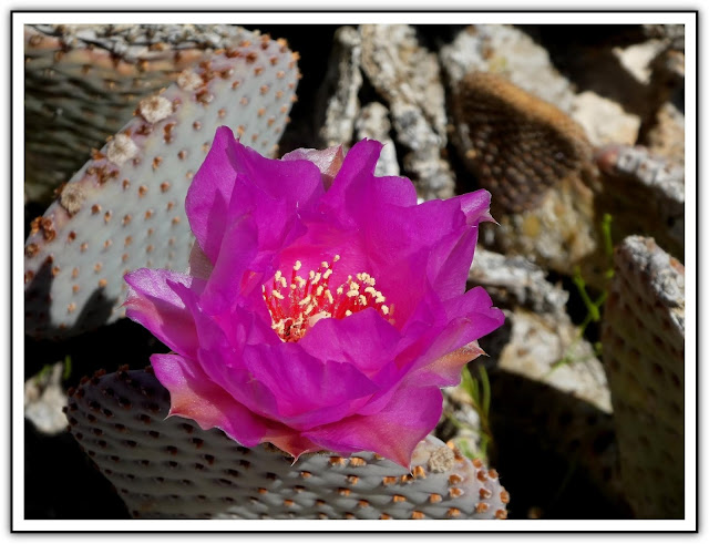
04/01/2020 Trip Notes: Due to the coronavirus, access to the Cottonwood Cove inside the Lake Mead National Recreation Area was closed and we were turned around at the LMNRA check point. Even though we couldn't drive to the lake, there were some wildflowers along the sides of the road. Even though it was just a little early in the season, the Beavertail Pricklypear (Opuntia basilaris)  cactus were just beginning to bloom (Figs. 01-03). With its brilliant magenta flowers, they can be seen from a distance and are always eye catching. Next there is a wide variety of wildflowers, there were many more that I didn't even catch (Fig. 05). Then there is always another standout that is easily spotted, the bright orange the Desert Globemallow (Fig. 06). Even though we spotted several wildflowers, we were not overly excited as compared to some previous years. After apicnic lunch at the library in Searchlight, we drove down to the end of the road in Eldorado Canyon. Lots of yellow,but not much else. Here are a few pages from previous years ... Cottonwood Cove Wildflower Visit2017 Desert Foliage2016 Desert Foliage.

(Fig. 04)
(Fig.05)
(Fig. 06)

Note: Every attempt is made to provide accurate information, but occasionally depictions are inaccurate by error of mapping, navigation or cataloging. The information on this site is provided without any warranty, express or implied, and is for informational and historical purposes only.


Las Vegas Ski and Snowboard Resort

{Click on any image to view full size, then use the back button on your browser to return to this page}
This page last updated on 03/15/2020

(Fig.01)
(Fig. 02)
Directions: From US 95 northwest of Las Vegas, take SR 156 southwest for 17.25 miles into Lee Canyon until the road ends at a parking area beyond the entrance to the Las Vegas Ski and Snowboard Resort (Fig. 01). Distance is about 35 miles from Las Vegas.

Description of Lee Canyon Ski Resort It is located in the Humbolt-Toiyabe National Forest and Spring Mountains National Recreation Area, commonly referred to a Mt. Charleston. Lee Peak is 11,289 feet, only a few hundred feet below Mount Charleston, the eighth  highest peak in Nevada. Lee Canyon is only about 32 miles northwest of Jim's house. Even though we have been there several  times in the past, it has always been in the spring, summer and fall months. Here are some pictures we took on a summer trip in July of 2016 (Lee Canyon Summer Trip).  Winter visitors are greeted with towering peaks of limestone sitting above 445 acres of terrain that serve as backdrop for their skiing, snowboarding, snowshoeing, or hiking adventure (Fig. 01). It has 860 vertical feet of lifts served terrain, 1,919 vertical feet of hiking routes, 24 serviced snow trails and 3 lifts, plus a tubing area, it truly is Las Vegas' mountain getaway spot (Fig. 02). Avg. Annual Snowfall: 129 in. Most people don't even know that there is  ski resort 35 minutes from Las Vegas. In the 2009-2010 it had over 180 days of skiing.

(Fig. 03)
(Fig. 04)
03/13/20 Trip Notes: A few weeks later we took another drive across Deer Creek Road to Lee Canyon. Even though it was an overcast day, there had been more snow the night before and we still got some good snow pictures. Click here to see the pictures ... Snow Pictures in Mount Charleston Area.

02/24/20 Trip Notes: On 02/24/2020 Jim Herring and I decided to take a ride up to the Las Vegas and Snowboard Resort. Though it doesn't look it, Lee Canyon has had over 120 inches of snow this year. A new multimillion dollar two-story, 10,000-square-foot hillside property, located near the resort’s main lodge, (Fig. 05 &  09), features a heated terrace, patio dining space, bistro, expanded restroom facilities and a ski-in, ski-out bar. We spent over an hour watching people ski up and down the resort (Figs. 06, 07, 08, 10). Eventually we began to freeze and headed back to the car and headed home.

(Fig. 05)
(Fig. 06)
(Fig. 07)
(Fig. 08)
(Fig. 09)
(Fig. 10)


Note: Every attempt is made to provide accurate information, but occasionally depictions are inaccurate by error of mapping, navigation or cataloging. The information on this site is provided without any warranty, express or implied, and is for informational and historical purposes only.


Coyotes - vs Wolves or Foxes

{Click on any image to view full size, then use the back button on your browser to return to this page}
This page last updated on 02/23/2020
(Fig. 01)
Picture Notes: The pictures in (Figs. 01-03) were taken on 01/29/2020 off Kingman Wash Road and Fortification Hill Road in the Lake Mead National Recreation Area, about 2 miles over the bridge into Arizona. Here is the page for the place where we took these pictures ... Fortification Hill Road. Because I forgot my camera today, my friend Jim Herring, shot all of the pictures shown here. It is difficult to differentiate the difference between Coyotes and Wolves. You decide. In all of my hiking I have only seen coyotes on three occasions. The first time was while driving Bitter Spring Backcountry Byway Road. The last three pictures (Figs. 05-07) were the two coyotes we spotted near Bitter Spring. Here is the page for the place where I took these pictires ... Bitter Spring Backcountry Byway.

(Fig. 02)
DescriptionCoyotes vs wolves and foxes. It may be challenging to spot the difference between a coyote and a wolf or fox because of their similarities at a glance. But, looking closely, one would firstly notice that coyotes are much larger than the foxes. Coyotes are larger than foxes but are smaller than the wolves. Unlike a wolf, a coyote has a bushy, thick tail, which it holds low to the ground. Coyotes hunt primarily in pairs, while wolves hunt in packs. As a point of interest, the animals we observed today were three hunting food together. Based upon the descriptions below, I think these are wild Coyotes. 

Coyotes can weight from 20 to 46 pounds and have a long snout with triangular ears. They are larger than foxes but smaller than the wolves. Coyotes average 24 inches tall at the shoulder and, including the tail are approximately four feet in length. Coyotes in the desert average about 20 pounds, while those found in mountainous areas can average twice that. Females are slightly smaller than males. The coat is predominantly gray, changing to tan along the belly, legs, muzzle and ears. Some guard hairs, as well as the tail are tipped with black. The intensity and amount of coloring varies and individuals are usually lighter in the winter. The legs of a coyote are visibly thinner than those of a wolf. Coyotes can hunt during the day. Wolves generally have gray, black, or white fur and are bigger in size than the coyotes.

In general their habitat range from the low desert valleys to the alpine ridges. Coyotes are found in about any type of habitat where they can find food and a place to hide. They seem to show some preference for brush covered rolling hills and flats. Coyotes have perhaps the most varied habitat of any animal in Nevada. The coyote is an opportunistic feeder. In most areas of Nevada, rabbits, rodents and carrion make up the bulk of the coyote diet. Coyotes in urban areas forage at landfills and raid garbage cans and have been known to take domestic dogs and cats.

(Fig. 03)

(Fig. 04)
(Fig. 05)
(Fig. 06)
(Fig. 07)

_________________________________________________

Note: Every attempt is made to provide accurate information, but occasionally depictions are inaccurate by error of mapping, navigation or cataloging. The information on this site is provided without any warranty, express or implied, and is for informational and historical purposes only.