Showing posts with label LMNRA. Show all posts

Tuesday

Bittersprings Road - LMNRA

{Click on any image to view full size, then use the back button on your browser to return to this page}
This page last updated on 05/26/2019

(Fig. 01)
(Fig. 02)
Directions: This road is located along Northshore Road in Lake Mead National Recreation Area, about 50 minutes east of Las Vegas. From town, drive out to Lake Mead. From the intersection of Lakeshore Road and Northshore Road, drive north on Northshore Road for about 25.9 miles. Shortly before the mile marker 26, watch for the sign (Fig. 02) and turn left onto Bittersprings Road.


Description of Area: Bittersprings Road (NPS Rd 101), is a 6.4-mile backcountry road that runs north from Northshore Road to Bitter Spring, then continues northeast following Echo Wash back to Northshore Road. Bittersprings Road provides access to Bitter Spring Backcountry Byway that travels west to Buffington Pockets. From the pavement, the graded road runs northeast and then north as it descends gently through rolling hills (Fig. 01). The road surface here is firm dirt, and the Park Service maintains it from time to time. The road eventually follows washes descending towards a gap in Echo Hills (Fig. 03). Running down the bajada (Fig. 04), the road eventually reaches a signed road intersection (3.3 miles out). Here, the Bitter Spring Backcountry Byway runs left (also straight ahead), and Bittersprings Road continues to the right.

(Fig. 03)

(Fig. 04)
Turning right, the road runs out about 0.25 miles and drops into the sandy wash. For drivers in 2WD vehicles wishing to visit the spring, park on firm ground before dropping into the wash, and then walk the last few hundred feet to the spring (Fig. 05).

(Fig. 05)
05/23/2019 Trip Notes: When we reached the signed 3-way intersection, we turned right and headed to the Bitter Spring. It has been more than 4 years since I last visited the Bitter Spring. See the last visit of [Bitter Spring] In addition to this year's heavy rains, flash floods during the fall of 2010 and 2012 scoured away most of the emergent vegetation, but the cottonwoods survived and the other vegetation is slowly growing back. The two large cottonwoods at the source of the spring appear to have taken a real beating (Fig. 06). What used to be a sandy wash is pretty much down to the bare rock along the way (Fig. 07). Much of the vegetation on both sides of the waters leading down the wash from the source of the spring have been washed away. The remaining vegetation show evidence that the waters that washed through here was pretty strong (Fig. 08). The last time I visited there were thousands of animal tracks in the water saturated sandy areas. We found a wild horse feeding on the grasses along the edge of the spring and even spotted two coyotes. We found no sign of life here on today's visit. (Click the link above to see pictures of these on the previous visit.)

(Fig. 06)

(Fig. 07)
(Fig. 08)
Bitter Spring is a quiet little place for birdwatching where water flows into the desert and forms a spot of green amid the vastness of the dry Mojave Desert. At the spring, vegetation includes two cottonwood trees and a few sprouts, lots of narrowleaf cattail, honey mesquite and desert willow, some catclaw acacia, black-banded rabbitbrush, and arrowweed, plus saltcedar that Land Managers are trying to eradicate (feel free to pull up seedlings). Walking around the surrounding desert is dry creosote bush, white bursage, and a few other hardy species. After walking around the area we headed back to the parking area downstream. The flow of the water coming from the spring was actually flowing at a very steady rate. In fact the ground was so saturated, sometime your foot would seek into the sand. There seemed to be more water than in past years.

We finally turned around and drove back to the signed intersection and started driving up the Bitter Spring Backcountry Byway Road headed towards Buffington Pockets. Somewhere along the way we either got lost, taking a bad turn, or the road we were on had gotten washed out due to heavy rains. The road got so narrow and rocky, it became impassable and we thought we should abandon it and return. Disappointed we paused to have a picnic bag lunch. Disappointed, we then drove back to the Bitter Spring and beyond it to the exit that took us up onto the Northshore Road. 


Note: Every attempt is made to provide accurate information, but occasionally depictions are inaccurate by error of mapping, navigation or cataloging. The information on this site is provided without any warranty, express or implied, and is for informational and historical purposes only.

Go Back to the previous page ... (Bitter Spring Backcountry Byway Road - Summary Page). 

Saturday

Index for Category - Lake Mead Lakeshore Drive

This page last updated on 04/13/2018

Click on a Title to View
      Lake Mead Lakeshore Drive:

      St. Thomas Nevada - Summary Page

      {Click on any image to view full size, then use the back button on your browser to return to this page}
      This page last updated on 04/17/2018

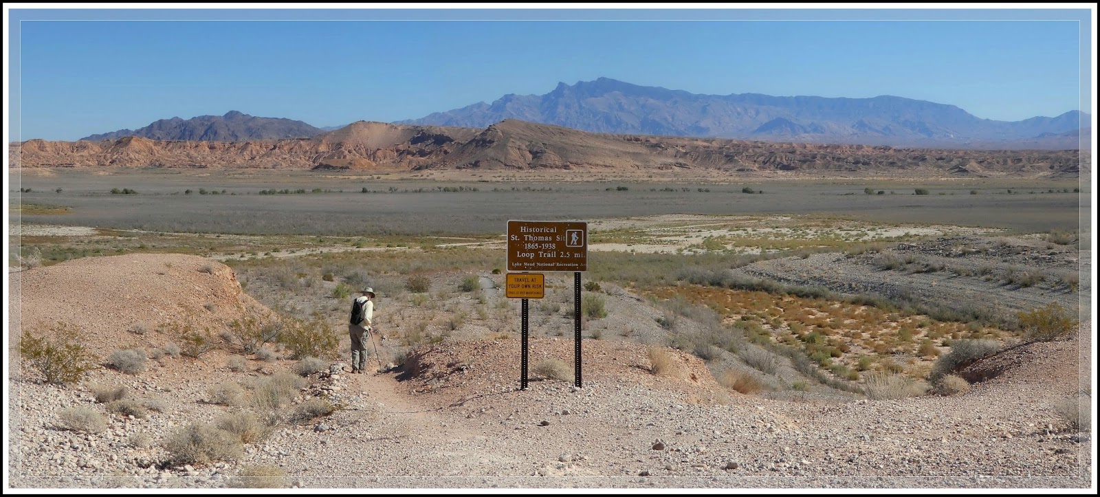
      (Fig. 01)


      (Fig. 02)

      Directions: St. Thomas is located approximately 82 miles NE of Las Vegas. From the Stratosphere Casino head northeast on Las Vegas Blvd about 3 miles and turn right to merge onto US-93/95. Go 12.5 miles and Merge onto NV-564 E/W Lake Mead Pkwy via Exit 61B. Heading east on NV-564 (Lake Mead Blvd) go over the mountains (passing between Frenchman Mountain to the south and Sunrise Mountain to the north) to the park entrance station. Pay the entrance fee ($5 per car or an annual pass), and proceed to the T-intersection with Northshore Road (NV Rt 167) and Lakeshore Road (NV Rt 166). Bear left and drive north on Northshore Road (NV 167) towards Overton, NV. Turn right opposite the Valley of Fire Road onto Old St. Thomas Road and travel 3.3 miles to the parking area and trailhead at the end. Though this road was wash out back in May of 2016, it has since been "regraded" and can be reached without a high clearance vehicle.

      General Description: St. Thomas, Nevada, elevation 1,204 feet, is a ghost town in Clark County, Nevada, in Mopa Valley near where the Muddy River flows into the Colorado River (Fig. 02). I have hiked this location on four occasions. From the parking and trailhead (Fig. 01), it is a moderate 2.5 to 3 mile hike to the shoreline, out and back hike. Do not wander too far off the trail or you may get stuck in the mucky sediment that used to be underwater. In addition, the town site has been over-run with an invasive plant species called Tamarisk. You must be careful not to walk on the stumps of the Tamarisk.  These hardy plants are both a nuisance and a potential safety hazard. The branches and leaves can produce cuts and bruising, while the trunks are very hardy and when cut to a stub (Fig. 04) can puncture the soles of your shoes. The is a vault toilet near the trailhead.

      St. Thomas was purchased by the US Federal Government and was finally abandoned as the waters of Lake Mead, created by the building of the Hoover Dam, submerged the town. It is now located within the Lake Mead National Recreation Area. The fluctuations of the lake water levels resulting from a series of droughts, St. Thomas has arisen from the depths several times since 1938; in 1945, 1963, and 2012. Today the town is still exposed and visitors can roam the roads and trails that were once a thriving wild west town. The map in (Fig. 03) is a pre-flooding reconstruction of  St. Thomas. The path we hiked of our recent 10/13/2016 visit is shown in yellow.
                                                             
      (Fig. 03)
      (Fig.04)
      10/13/2016 Trip Notes: Today I visited St. Thomas for the fourth time, this time with my friends Jim Herring and Blake Smith. As a result, I didn't take very many pictures, however, I did hike to a section of town that I had not visited before. Click here for pictures and info on today’s visit … St. Thomas - 10/13/2016 Trip Notes . 

      01/16/2014 Trip Notes: This was my third visit to this ghost town with the rock-hounds from Henderson’s Heritage Park Senior Facility. On this visit I was armed with a better map showing the layout for many of the towns more prominent buildings. As a result I was better able to identify more of the exposed foundation remains. Though it is very difficult to be 100% sure about the following foundation/building identifications - I have made them by judging their relationship on the map to various foundations that I am sure of. Click here for pictures and info on today’s visit … St. Thomas 01/16/2014 Trip Notes.

      04/05/2012 Trip Notes: This was my second visit to this town in four months. This three-mile hike provides the perfect opportunity to stroll walk back in time and use your imagination to envision what life was like before the waters of Lake Mead covered this small farming and railroad community; of days when schoolboys climbed the fruit trees and its fields were filled with orchards and grains. Though I had been  hopeful that I would be able to capture some budding plants and flowers, it was still too early in the spring. I did however, locate a few major foundations that I had missed on my previous visit here. Click here for pictures and info on today's visit ... St Thomas - 04/05/2012 Trip Notes. 

      12/15/2011 Trip Notes: This was one of the more interesting places we visited all year. Out of curiosity I decided to do some additional research on the town's history so as to add more meaning to the pictures that I captured on today's hike. Click here for pictures and info on today's visit ... St. Thomas - 12/15/2011 - Trip Notes.

      Wednesday

      Lovell Wash Prospects – Trip Notes for 01/23/2014

      {Click on an image to enlarge, then use the back button to return to this page}
      This page last updated on 04/16/2018
      EFP-P1000381
      (Fig. 01)
      Anniversary Mine Road-2
      (Fig. 02)
      01/23/2014 Trip Notes: Today I went back for yet another visit to the Anniversary Mine and Lovell Wash with the rock-hounds from Henderson’s Heritage Park Senior Facility. As this was my fourth visit to this area, I was looking for some place different to hike. While the majority of the group hiked to Anniversary Narrows, four of us decided to hike up to a group of mine prospects, seen in (Fig. 01) and the two red dots on the map in (Fig. 02), that we spotted on the west side Anniversary Mine Road and Lovell Wash, about halfway between North Shore Road and where the end of Anniversary Mine Road enters the wash. The hike from the road, across the desert (foreground in Fig. 01) down into the wash dropped about 100 feet in elevation. After crossing the wash, the relatively steep hike up the hillside to the highest of the two prospects was an elevation gain of slightly more than 200 feet. From this elevation, the view north (Fig. 03), looking back over Lovell Wash, the desert valley that we had just climbed; with the Gale Hills at the south edge of the Muddy Mountains in the background, was expansive.  Running nearly 50-60 feet straight into the hillside (Fig. 04), this prospect proved to be the most interesting of the two. Though we found nothing unusual inside (Figs 05 & 07), there was a birds nest (Fig. 06) high on the wall at the end of the adit. Looking due south from the front of this prospect (Fig. 08) revealed another prospect that is hidden from the road. This turned out to be an open area that was either dug or blasted out of the mountain ridge. After following a use trail around this ridge we located the other prospect (Fig. 09) that had been visible from the road. Unfortunately, this adit only went about 30 feet into the hillside and provided very little to explore. A climb to the steep jagged ridgeline above this last prospect revealed some very nice views down into another deep tributary wash (Fig. 10) that ran down into Lovell Wash (Fig. 11), several hundred yards below our initial crossing point. Once we got back down to the wash, we decided to head north (Fig. 12), hiking up to wash to Anniversary Mine Road, rather than climbing out and retracing our earlier route (The green line on the map in Fig. 02). As you can see from (Fig. 13), we found some very colorful geology along the way.
                            
      EFP-P1060063-P1060065
      (Fig. 03)
      EFP-P1060067
      (Fig. 04)
      EP-P1060056
      (Fig. 05)
      EP-P1060054
      (Fig. 06) 
      EP-P1060061
      (Fig. 07)
      EFP-P1060066
      (Fig. 08)
      EFP-P1060083
      (Fig. 09)
      EFP-P1060069
      (Fig. 10)
      EFP-P1060070-P1060071
      (Fig. 11)
      EFP-P1060086
      (Fig. 12)
      EFP-P1030179
      (Fig. 13)
                                [Click here to Return to the Lovell Wash Summary Page]

      Tuesday

      Bitter Spring - Summary Page

       {Click on an image to enlarge, then use the back button to return to this page}
      This page last updated on 05/282019

      EFP-P1040543
      (Fig. 01)
      Description: The last main point of interest on the southeastern end of the Bitter Spring Backcountry Byway Road is Bitter Spring itself. The spring is located on the northeast edge of Bitter Spring Valley at the beginning of Echo Wash. A little less than a quarter-mile long, this stretch of running water is along the north side of the wash road. Its water seeps out of the ground among thick stands of feathery tamarisk, before disappearing again in the sandy creek bed.


      EFP-P1120716
      (Fig. 02)
      05/23/2019 Trip Notes: On this trip to the Bitter Spring included Jim Herring, Bob Croak, Ron Ziance, Bud Stegmeier, Howard Saxon and myself. Even though our goal was to drive across the Bitter Spring Backcountry Byway Road to Buffington Pocket, we only got to explore the Bitter Spring once again. Click here for a description and pictures from this visit ... Bittersprings Road - LMNRA
      .

      09/12/2015 Trip Notes: The water from the spring flow in a eastern direction. At the northeast end of the wash the springs water disappears down into the wash-like road. Upon this visit I noticed that the four posts (Fig. 12) used to prevent vehicle entry up the wash were now gone; as well as the sign indicating that it had been done to help restore the natural plant life growing around the spring. Even though the water flow seem to be a little less than the last time I was here, I am always still surprised to see that this much water still runs year round, even after years of drought (Fig. 02). Not only were there thousands of animal tracks in the water saturated sandy area, we even came upon a wild horse feeding on the grasses along the edge of the spring (Fig. 03). As we walked up the flow of the spring toward its source, this lush area becomes more and more surrounded by tamarisk trees (Fig. 03 thru 05).
                                          
      EFP2-P1120703
      (Fig. 03)
      EFP-P1120714
      (Fig. 04)
      EFP-P1120723
      (Fig. 05)
      EFP-P1120725
      (Fig. 06)


      10/22/2013 Trip Notes: Though we noticed where the water from Bitter Spring exited and disappeared into the Bitter Spring Backcountry Byway Road, we continued going down the Echo Wash until we reached the North Shore Road bridge that crosses the wash (Fig. 07). As a result, the majority of these pictures (Figs. 01, 08, 09 & 10) were taken on our return trip up Echo Wash. At the point were the spring disappears down into the road, vehicle travel through the area of the wash is blocked by four posts and a sign indicating that this has been done to help restore the natural plant life growing around the spring. These are seen in the last two pictures (Figs. 11 & 12) as I walked back down to the spot where we parked. Not only were we amazed by how green this area was, but by how fast the water was running down the wash. To still have this much water running at this time of year, after a long dry summer, this spring must come from a very large underground aquifer being fed by all of the surrounding mountain ranges.
                                     
      EFP-P1040545
      (Fig. 07)
      EFP-P1040553
      (Fig. 08)
      EFP-P1040556
      (Fig. 09)
      EFP-P1040560
      (Fig. 10)
      EFP-P1040561
      (Fig. 11)
      EFP-P1040555-2
      (Fig. 12)
                                                  [Click Here to Return to the Previous Page]

      Monday

      Gypsum Cave

      {Click on an image to enlarge, then use the back button to return to this page}
      This page last updated on 04/06/2018


      EFP-P1000292
      (Fig 01)
      Gypsum Cave
      (Fig. 02) Click to Enlarge
      image
       
      04/24/2013 Trip Notes:
      After leaving NV-147 (Lake Mead Blvd) you must drive in about five miles on the Pabco Mine Rd before turning off and heading north onto a dirt road near a grouping of power line poles. Refer to (Fig. 02) There are several crisscrossing roads in this area, most all of which leading to a parking area (Fig. 03) below the cave. The view in (Fig. 03) was taken looking down from the cave entrance, back to the parking area. Note, Lava Butte is the dark, volcanic mountain in the very center of this view.
       
      To reach the cave entrance you must then climb a several hundred feet up a hill (Fig. 01) in front of the parking area. The dark area in the center of (Fig. 01) is the location of the cave opening. Unfortunately, for the shot of the cave’s entrance in (Fig. 04), I had to zoom in in order to eliminate the multitude of graffiti markings that some rather unscrupulous persons had sprayed all over the outside rock faces. It was really sad to see how much this area had been defaced. They even graffitied area inside the cave.

      Because it has been written that unexcavated areas of the cave still exist, we were hopeful that we might be able to explore its depths and find something of interest. Unfortunately, our exploration of the site (Figs. 05 & 06) revealed that the majority of the rooms were well below ground, and required much better lighting and climbing equipment than we had in order to be safely explored. The first room entrance we located had some wooden shoring (Fig. 07) near the opening, but then required you to squeeze through a very narrow opening to go any deeper. The second room’s entrance was a small opening that required a very steep decent into a very dark room (Fig. 08) that appeared to go much deeper. Without a stronger light, it was impossible to determine what we would be facing. Learn more about this site by reading the “Cave History” below.

      Climbing to the top of the ridge above the cave, seen in (Fig. 01), we were afforded a view of the open pit Pabco Gypsum mine and processing plant (Fig. 09), the largest drywall manufacturing operation on the West Coast. Mining at the Pabco plant started in the early 1960s. At the time, Pabco used to scrape gypsum from the land, but now, new technologies and methods allow them to drill and blast gypsum. Their manufacturing plant produces nearly a billion square feet of board annually; enough daily to line the innards of 800 homes. In 1994, Nevada State Historical Marker #103 was erected about a half mile from the cave's entrance, but it was removed by the  PABCO Mining Company, to discourage visitation of the area.
          
      EFP-P1000275
      (Fig. 03)
      EFP-P1000258
      (Fig. 04)
      EFP-P1000259
      (Fig. 05)
      EFP-P1000265
      (Fig. 06)
      EFP-P1000267
      (Fig. 07)
      EFP-P1000263
      (Fig. 08)
      EFP-P1000289-P1000290
      (Fig. 09)


      Cave History: Gypsum Cave, a six-room limestone cave in located in Sunrise Mountain, is considered to be among the oldest aboriginal sites in North America. The cave measures 300 feet long (deep) by 120 feet wide. Its rooms are filled with dry, dusty deposits. Gypsum Cave is significant because it has yielded artifacts related to early human occupation and information about the region's ancient ecosystem.

      Gypsum Cave Photo
      (Fig. 10)
      Back in 1930-31, archaeologist Mark R. Harrington (Fig. 09) unearthed various kinds of prehistoric materials from Gypsum Cave, proving that it was occupied by both humans and now-extinct mammals, specifically the ground sloth (Nothrotheriops shastense). His excavation yielded an extraordinary collection of terminal-Pleistocene paleontological and Holocene archaeological specimens. In different places within the cave, he found hand-carved wooden fore-shafts from dart/atlatl weapons, torches, stone points, and yucca fiber string. Since the advent of radiocarbon dating, it has been determined that the presence of sloths in the cave dates back to between 20,000 to 33,000 years BP (Before Present). In contrast, the human artifacts are much younger. Radiocarbon dates on the dart shaft fragment and nine other cane and wooden dart fragments taken from the cave’s six rooms range from 2,900 and 4,250 years BP. The oldest implement now documented from the cave is a fragment of a 9,280-year-old basket found in a crevice in Room 3. It is among the oldest pieces of basketry ever found in North America, and its weave is unlike that of other basketry traditions documented in the region.

      Friday

      Lakeshore Drive (Part I)

       {Click on an image to enlarge, then use the back button to return to this page}
      This page last updated on 02/18/2018  

      EFP-Lakeshore Scenic Drive - 33-hole Overlook
      (Fig. 01)
      09/23/2015 Trip Notes: My friend Jim Herring, Connie and I took a trip out to Lake Mead for a picnic lunch at the 33-Hole Overlook. (More on this area below) Even though a little overcast, it was very hot and so windy, it was trying to blow our lunch off of the picnic table.  I’ve certainly had better days out here. Jim and I tried to hike down to the water’s edge, but before reaching it we decided it was too hot to be out here hiking. Most impressive was how low the water line was as compared to my first visit here more than 10 years ago. The exposed landscape is quickly becoming a surreal landscape turning into more and more desert with every passing day.

      As a result of the roughly 15-year drought, today's water level is at 1,079-feet, down another 40 feet from just two years ago and more than 135 feet from the 2000 level of 1214-feet. At the present time, lake Mead is only at 38% full and hasn't been this low since they were filling it in the 1930s. Every day it is drawing closer to the 1,075-foot level, below which officials would declare a water emergency and begin rationing water allotments to Nevada and Arizona. The more the water level drops, the greater the chances that Hoover Dam's hydroelectric output might be seriously affected. Federal forecasters originally predicted that the Colorado River would flow at 71% capacity this summer, but they now say the figure could fall to 50% or lower. This summer, officials will make their projection for Lake Mead water in January 2016. If the estimate is below 1,075 feet, rationing kicks in: Southern Nevada would lose 13,000 acre-feet per year and Arizona would lose 320,000 acre-feet. California's portion would not be affected. The U.S. Bureau of Reclamation officials say there is a 21% chance of Lake Mead plunging below 1,075 feet by January. The odds increase to 54% for 2017.
                                         
      EFP-Lakeshore Scenic Drive - 33-hole Overlook-2
      (Fig.02)
      EFP-Lakeshore Scenic Drive - 33-hole Overlook-3
      (Fig. 03)
      Paragraph divider
      EFP-P1040969-P1040968
      (Fig. 04)
      03/21/2013 Trip Notes: This was the Heritage Park Senior Facilities’ first hike here for the 2013 season. As noted on the previous page, there are several pull-offs along this 11-mile stretch of road, and I think we hit them all. The last time our group visited here was on 01/19/2012. This post includes pictures from both visits. Note: The slide show on the [Previous Page]  includes pictures from all of my visits here.
          
      Las Vegas Bay Overlook: Heading north to south, this is the first stop. It provides views of the Las Vegas River that emanates from the Las Vegas Wash (Fig. 04) as it winds it way towards Las Vegas Bay (Fig. 05) and into Lake Mead. Driving past the Las Vegas Wash Campground, that looks like an isolated oasis lost in the vastness of the Nevada desert, you come to an area where you can hike down to the river at the mouth of the bay. There are a half dozen trails at lake level that wind about this area. It is sad to see how much this lake has receded in just the past 10 years. Today’s lake level is 1,119-feet, down 95 feet from the 2000 level of 1214-feet. Changing rainfall patterns, climate variability, high levels of evaporation, reduced snow melt runoff, and current water use patterns are putting pressure on water management resources at Lake Mead as the population depending on it for water and the Hoover Dam for electricity continues to grow. The minimum power pool elevation for producing electricity by the dam is 1,050-feet. When we moved here in 2003, about 85% of what you see in (Fig. 05) below was covered by water.
         
      EFP-P1040970-P1040972
      (Fig. 05)
      Three Island Scenic Overlook:  As you can see from the picture below (Fig. 06), this stop is know for its view of three large islands. Of course these days, with the current lake levels being so low, one can now see several more islands that never existed a few short years ago.
         
      EFP-P1010921 Stitch
      (Fig. 06)
      Rocky Point Scenic Overlook: Here, you can take a short walk out on the promontory for yet another nice view of the lake. I believe the picture below (Fig. 07) from last year’s visit was taken from this location.
         
      EFP-P1010924
      (Fig. 07)
      33 Hole Outlook: There is no information anywhere as to what the title of this outlook refers to, however, it is one of the best stops along this stretch of road. This turnoff splits into three separate parking areas, each of which lead to what is known as “Pitch Fork Cove”. From the middle parking area, there is a medium length trail that leads all the way out to the end of a long peninsula (Fig. 08). Several of us (Fig. 09) hiked all the way out to the end on a trail that goes around the point and returns on the opposite side. Not only did we encounter fishermen in more than one spot along the base of peninsula (Fig. 10), we got to observe a variety of birds and water fowl (Fig. 11). This turned out to be one of the nicest walks I have taken along the edges of the lake. (be sure to view the slide show on the previous page for more pictures)
         
      EFP-P1050007
      (Fig. 08)
      EFP-P1050001
      (Fig. 09)
      EPB&W-P1040983
      (Fig. 10)
      EFP-P1040979
      (Fig. 11)