{Click on an image to enlarge, then use the back button to return to this page}
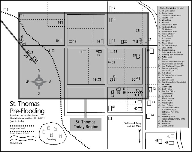 |
| (Fig. 01) |
12/15/2011 Trip Notes: This was one of the more interesting places we visited all year. Out of curiosity I decided to do some additional research on the town's history so as to add more meaning to the pictures that I captured on today's hike. As previously noted, the town was abandoned in 1938 as the rise in waters from the completion of the Boulder Dam (now Hoover) began to reach the small town. The first two pictures below, courtesy of the UNLV Libraries Digital Collection, show one of the last vehicles to leave the area and the town being overtaken by water. The next picture is an aerial view of the town as the ever rising waters began to encroach it.
|
|
|
|
|
Today, due to the receding waters of an eight year drought, many of the towns' remaining building foundation are visible. Starting from the trailhead (see above), it's about 40 down to the valley floor. Once you reach the base of the valley, it's approximately a half mile before you reach the first exposed foundation. At one time there was nearly 60 feet of water covering the town.
|
|
|
|
 |
| #34 in Fig. 01 |
The Schoolhouse: As none of the building remains that we found were identified, I began searching the Internet for pictures that might help, which proved to be a very difficult task. Probably the largest foundation has many visitors incorrectly guessing that it might be the Gentry Hotel (see insert), however it is the old schoolhouse (#29 on the map in Fig. 01), which also doubled as the town meeting hall and the Mormon Church. The top picture in the collage below is of the ‘rear’ of the school (shown in the bottom middle), while the bottom two are either side are of its front entrance. |
 |
| The Schoolhouse - #29 on the map in Fig. 01 |
|
|
|
 Home of Wally Frenner & Lizzie Gibson (#10 on the map in Fig. 01): These photos below appear to be just one of the homes of a local resident. Notice the (grated over) well or cistern at the rear of the property. Just about every ruin that we encountered had one of these located near the rear of the property and were fully lined (see insert). Some had a trough located right next to it. presumably, that could be filled to allow horses and farm animals to drink from it. Notice the wood ‘framing’ in the window of the right-hand picture (click to enlarge). Home of Wally Frenner & Lizzie Gibson (#10 on the map in Fig. 01): These photos below appear to be just one of the homes of a local resident. Notice the (grated over) well or cistern at the rear of the property. Just about every ruin that we encountered had one of these located near the rear of the property and were fully lined (see insert). Some had a trough located right next to it. presumably, that could be filled to allow horses and farm animals to drink from it. Notice the wood ‘framing’ in the window of the right-hand picture (click to enlarge).
|
 |
| Home of Wally Frenner - #10 on the map in Fig. 01 |
|
Ice Cream Parlor (#20 on the map in Fig. 01): I wish that I had taken a few more pictures of these remains. There were actually two of these pieces (bottom left) lying side-by-side, with a doorway space in between them. We thought that they had fallen forward, meaning the arch would have been at the top. From the picture on right, it appears that they actually fell backward toward the rear of the building. The bottom right-hand picture in the collage, courtesy of the UNLV Libraries Digital Collection, is of Lorraine Thomas and her father standing in front of the shell of a building, probably Hannig's Ice Cream Parlor. Notice that the cement ‘apron’ and path leading up to the building is the same in both photos.
|
 |
| Ice Cream Parlor - #20 on the map in Fig. 01 |
|
Below are eight shots captured at various points along the trail that cover a wide variety of subjects. Numbered 1-8, left to right they are:
(1) An irrigation well in the middle of a field.
(2) One of dozens of mountain lion tracks that we encountered along the trail.
(3) & (4) Two pictures showing construction detail of some foundation work. Some of the structures appear to have been made by pouring concrete into some kind of molds. In addition to having 12-inch thick walls, many of the individual home structures were half buried in an effort to keep the inside of the building relatively cool.
(5) Remains of a tree trunk. Their are many tree stumps and fence posts that provide evidence of street and curb boundaries.
(6) A picture of the dried out river bed of the "Muddy River".
(7) & (8) A couple of miscellaneous shots of an (unknown) plant and a fire 'scorched' tree trunk. |
|
|
|
|
|
|
 |  |
|
|
In the picture above, the Tamarisk in the foreground has been cut down to expose the foundation to view. The Tamarisk in the rear has been allowed to continue its growth. The Tamarisk in this valley plain is amazing. It’s thick, dangerous, and everywhere. You must wear long pants. There is no avoiding it. It will cut your skin because of the sharp branch spurs on them. So are sharp, pointed branches coming out of this surface. Beware walking on this cover because your feet will sink in it and the pointed branches will not. They will penetrate everything except thick leather soles.
Tamarisk: The genus Tamarix (tamarisk, salt cedar) is composed of about 50-60 species of flowering plants in the family Tamaricaceae. The deciduous tamarisks growing here are shrubs or trees that form dense thickets growing from 3 feet to more than 30 feet in height. These deciduous trees generally establish themselves in disturbed and undisturbed streams, waterways, bottom lands, banks and drainage washes of natural or artificial water bodies, moist rangelands and pastures, and other areas where seedlings can be exposed to extended periods of saturated soil for establishment. Tamarisks are characterized by slender branches and grey-green foliage. The bark of young branches is smooth and reddish-brown. As the plants age, the bark becomes bluish-purple, ridged and furrowed. They are often encrusted with salt secretions. As a species, Tamarix are fire-adapted, and have long tap roots that allow them to intercept deep water tables and exploit natural water resources and can tolerate very alkali conditions. (It has been suggested that they may have been planted around structures here to ‘suck up’ ground water and help keep homes dry.)
|
|
|
|
|
|
(OPTION 1) Each show is designed to run automatically in place, without leaving the current browser window. If the show is not already running, just click the large "Play" button in the middle of the picture and let it run.
(OPTION 2) Running the cursor over the picture being shown will PAUSE the show and bring up a navigation bar at the bottom of the slideshow window with Pause, Forward and Back buttons, allowing you to start, stop or manually forward or back up pictures one at a time. |
|
Slideshow Description:Though some are duplicates of those shown on this page, the slideshow above contains 43 pictures that were taken at St Thomas, Nevada.
|


 Home of Wally Frenner & Lizzie Gibson (#10 on the map in Fig. 01): These photos below appear to be just one of the homes of a local resident. Notice the (grated over) well or cistern at the rear of the property. Just about every ruin that we encountered had one of these located near the rear of the property and were fully lined (see insert). Some had a trough located right next to it. presumably, that could be filled to allow horses and farm animals to drink from it. Notice the wood ‘framing’ in the window of the right-hand picture (click to enlarge).


