Thursday

Ireland Mine - Goodsprings Mine District

{Click on any image to view full size, then use the back button on your browser to return to this page}
This page last updated on 12/03/2018
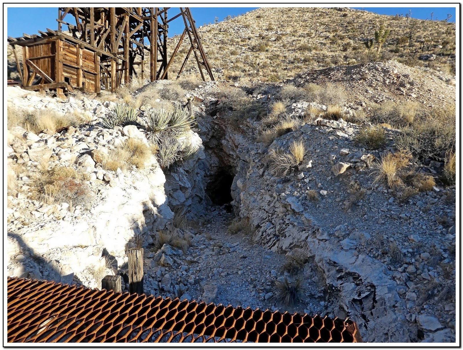
(Fig. 01)

Directions
:
Leaving from the Stratosphere, get on the I-15 South. Go 24 miles and take NV-161 (Exit 12) toward Jean/Goodsprings. Leaving Jean, head west on Route 161 towards Goodsprings. Continue through Ivanpah Valley on the left and Goodsprings Valley on the right, until you reach a unnamed 4WD road opposite the Goodsprings Bypass Road on Nevada 161, about a half mile before Sandy Valley Road. Turn left onto this road. Refer to (Fig. 02). You will be able to see the the Goodsprings Energy Recovery Station in the distance. Keep heading south through the Ivanpah Valley, to a  small, rocky knoll about two miles past the Lincoln Mine. See second map in (Fig. 03).

(Fig. 02)
Area Description: For a more detailed description of the Goodsprings Mining District, go to my page ... Goodsprings Mining District - Summary PageThere are literally dozens of prospects, mines, shafts and adits in the Goodsprings' Mining District in the southern end of the Spring Mountain Range south of the town. The majority of these are accessed from two 4WD roads that run off of Sandy Valley Road and Nevada 161. Table Mountain Road which runs south off of Sandy Valley Road, provides access to, among others, the Surprise, Columbia, Argentena, Lookout and Mountain Top mines.  An unnamed 4WD road opposite the Goodsprings Bypass Road on Nevada 161 runs south through the Goodsprings and Ivanpah Valleys', and provides access to the Crystal Pass Mine, Lincoln, Ireland, Houghton, Star, Monte Cristo, Portor, Accident, Bullion and Valentine mines, as well as dozens more prospects, adits and unnamed mines. The vast majority of the mines in this portion of the Goodsprings Mining District are in the Spring Mountains west of Porter Wash as seen in the (Fig. 03) below.

(Fig. 03)

(Fig. 04) Click to enlarge
Description of the Ireland Mine: The Ireland Mine is a grouping of small prospects, pits, adits, and incline shafts that sit on top of a small, rocky knoll at the mouth of Porter Wash, before the road turns to the right and enters Porter Wash (Fig. 03) and the enlarged cutout of (Fig. 04) right. This large knoll is home to nearly a half-dozen mine sites. All of its mines here appear to have long ago been scoured of any signs of equipment & materials. As with many of the mines in this area, there is little information available that I've been able to find. Within an area scarcely 500 feet in diameter there are 8 shafts and shallow pits, the deepest of which is an incline on the north side of the hill 125 feet deep. The ore shipped from this property has come from small loads of lead, copper, and zinc minerals. According to local reports several carloads of copper-bearing lead ore have been shipped from this site.

12/01/2018 Trip Notes As we approached this rocky knoll we turned right and drove to the north side (Fig. 05). At the end of this short road we parked (Fig. 05) in front of the mine's main opening (Fig. 01). Even though this shaft was barred with heavy steel bars just inside the opening (Fig. 06). The shot in (Fig. 07) was taken peering between the bars. Another nearby tunnel (Fig. 08) allowed one to enter a few feet into it. The pictures in (Figs. 09 and 10) show some nearby wood timbers. The shot in (Fig. 11) is exiting the short tunnel. The view in (Fig. 12) is looking northwest out over the desert in front of these mines. Meanwhile, Jim climbed to some of the pilings higher up on the hillside, but all of them had either been filled or barred. (Con't below)

(Fig. 04)
(Fig. 05)
(Fig. 06)

(Fig. 07)
(Fig. 08)

(Fig. 09)
(Fig. 10)
(Fig. 11)
(Fig. 12)
Notes Continued From here we continued on west into the Porter Wash (refer to Fig. 03). We arrived at an unknown site had what appeared to be the remains of an ore offloading platform (Fig. 13). Due south, opposite was a wash and a hillside that contained several sites of adits with pilings (Fig. 14). Looking west, further up the wash you could see the Accident Mine high on the side of the mountain (Fig. 15). Driving up the wash was not very inviting and we decided to settle for a closeup shot with my 720mm zoom lens (Fig. 16). This mine was located in 1901, Little work was done until 1911, and then again in 1919. The mine has several openings, but most of the ore was produced by the main tunnel. The minerals extracted were gold, silver, copper, lead, and zinc. Lead and zinc were the primarily minerals removed, and the others were beneficial byproducts of the zinc & lead extractions. The main tunnel at this site was actually quite extensive. I wished we had been able to reach it. For more pictures of the site go to ... Accident Mine.

(Fig. 13)
(Fig. 14)
(Fig. 15)
(Fig. 16)

For additional pages on mines around the Goodsprings Mining District also visit the following ... 

Note: Every attempt is made to provide accurate information, but occasionally depictions are inaccurate by error of mapping, navigation or cataloging. The information on this site is provided without any warranty, express or implied, and is for informational and historical purposes only.

Mines in the Mojave National Preserve

{Click on any image to view full size, then use the back button on your browser to return to this page}
This page last updated on 01/03/2019
(Fig. 01) View of Ivanpah Mountains from Morning Star Cutoff Road 

Directions: For this daytrip we gassed up at Primm. Then continued on I-15 and turned left off of I-15 onto Route 164, Nipton Road. After about 3.3 miles we entered the Mojave National Preserve by turning right onto Ivanpah Road. After a few more miles we turned right onto Morning Star Mine Road. We then looked for the Morning Star Cutoff road, an unmarked dirt road on the right, that leads to the Morning Star Mine heading west into the Ivanpah Mountains (Fig 01). This is the second right after entering Morning Star Mine Road.

General Area: There are several mines and audits on both sides of the Ivanpah Mountains, from Morning Star Mine Road on the east side and Cima Road on the west side. There is very little about most of the mines found in the Mojave National Preserve available on the Internet. The map in (Fig. 02) shows the general location of the major mines in and around the Mojave National Preserve. In the past, I have visited the Lucy Gray Mine. It is located in the Gray Mountains of Nevada just over the boundary from California (refer to the top of the map in (Fig. 02). For information and pictures go here ... Lucy Gray Mine. For today's visit, our goal was to find the Morning Star Mine on the east side of the Ivanpah Mountains, the Death Valley Mine, east of Cima, and the Evening Star Mine on the west side of the Ivanpah Mountains off Cima Road.

(Fig. 02)

Side Note: History of the Morning Star Mine: The Morning Star mine is situated on the east slope of the Ivanpah Mountains, north of Kewanee camp, first active in 1907, at which time it appears to have been known as the Clansman mine. Between 1927 and 1933 the deposit was extensively explored. In 1931 two men were employed at the mine. Between 1937 and 1938 Richard W. Malik of Los Angeles optioned the property from the claim owners, J. B. Mighton and H. T. Brown. During Malik's operations 17,000 feet of crosscut drifts were driven and winzes were sunk on the tunnel level. In April, 1939, E. P. Halliburton, owner of the Halliburton oil service company, began operations. Halliburton employed ten men until the property was shut down in 1942 by War Production Board's Order L-208, closing gold mines. The Vanderbilt Gold Corporation acquired the property in 1964, the company drilled and sampled the property. In late 1979 they had raised sufficient capital to begin development. In the early 1980s the Morning Star was reactivated as an underground mine using trackless mining equipment. Ore was processed at Vanderbilt's mill at the site of the 1890s townsite of Vanderbilt, seventeen miles away. The ore was processed by flotation with concentrates shipped for smelting. With the drop in the price of gold, mining ceased in 1982, but exploration by underground long-hole drilling continued. In 1983 the mill circuit was converted to cyanide carbon-in-leach. This allowed dorĂ© bullion to be produced at the mill, eliminating the expense of having concentrates smelted. Drilling during this period established an 8 million ton ore reserve averaging .062 ounces of gold. In the fall of 1984 one million tons of overburden were moved and a $500,000 heap leach facility was constructed. Full-scale leaching began October 1987, and by year end 10,000 ounces of gold and 15,000 ounces of silver had been recovered. Production of ore was 75,000 tons per month. The operation was initially plagued by inadequate water supply, and lower than expected recoveries. This dilemma was solved by abandoning the spray leaching to drip - this doubled the amount of solution leaching through the heap, by using less water. Two heaps were ultimately constructed. The operation suffered from environmental violations including bird and animal deaths in the cyanide ponds, and cyanide solution leaking from the heaps into the adjacent desert. 
 It was in this context of constantly declining gold prices combined with environmental violations due to cyanide poisoning of wildlife and leaking cyanide ponds that Vanderbilt Gold ended operations in 1993. When the Mojave National Preserve was established in 1994 by the passing of the California Desert Protection Act, the newly created park inherited the Morning Star property, as well as its environmental problems. The site was designated a Superfund and cleanup efforts have been slowly implemented at the site since then, though according to the NPS itself "actual mitigation of the hazards could be years away." 

01/03/2019 Trip Notes:  Today's trip consisted of Bob Croke, Ron Ziance and myself. It was a beautiful sunny day with no wind, but cold, in the 40's. We started out driving south on Morning Star Road looking for the Morning Star Mine Cutoff. It is the second road on the right about 8 miles in. We turned right onto this road and followed it uphill to the mine site. As we approached the mine there was a locked gate that prevented us from driving all the way up to the mine area (Fig. 03). From here we had to hike nearly 200 feet up hill for nearly 3/4 of a mile. Once we reached the huge mounds of excavated overage and processed waste it was hard to fathom how huge they were (Fig. 03a). There was a sign on the huge mound on the left indicated that these remains were hazardous to your health. This mound is shown on the right in (Fig. 04). After we reached the top we finally were able to see where of the discharge came from (Figs. 05 thru 07). A huge, deep hole that had been excavated into the mountain side. Walking partway down the road that led to the bottom of the pit we could see some of the colorful ores that had been blasted away (Fig. 08). Hiking back down the road to the car, we could see what appeared to be what was a damaged holding pond that probably contained contaminated processing water that would have seeped into the surrounding water table (Fig. 09). After exploring this mine we then drove to the Death Valley Mine. Refer to the map in (Fig. 10). (Trip notes con't below)

(Fig. 03)
(Fig. 03a)

(Fig. 04)
(Fig. 05) 
(Fig. 06)
(Fig. 07)
(Fig. 08)
(Fig. 09)
(Fig. 10)
Side Note: History of Death Valley Mine: The Death Valley Mine is not in Death Valley California. It is located smack dab in  the middle of the Mojave National Preserve. I could find very little about this mine. Mining the rich lead/silver/gold ore began in 1906 and by 1907 there were 75 employees at the site. Operations slowed from litigation in 1908 until new ownership in 1915. A six-bedroom bunkhouse and ball mill from the 1930’s is still on site. The unique metal head frame is from a 1950's reactivation. An underground survey in the 70's revealed hundreds of bird and squirrel skeletons in the main shaft. Drawn underground by cool temperatures they drank the sulfate laden water. Several structures still remain making for a worthy visit and a decent example of unaltered miners existence. The large rat infested six-bedroom bunkhouse was fairly intact but completely empty. 

01/03/2019 Trip Notes Continued: Again, when we reached the southern end of the property fence line in front of the large six-bedroom house (Fig. 11), there was another locked gate preventing us from driving around the property. The front door to the house was unlocked. When we entered we found that it was in pretty good shape considering its age. We entered what appeared to be a living room with a kitchen to the rear (Fig. 13). There were a couple of rooms off to the right. Opposite the kitchen there was a set of stairs that led up to an attic that contained several bedrooms. Off the kitchen there was an attached room (Fig. 12) that led to a set of stairs leading underground to what appeared to be a root cellar for food storage. Behind the house there were several smaller buildings (Fig. 14). One appeared to be a work shop, one appeared to be a chicken coop. There was also a small coral. Several hundred feet behind the house there was another building that seemed in pretty good shape (Fig. 15). While Bob and Ron went to explore this house, I followed the road to two mines located northeast of the main house. The first mine had an inclined shaft that appeared to go pretty deep (Figs. 16 thru 18). Nearby there was another three-room house that was in pretty bad shape (Fig. 19 &20). There were several pieces of old furniture scattered about (Figs. 21 & 22). A second mine that appeared to be much bigger and deeper (Fig. 23 & 24) was not far away (Figs. 25 & 26). After eating a "bag" lunch we then headed back out and toward the Evening Star Mine. (Trip notes con't below)

(Fig. 11)

(Fig. 12)
(Fig. 13)
(Fig. 14)
(Fig. 15)

(Fig. 16)
(Fig. 17)
(Fig. 18)

(Fig. 19) 

(Fig. 20)
(Fig. 21)
(Fig. 22)
(Fig. 23)

(Fig. 24)

(Fig. 25)
(Fig. 26)
Side Note: History of Evening Star Mine: The Evening Star mine was in production between 1939 and 1944 and was one of the few mines with a crusher on top of the headframe. This mine was the only producer of tin ore in the Mojave Desert. It began life in 1935 as a copper prospect by J. Riley Bembry. Within a year he sold the property to Trigg L. Button and Clarence Hammett of Santa Ana who began sinking the No. 1 shaft. In 1940 Vaughn Maynard of Santa Ana purchased the claims, and in 1941 the Tin Corporation of America leased the property. This company continued sinking the shaft, and shipped 25 tons in June 1942 to the Tin Processing Corporation in Texas City, Texas. In 1943 the mine was leased by Carl F. Wendrick, Jr., owner of the Steel Sales and Service Company of Chicago, Illinois. Wendrick secured a government loan, employed eight men, built a larger headframe, and constructed a mill at Valley wells. Over 400 tons of ore were processed. Several tons of tin concentrates were sold to the government stockpile in Jean, Nevada which contained 35.96 percent tin. Located in the Mescal Mining District, the site maintains an impressive sixty-foot head frame which is built upon three towers of different heights that supplied ore to an ore bin below. The mine is unique in that the crusher is located at the top of the head frame. The structure is essentially sound, and in good condition, however steps have been taken to stabilize the head frame.  The mine shaft itself is closed to access by BLM using a cable net.

01/03/2019 Trip Notes Continued:  There were actually two mine headframes at this site. The first was obviously much smaller than the one at the main mine (Fig. 27). There were however two shafts and a tunnel into the side of the mountain. (Figs. 28 & 30) show the depth of the two shafts here. Both Ron and I entered into the tunnel to look around (Figs. 31 thru 33). We then drove on to the headframe of the main mine (Fig. 34). This is one of the largest I have ever seen. Pictures of this awesome structure can't even capture it size (Figs. 35 thru 37). After the ore was hauled out of the shaft up to the top of the headframe, crushed and then send down it exited at the bottom (Fig. 38). Then below the main shaft, there is another tunnel that went into the side of the mountain (Fig. 39) that seemed like it may have connected to the shaft above and also had yet another deep shaft (Fig. 40). I just can't imagine how much time and effort it took to build this huge headframe (Fig. 42).

(Fig. 27)

(Fig. 28)
(Fig. 29)
(Fig. 30)

(Fig. 31)
(Fig. 32)
(Fig. 33)
(Fig. 34)

(Fig. 35)
(Fig. 36)
(Fig. 37)
(Fig. 38)

(Fig. 39)
(Fig. 40)
(Fig. 41)
(Fig. 42)

     Glossary of Mining Terms       

Note: Every attempt is made to provide accurate information, but occasionally depictions are inaccurate by error of mapping, navigation or cataloging. The information on this site is provided without any warranty, express or implied, and is for informational and historical purposes only.

Return to the preserve summary page ... Mojave National Preserve - Summary Page.