Saturday

Ash Meadows NWR – 11/06/2014 Trip Notes

{Click on an image to enlarge, then use the back button to return to this page}
EFP-P1080712-P1080715
(Fig. 01)
EP-P1080760
(Fig. 02)
Geologic History of the Area: Though it seems hard to envision, thousands of years ago this area was full of large lakes and river systems that were all connected to each other. However, as the climate became hotter, the lakes and rivers began drying up, leaving only isolated springs and small pools and rivers. Most of the water you see bubbling up from these springs today, many at a rate of 2,800 gallons per minute, is the result of rain and snow melt that has traveled from the Spring Mountains, located many miles to the east. The water has been slowly collecting in limestone bedrock for thousands of years, creating deep underground aquifers (Fig. 02). When it runs into underground fault lines it is forced to the surface, creating a natural spring. Warmed by the earth’s geothermal energy, it comes out year-round at a temperature of around 87-degrees.

As temperatures continued to rise over thousands of years, these small desert wetlands caused endemic species (specifically the pupfish) to rapidly evolve in order to adapt to the harsh climatic conditions. In the summer months, much of this fish’s habitat dries up as daytime temperatures can reach 120 degrees Fahrenheit, yet it still thrives, as it has for thousands of years. Known as the Ash Meadows Amargosa pupfish, these fish can live in waters up to 92 degrees and can survive in water that is only a half-inch deep.
                       
11/06/2014 Trip Notes: Even though I had been here on a previous visit, this was the first time that the rock-hounds from the Heritage Park Senior Center has made this a destination. We made our first stop at the Point of Rocks Springs, along the eastern most side of the valley – Note(1). Next we drove out to Devil’s Hole – Note (2). Because you cannot hike down into this area due to the high protective fencing that surrounds it, I found this to be kind of a uneventful stop. Before heading to Crystal Springs, we stopped at the Crystal Reservoir – Note (3), the largest body of water on the refuge. With time running out for our long journey home, we made our last stop of the day at the Refuge Headquarters and Visitor Center next to the Crystal Springs Boardwalk – Note (4). After walking the boardwalk we decided to have lunch in the picnic area next to the visitor center before starting the long ride home. Even though I think that early spring is the best time to visit here - more flowers and birds - today still made for a nice outing.
                                       
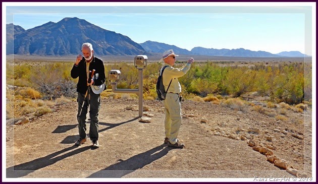
Note (1) - Point of Rocks Springs: Set almost up against the mountains that bound the valley to the east (Fig. 03), its long stream supports a large variety of grasses and vegetation as it runs southward. A meandering 3/4 mile boardwalk follows a relatively long outflow stream that provides a tranquil walk broken only by the sounds of running water and some fluttering birds. Located near the far end of the boardwalk, its vividly colored spring was provided opportunities to view the rare Ash Meadows Amargosa Pupfish (Fig. 04). At the top of the Point of Rocks Boardwalk at the very end of this hike is an amphitheater with telescopes for viewing (Fig. 05). If the timing is right, they give visitors a chance to get a closer look at bighorn sheep and other refuge wildlife.
                      
EFP-P1080683
(Fig. 03)
EFP-P1080693
(Fig. 04)
EFP-P1080710
(Fig. 05)
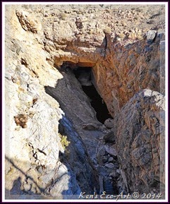
Note (2) - Devil’s Hole: Devil's Hole is a limestone cave located at the base of the mountains on the east-central boarder of the refuge. It is home to the Devil's Hole Pupfish, found nowhere else on earth (Fig. 08). Its spring pool is located approximately 50 feet below the ground surface (Fig. 07) and has a temperature of 93-degrees (F). It descends more than 450 feet into a myriad of mostly unexplored chasms that make up a large underground aquifer. In an effort to protect people and the endangered pupfish surviving therein, Devil's Hole is surrounded by a high steel fence (Fig. 06) to prevent public access. In 1952 President Truman declared Devils Hole, and the rare Devils Hole pupfish, part of Death Valley National Monument. In 1963 the Devils Hole pupfish were officially listed as endangered and was on the very first official listing of endangered species.
                                          
EFP-P1080719
(Fig. 06)
EFP-P1080721
(Fig. 07)
EFP-P1080723
(Fig. 08)
Note (3) - Crystal Reservoir: This large clear body of water has a low earthen dam (Fig. 09) along its western and southern sides. This dam makes for a good, elevated place to walk and look for birds on the water and in the thickets below the dam, although we didn’t see hardly any on today’s visit. Most of our group walked the reservoir’s eastern shoreline (Fig. 10) while I decided to walk along its northern edge (Fig. 11). The view in (Fig. 11) is looking toward the southern end of the reservoir. There are cattails and bulrushes, and a few other shrubs here and there on the northern end of the lake where the waters from Crystal Spring flow into the reservoir.
                                         
EFP-P1080737
(Fig. 09)
EFP-P1080730-P1080731
(Fig. 10)
EFP-P1080729
(Fig. 11)
Note (4) – Crystal Spring Boardwalk: Crystal Spring is a  warm-water pool of clear, blue-green water, maybe 9-10 feet deep and 25 feet across, with a white sandy floor and some bright green algae (Fig. 12). The outflow stream from the spring runs along the .4 mile Crystal Spring boardwalk that leads from the refuge office to the spring through fairly open, fairly flat desert landscape (Fig. 13). The stream, running along the boardwalk is surrounded by a few trees, lots of shrubs, and grapevines as it goes through an open area with scattered screwbean mesquite thickets, various species of desert shrub, and a carpet of saltgrass. The bare areas are covered with a crust of salt, which almost looks like a blanket of snow. Crystal Spring gets its name from the ‘crystal’ clear water that it omits. There is a viewing platform at the spring (Fig. 14) allowing one to take the time to enjoy its beauty and watch the waters as they flow out of the spring (Fig. 15). The changing colors of the trees and shrubs (Figs. 16 & 17) surrounding the spring were a stark contrast to the drab, barren desert that surrounds this area. While walking the boardwalk as it followed the outflow stream we spotted dozens of dragonflies, some crawfish, and a few speckled dance. This outflow runs across the desert down to a point where it feeds into the Crystal Reservoir.
EFP-P1080772
(Fig. 12)
EFP-P1080748
(Fig. 13)
EFP-P1080767
(Fig. 14)
EFP-P1080755
(Fig. 15
EFP-P1080765
(Fig. 16)
EFP-P1080778
(Fig. 17)
Click here to [Return to Previous Page]

Black Canyon Petroglyphs – Trip Notes for 11/19/2014

{Click on an image to enlarge, then use the back button to return to this page}
EFP2-P1080827-P1080828
(Fig. 01)
Black Canyon Petroglyph Site2
(Fig. 02)
Site Description: Generally known as the Black Canyon Petroglyph Site, this 10-acre section of the Pahranagat National Wildlife Refuge was placed on the U.S National Register of Historic Places in 1975 as an archeological historic district having significant potential for information to be learned in the future. Back in 2009, there was an extensive volunteer project that documented over 100 rock art panels at seven sites in and around this location. Black Canyon itself is well-known for its concentration of what is referred to as Pahranagat Representational Style petroglyphs - a distinctive anthropomorph style composed of varying treatments of the human form, often called the Pahranagat Man. It is often a headless rectangular form containing internal decoration accompanied by an atlatl-like design. The body of the anthropomorph is sometimes a solid-pecked oval or somewhat rectangular form with a line protruding from the head and with down-turned arms and extended hands as in (Figs. 16 & 17) below. Because this is a style that is restricted in distribution to the Pahranagat Valley area, it seems to point to a localized cultural development. The representation of atlatls would date some of these petroglyphs to more than a 1,000 years old. Refer to the section below titled, The Atlatl. Overall, the projectile points, sherds, and hydration rim values found during the study reflect an Early Ceramic and Late Archaic use—within the last 1,500 years—with Late Archaic indicators significantly outnumbering Early Ceramic ones, underscoring occupations of Black Canyon within the last 750 years.

Site Habitation: Based upon the rock art found here, it appears that a small band of Pahranagats may have once inhabited this area. Located at the top of the large mound are several circular stone areas that may have once been part of a crude shelter. There is also evidence of grinding slicks that were used for the grinding or crushing of seeds and nuts with a stone.
(Fig. 03)
The Pahranagat Valley lies at the very edge of what is considered as the Fremont "zone". "Fremont" is the name archaeologists have given to a mysterious group of ancient people(s) who lived between 1,500 and 800 years ago. Though centered in Utah and named for its Fremont River, they spilled over into the neighboring states, including Nevada (Fig. 03). These nomadic peoples are often referred to as "hunter-gatherers" because they had to move from place to place following the seasonal ripening of important plants and the migration of game animals, often caused by the rains or lack thereof. The Fremont culture arose here at a time when there was much more water available. When water was available, they actually began to cultivate maize and other plants, becoming more sedentary. Many archaeologists think that the Fremont people may have developed from the Anasazi (Puebloan culture) (Fig. 03). Whether the Fremont people lived in this area or just passed through, still isn't known for sure. Some scholars think that they were forced out by the Southern Paiute. Whatever the case, it is commonly believed that long periods of drought led to the eventual demise of these cultures in the harsh desert areas. These types of harsh conditions such as a lack of food and water would cause people to travel farther to find them. When it became too hot and dry to grow crops, they would have had to abandon the location and go back to being full-time hunters and gatherers. Click here to learn more about this area ... Understanding Nevada Rock Art.

11/19/2014 Trip Notes (2nd visit): Not having enough time to search for more petroglyphs on my last visit here, I decided to visit this area once again, this time with hiking partners Robert Croke and Blake Smith. After getting an early start, we arrived at the site around 9:00 am and were greeted with absolutely beautiful weather, sunny with some partial cloud cover, perfect for hiking and taking petroglyph pictures. Figure 02 above shows the hiking area (in orange) that we covered on this visit. Starting at the southern end of this rather steep rocky hill (Fig. 01), we walked around it east facing side (Fig. 04) looking for easiest route to the top. As we walked around this side of this outcrop we discovered several interesting rock art panels, often located near the very top. The one pictured in (Figs. 05 & 06) show the representation of a man, an atlatl, and a sheep with an atlatl sticking in its back. Climbing further up on a small ledge, we rounded the corner and found another unique grouping of panels (Fig. 07) located just below the ridgeline. Though the top one seems quite crowded with symbols, the three to the right and below it use the pecking of dots to represent what appears to be a bighorn sheep and a man holding an atlatl (Figs. 08 & 09). A little further along we spotted some more panels containing bighorn sheep (Figs. 10 & 11). After reaching the top and enjoying some of the great views (Figs. 12 & 13), including a view of the Upper Pahranagat Lake, we headed to the west (road) side of the mound (Fig. 14) and began searching for the Pahranagat Man panel. (con’t below)
                               
EFP-P1080797-P1080798
(Fig. 04)
EFP-P1080884
(Fig. 05)
EFP-P1080883
(Fig. 06)
EFP-P1080888
(Fig. 07)
EFP-P1080894
(Fig. 08)
EFP-P1080896
(Fig. 09)
EFP-P1080904
(Fig. 10)
EFP-P1080908
(Fig. 11)
EFP-P1080910
(Fig. 12)
EFP-P1080937
(Fig. 13)
EFP-P1080913-P1080914
(Fig. 14)
Upon locating and getting my first look at the Pahranagat Man panel (Fig. 15), I was amazed at how large it was. Standing nearly three feet tall, this is without a doubt one of the largest representations of a human form I have ever seen depicted in a petroglyph panel. In addition to the Pahranagat Man, this split-rock panel contained depictions of several sheep, as well as another anthropomorph holding an atlatl (Figs. 16 & 17). Though we didn’t spot anymore petroglyphs, we did find a grinding slick (Fig. 18) and what appeared to be an area where someone may have built some kind of stone shelter (Fig. 19). After a successful morning of hiking, climbing and picture taking we finally headed to the edge of the hill (Fig. 20) and retraced our steps back to the car, seen in (Fig. 14). Because we still had plenty of time, we decided to drive up the road to Ash Springs and visit the Ash Springs Rock Art Site. Click here for info and pictures on this site ... Ash Springs Rock Art Site.
                                            
EFP-P1080916
(Fig. 15)
EFP-P1080921
(Fig. 16)
EFP-P1080922
(Fig. 17)
EFP-P1080930
(Fig. 18)
EFP-P1080933
(Fig. 19)
EFP-P1080936
(Fig. 20)
The Atlatl: The atlatl was an ancient tool used by the Anasazi (Puebloan) cultures, 1,500-800 years ago, before the invention of the bow and arrow. Atlatl is an Aztec Indian word for spear thrower. It was a shaft which was used as a lever to increase the power imparted to a spear or dart, allowing them to be thrown further and with greater speed and power.

(Fig. 21)
Although details vary, the basic form was a thin, flat strip of hardwood with a hook carved at the end of a groove. It was notched for a split-finger grip and often had a small stone weight bound to the shaft just distal to the finger loops (Fig. 21). The spears or darts were probably made of willow or other light wood armed with a hardwood foreshaft that held a moderate sized stone point. The stone weights are called 'boat stones' or 'banner stone' because of their shapes. Though there are many theories as to what purpose they served, perhaps a counterweight, many believe that it was merely a charmstone, to bring luck to the hunter, though we will never truly know.


(Fig. 22)
Because rock art is not usually full of details or photographically faithful to reality, images of atlatls found in petroglyphs very greatly (Fig. 22). The Atlatl is often depicted as simply a circle with a line through it. Representations of atlatlists in action are surprisingly rare, although some have been found as well at zoomorphs with atlatls sticking out of them. It is actually amazing how many of the petroglyph panels found in the Pahranagat Valley zone contain atlatls, several being attached to the back of a bighorn sheep. Though the atlatls was never thrown, it was probably used to depict just the fact that it was used to throw the spear or dart that brought down the animal.

Pages Uploaded in November 2014

November 2014 Posts (by Category & Title):
Daytrip/Eldorado Canyon - Eldorado Canyon and Nelson NV
Daytrip/Ash Springs - Ash Springs Rock Art Site
UPDATE/Crescent Peak - Crescent Peak Mine Road
UPDATE/Pahranagat DWR - Pahranagat National Wildlife Refuge
Daytrip/Pahranagat - Black Canyon Petroglyphs - Trip Notes for 11/19/2014
Daytrip/Pahranagat - Black Canyon Petroglyphs - Trip Notes for 11/13/2014
UPDATE/Butterflies-Insects - Bee Mania
Black & White - Desert Moonscape
Year in Review - Where Is It?
UPDATE/Ash Meadows - Daytrip - Ash Meadows National Wildlife Refuge
Daytrip/Ash Meadows - Ash Meadows NWR - 11/06/2014 Trip Notes
Plants-Flowers - American White Water Lily (Nnymphaea odorata)
Daytrip/Spring Mt Pass - Mountain Springs Saloon

American white water lily (Nymphaea odorata)

EFP-P1020406
(Fig. 01)
Picture Notes: These pictures were taken 07/28/2013, while on a visit to the Mountain Springs Saloon off highway 160 near the top of the Spring Mountain Pass. Located in the center of a picnic area (Fig. 03) behind the saloon is a small, but quite beautiful lilly pond surrounded by reeds and cat-nine-tails. The pond is even filled with a number of gold fish (Fig. 02).
                              
Description: The American white water lily (Nymphaea odorata) (Fig. 01), a.k.a. Fragrant white water lily, Fragrant water lily, White water lily, Sweet-scented white water lily, Sweet-scented water lily, is from the Nymphaeaceae (Water-Lily Family). It is a floating aquatic plant with large, fragrant, white or pink flowers and flat, round, floating leaves. The leaves have long stems and are bright green above and reddish or purplish underneath. The leaves are more round than heart-shaped, bright green, 6 to 12 inches in diameter with the slit about 1/3 the length of the leaf. Floating on the surface of the water, they are narrowly and deeply cut almost to the center, where the stem is attached. There is 1 flower to a stem, white, fragrant, 2–6 inches across, also floating on the water. Flowers arise on separate stalks, have brilliant white petals (25 or more per flower) with yellow centers. The flowers may float or stick above the water and each opens in the morning and closes in the afternoon. Its seeds, which are produced in large quantities, are smooth and olive-green in color. There are 4 sepals and many rows of white petals, often more than 25, which are between3/4–4 inches long, thick, and pointed at the tip. There are more than 70 bright yellow stamens. The outer ones are large and petal-like; they become smaller toward the center. The quantity of blooms and pads varies per plant, but on average there are 1-2 flowers and 5-7 lily pads. The stomata, tiny openings on the leaf surface through which carbon dioxide and other gases pass into the plant, are on the upper, shiny leaf surface rather than on the lower surface as is the case for most dry-land plants. The leaf stalk, which is soft and spongy, has 4 main air channels for the movement of gases, especially oxygen, from the leaves to the large stems (rhizomes) buried in the muck, which are frequently eaten by muskrats. Though they can be ordered and planted almost anywhere, they are generally native to the northeastern United States, from Canada, south to northwest Maine, and west to northern Michigan and Minnesota and a few places in Washington and Idaho.
                                       
EFP-P1020404
(Fig. 02)
EFP-P1020402
(Fig. 03)

Desert Moonscape

{Click on an image to enlarge, then use the back button to return to this page}
EFP2-P1060063-P1060065
After removing the color, I thought this shot of the valley surrounding the Anniversary Mine Road at mile marker 16 on Lake Mead’s Northshore Road resembled a stark, rocky, barren-like “moonscape”. It is bordered by the Lovell Wash to the south and the Muddy Mountains to the north.