{Click on an image to enlarge, then use the back button to return to this page}
Updated 08/26/2018
 |
| (Fig. 01) |
 |
| (Fig. 02) |
Directions: From the Stratosphere Casino head northeast on Las Vegas Blvd about 3 miles and turn left onto US-93-95, keeping on the left for US-95 North towards Reno. Following US-95 North towards the Mt. Charleston area, drive 36 miles, past SR-156, the turn to Mt. Charleston (Kyle Canyon Rd.) and past SR-156 (Lee Canyon), and head as if driving to Indian Springs. Look for a small green sign on the freeway for Cold Creek (approx. 5 miles past Lee Canyon Ski Area Turnoff). Turn west of the freeway onto Cold Creek Road (SR-172) and drive up the mountain past the prisons (State, Federal, work camps) toward the town of Cold Creek (approx. 13 miles). When you reach the small upper pond, continue onto the dirt Cold Creek Road by turning right. At this junction, the paved road that heads further up into town turns into Cedar Road. From the turn drive .07 miles (green) to the point on (Fig. 02) indicating where we parked. Begin here to walk to the spring.
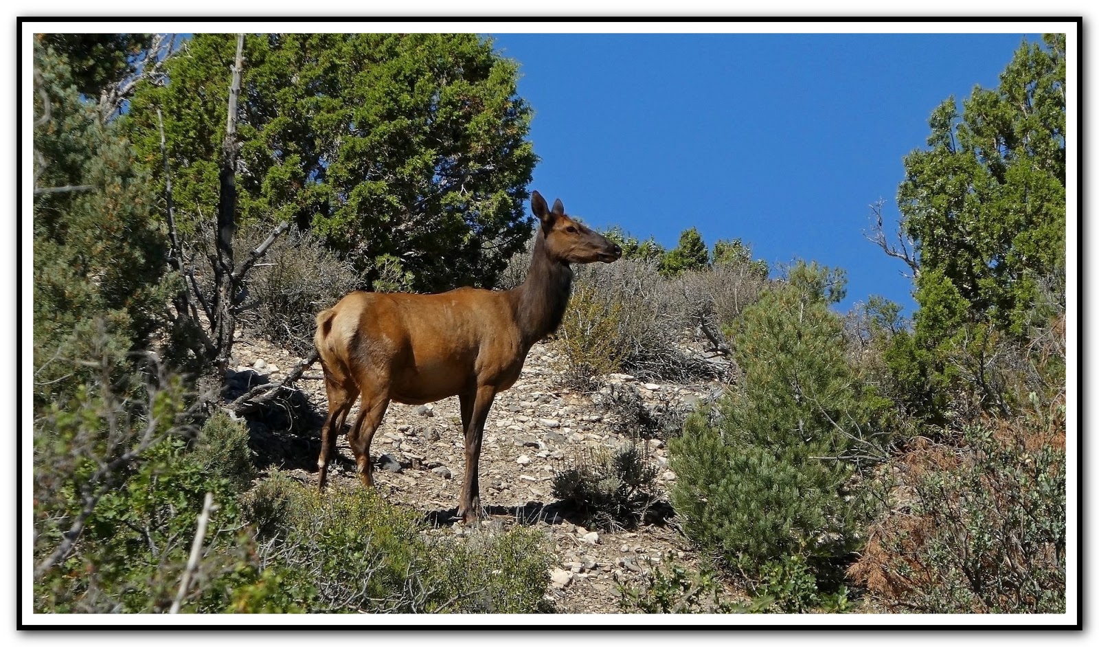
08/24/2018 Trip Notes: Today was a beautiful sunny day with very little wind. Even though this was my second hike of this spot here, it was Jim Herring's first time. At the trailhead at the start of this hike the elevation is around 5,966 feet. The last time I visited here, the first quarter mile of the creek bed was totally dry. On this visit there was a very strong stream of water right from the start (Fig. 01). Today the water was flowing much more than it did on my previous hike. The further we walked up the creek, the more water we encountered. In several places we actually were able to view the mountain range behind the town of Cold Creek (Fig. 03). We also encountered some small waterfalls in the middle of the stream (Fig. 04). Sometimes we walked in the water, sometimes we walked along some of the trails that were on both sides of the wash of the creek. As you can see from these pictures most of this hike was surrounded by heavy shrubs, bushes and trees (Fig. 05). Even though there was plenty of water in the creek, we only encountered a couple of flowers along its banks (Fig. 06). Upon reaching the area of the spring, the elevation is about 6,279 feet, meaning that we climbed nearly 300 feet while following the creek. After reaching the spring at the end of the hike we rested, had a snack and some water. While wandering around we spotted a female elk up on a hill on the west side of the creek (Fig. 07). Zooming in it was evident that she had spotted us as she was staring directly at us. (notes con't below)
 |
| (Fig. 03) |
 |
| (Fig. 04) |
 |
| (Fig. 05) |
 |
| (Fig. 06) |
 |
| (Fig. 07) |
 |
| (Fig. 08) |
 |
| (Fig. 09) |
Notes Continued: Elk (Cervus elaphus), also known as Wapiti, are very large, deer-like creatures. Males stand to 5-ft at the shoulder and weigh up to 1,000 pounds. Antlers are very long (to 65 inches) and wide (spread to 74 inches). Color is tan overall, with white on the rump and chestnut on the head and neck. Antlers are shed in late fall. Females are smaller (to 600 pounds) and lack antlers. In all the hiking I've done over the past six years, this is the first time I've come across an elk. I read that a herd of rocky mountain elk was introduced into the Cold Creek area in the Spring Mountains in the early 1900's where a small herd was managed by the Nevada Division of Wildlife for hunting. In recent years, the herd has grown and spread southward, at least as far south as Mt. Potosi. The area where we spotted this elk must be a popular area as there was elk scat everywhere. With the spring and creek providing plenty of water, elk must feed on the abundant forest-edge vegetation, primarily grazing on grasses and forbs, but they also browse on leaves and bark. After hiking down the creek back to the car (Fig. 10), we then drove northwest along Wheeler Pass Road that leads to the Willow Spring and campground. From a spot in the road there is a great view looking down at the area of Willow Spring, elevation 5,951, and the southwest towards Wheeler Pass (Fig. 11). Walking around the area we were able to see surface water flowing from the spring. Even though we could hear water flowing, due to the thick, overgrown area, it was difficult to get close to the water. Driving back to Cold Creek there is a high spot along Wheeler Pass Road that provides a view to the northeast of the former nuclear testing grounds (Fig. 12). It was just another beautiful day in Nevada.
 |
| (Fig. 10) |
 |
| (Fig. 11) |
 |
| (Fig. 12) |