Showing posts with label Sloan Canyon NCA. Show all posts

Wednesday

Sloan Canyon NCA Hikes - 05/19/2020 Trip Notes

{Click on any image to view full size, then use the back button on your browser to return to this page}
This page last updated on 05/25/2020

(Fig. 01)
Directions: Refer to ... Sloan Canyon NCA -Summary Page
Description of Area: Refer to ... Sloan Canyon NCA -Summary Page
Background and History: Refer to ... Sloan Canyon NCA -Summary Page

05/19/2020 Trip Notes: Today I once again attempted to make the hike to Sloan Canyon with Jim Herring and his daughter Christina. Same as the last time I attempted this hike back on 6 Feb 2020, I was unable to do much more than a mile. Today, due to the COVID-19 the visitor center trailer had been closed and removed from the site. The .07 mile Nawghaw Poa Road leading to the visitor center was barred and locked. We parked on Democracy Drive and walked up Nawghaw Poa Road. About 3/4 of the way up the road we left the road and walked southeast on a trail that led to the old parking area, and then down into the Sloan wash. We then followed the wash to where it interested with the BLM Sloan Trail 100 (Fig. 03 and 04) and then on to the intersection of the BLM Trail 100 and the BLM Trail 200. When Jim and Christina arrived at the intersection, they took Horseman's BLM Trail 200. After reaching the petroglyph area, they returned by taking the BLM Trail 100. The total distance they walked was 6.2 miles.

At this point the wind was guesting greater than 30 mph and I hiked up the stone steps on the side of the wash (Fig. 04) and headed back. I observed dozens of lizards while hiking. I actually spotted several instances of horned lizards (Fig. 05 & 06). (Southern Desert Horned Lizard (Phrynosoma platyrhinos calidiarum) These lizards are so well camouflaged that they are almost impossible to spot (Fig. 07). On the way back, between the festination and the wind guests, I fell forward on my face. I sprained my baby finger and bruised a rib, other that that I was okay. It could have been worse. The last 3/4 of a mile was a bitch.

(Fig. 03)
(Fig. 04)
(Fig. 05)
(Fig. 06)
(Fig. 07)
(Fig. 08)
(Fig. 09)


Note: Every attempt is made to provide accurate information, but occasionally depictions are inaccurate by error of mapping, navigation or cataloging. The information on this site is provided without any warranty, express or implied, and is for informational and historical purposes only.

Sloan Canyon NCA - Summary Page

{Click on any image to view full size, then use the back button on your browser to return to this page}
This page last updated on 05/20/2020
(Fig. 01)

(Fig. 02)

Directions
:
 From St. Rose Parkway, turn south on Executive Airport Drive. Continue straight as Executive Airport Drive turns into Via Inspirada and curves sharply changing into Bicentennial Pkwy. Turn right onto Via Firenze, then turn left onto Savella Avenue. Turn right back onto Via Firenze. Paved road ends at Democracy Drive. Turn right onto Democracy Drive. Follow a short distance until you get to Nawghaw Poa Road is the first paved road to your left. Turn left onto Nawghaw Poa Road. The Sloan Canyon Visitor Contact Station is at the end of Nawghaw Poa Road in .7 miles. Nawghaw Poa means “mountain sheep trail” in Paiute (Fig. 02).

From the south edge of Henderson, Nawghaw Poa Road is accessed from Democracy Drive. For now, the best access is via Bicentennial Parkway and Via Firenze to Democracy Drive. From Democracy Drive. Nawghaw Poa Road runs south and passes through a gate where inbound traffic can be blocked. Outbound traffic can bypass the gate by driving over road spikes when exiting the area after the gate is closed. The paved Nawghaw Poa Road winds up the hillside for 0.7 miles to the parking lot and Visitor Contact Station at the trailhead.  A paved bicycle and walking trail parallels the road. Note that Nawghaw Poa Road is open only when the contact station is open.
 (Fig. 02).

(Fig. 03)
Description of Area:  Formed in 2002, the Sloan Canyon National Conservation Area encompasses 48,438 acres of land managed by the Bureau of Land Management (BLM), located only a short distance south of Las Vegas and Henderson, Nevada in the northwestern portion of the McCullough Mountain Range (Fig. 03). It surrounds an additional area that has been designated as the North McCullough Wilderness Area. The Sloan Canyon Petroglyph Site, found in the south western portion, is the centerpiece of this conservation area. 

Background and History: The Sloan Canyon Petroglyph Site is one of the most significant cultural resources in Southern Nevada. Archaeologists believe its 318 recorded rock art panels with approximately 1,200 individual petroglyphs were created by native cultures from the Archaic to the historic era. Experts believe the earliest of these were made by ancestral Puebloans in the Archaic period, but other tribes may have continued to add petroglyphs in later years. Archaeological evidence suggests resources within Sloan Canyon may have been used as long ago as 7,000 years. It has been called the Sistine Chapel of Native American rock art due to their size and significance. For more information on Sloan Canyon, click the following link ...  Study of Sloan Canyon's Rock Art.
Here is a summary page with more than 50 pictures of rock art that I have taken over the years visiting Sloan Canyon ... Rock Art Photos taken at Sloan Canyon NCA.

Trip Notes: Over the years I have visited this area several times. I believe my first visit was in 2012. Here are the pages with pictures and descriptions of these visits:

___________________________________________________

Note: Every attempt is made to provide accurate information, but occasionally depictions are inaccurate by error of mapping, navigation or cataloging. The information on this site is provided without any warranty, express or implied, and is for informational and historical purposes only.

Friday

Study of Sloan Canyon's Rock Art

{Click on an image to enlarge, then use the back button to return to this page}
This page last updated on 10/11/2017


The Sloan Canyon Petroglyph Site is a National Register-listed property in the Sloan Canyon National Conservation Area, Clark County, NV. In 2006, both the Bureau of Land Management (BLM) and the Nevada Rock Art Foundation (NRAF) studied the area and gathered data for future assessments.

In 1997/98, the Harry Reid Center for Environmental Sciences (HRC) and the Far Western Anthropological Group in 2004, performed an inventory of the site’s rock art and defined its spatial characteristics and established its boundaries. Dividing the site into four sections (Lower Canyon, Middle Canyon, Upper Canyon, and Narrows, identified some 318 rock art panels at the site, distributed over approximately a mile. HRC noted that each section was composed of varying numbers of locations, with the greatest concentration of rock art panels noted in the Middle Canyon and Narrows areas of the site, which are located midway through the canyon. In 2004, Far Western supplemented this record with the identification of 14 additional rock art panels and 7 archaeological features. The results of these archaeological surveys indicate that the Sloan Canyon area has evidence of Middle Archaic, Late Archaic, Puebloan, and Late Prehistoric occupation, mainly connected with resource procurement and processing.


The Sloan Canyon petroglyphs style have been classified as predominantly Basin and Range Tradition in character. Abstract motifs account for about 89 percent of the 1133 motifs present. Circular forms are more frequent motif types than rectilinear designs or variants of lines. In terms of numbers of panels, though, these three broad forms occur in roughly equal quantities, but variants of lines are slightly less common. In general, there is little spatial variation across the site in the distribution of abstract motif types; i.e., discrete spatial patterning in the occurrence of the three broad abstract types is not discernible.

Some specific abstract motif types are, however, localized in their distribution. So-called “necklace” designs (two nested arcs outlined by a row of dots that follows the contour of the outer arc) are found only in Upper Canyon I. Possible “atlatl” representations are rare, but seem to be concentrated in Middle Canyon I. If these really are schematic “atlatls,” then this might indicate a Middle Archaic date for some rock art production at that location.

Overall, the abstract imagery at the site exhibits a tendency to open forms, sometimes with other motifs inside. Its opaque references probably encouraged ambiguity in the cultural interpretations attached to it by its users, perhaps indicating that it functioned to provide an exegetic space for the expression of competing social narratives, a common function of visual symbolism. Alternatively, it may have had very specific cultural meanings for its users, meanings that an external observer cannot “read” based simply on a visual consideration of its properties.

Some art may be more performative in its motivation than other types. Simple vertical lines, usually occurring singly, account for about 10 percent of all motifs at the site. As these are not related to other design elements they may be related to practices where leaving a mark was the main motivation. Figurative forms tend to evoke greater interest from modern observers of rock art, largely because their apparently representational nature gives us a false confidence that we can identify its subject and cultural references. These motif types also bear the burden of style definitions in rock art studies as stylistic variation is easier to recognize in forms for which the apparent theme or subject can be identified.

Representational forms are statistically a small component of the Sloan Canyon rock art assemblage, only about 11 percent of all motifs but approximately 23 percent of all panels. Anthropomorphs outnumber zoomorphs in the number of panels in which these are present, but zoomorph motifs are slightly more frequent than anthropomorphs. In general, anthropomorphs tend to be represented singly in contrast to zoomorphs, a greater proportion of which are depicted with other zoomorphs.

Most zoomorphs and anthropomorphs at the site are of types that are not culturally specific. Two anthropomorphs are historic in character as they appear to be wearing cowboy hats and one is apparently holding a rifle. One other anthropomorph may be historic in age as it is depicted apparently riding a quadruped. These historic motifs may be important records of early contact between Native Americans and Euro-Americans. The remaining anthropomorphs at the site predominantly are Basin and Range Tradition stick-figure anthropomorph types.

Although the archaeology of Sloan Canyon NCA documents the presence of Puebloan, Patayan, and Southern Paiute peoples (among others), these cultural identities seem to be only weakly expressed through the site’s rock art. If the rock art did function to construct and communicate cultural identities with external groups, it did this in a way that we cannot apprehend through its motif assemblage. Some rock art is directly associated with milling features and the general archaeological context of the site’s art is one of resource acquisition and procurement, and temporary habitation for task-specific purposes. The informing context in which prehistoric populations would have used and encountered the site’s rock art is one of daily economic and social routines.

The art is generally not in spaces that can be considered private (other than the few panels that are up high above the canyon floor and that are difficult to access) and largely is placed in natural traffic corridors or activity areas. Therefore, it is likely that Sloan Canyon’s rock art negotiated and expressed social identities experienced in the routines of daily social life. The art may have been used in a cultural discourse that allowed people to reflect on the lived experience of social and domestic routines, providing a physical embodiment of a social memory that transcended individual experience.

The information on this page comes from the Nevada Rock Art Foundation’s report on the Sloan Canyon National Conservation Area that was completed in the winter of 2007 - ref <http://www.nvrockart.org/pages/Sloan.htmlThe Nevada Rock Art Foundation, 641 Jones St, Reno, NV 89503 / PO Box 35892, Las Vegas, NV 89133; Tel. 775.323.6723 / 702.804.6723


Sloan Canyon NCA - 01/21/2016 Trip Notes

/ {Click on an image to enlarge, then use the back button to return to this page}
This page last updated on 05/25/2020
(Fig. 01)
(Fig. 02)
Directions: From St. Rose Parkway (NV-146), turn onto Executive Airport Drive. At the intersection (light) of Volunteer Blvd and Via Inspirada, continue straight onto Via Inspirada. This road then curves left onto Bicentennial Parkway. About 2.3 miles from St Rose Pkwy, turn right onto Via Firenza and go to the end. At the junction of Democracy Road, turn right and bypass the barrier onto a dirt road. Work your way west toward the main power line. Follow the power line until you see a two-track dirt road on your left, just before pole number 12084. Follow this road south for approximately 1 mile to a cleared parking area (Fig. 02). From here exit the parking area on the east side walk to the Sloan Canyon Wash. Then hike to the original trailhead and the entrance of Sloan Canyon. A high clearance vehicle is recommended to reach the parking circle.

(Fig. 03)
General Description: Formed in 2002, the Sloan Canyon National Conservation Area (shown in green on Fig. 03) encompasses 48,438 acres of land managed by the Bureau of Land Management (BLM), located only a short distance south of Las Vegas and Henderson, Nevada in the northwestern portion of the McCullough Mountain Range. It surrounds an additional area that has been designated as the North McCullough Wilderness Area. The Sloan Canyon Petroglyph Site, found in the south western portion, is the centerpiece of this conservation area. The Sloan Canyon Petroglyph Site is one of the most significant cultural resources in Southern Nevada. Archaeologists believe its 318 recorded rock art panels with approximately 1,200 individual petroglyphs were created by native cultures from the Archaic to the historic era. Experts believe the earliest of these were made by ancestral Puebloans in the Archaic period, but other tribes may have continued to add petroglyphs in later years. Archaeological evidence suggests resources within Sloan Canyon may have been used as long ago as 7,000 years. It has been called the Sistine Chapel of Native American rock art due to their size and significance. For more information on Sloan Canyon, click the following link ... Sloan Canyon National Conservation Area.

(Fig. 04)
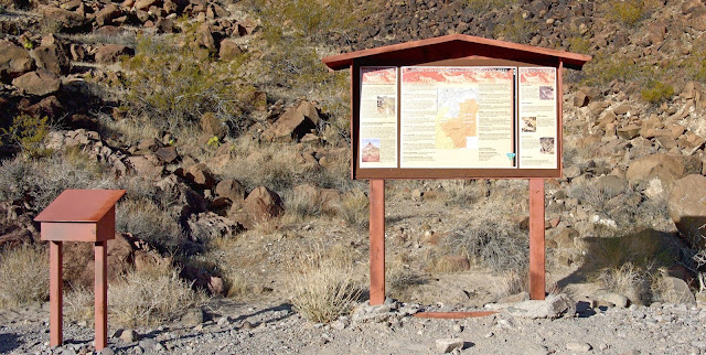
01/21/2016 Trip Notes: On this third visit to this area, I tagged along with the rock-hounds from Henderson's Heritage Park Senior Center. From the parking circle, considered by some the trailhead, the trail runs east into Sloan Wash and the beginning of BLM 101 Trail that turns upstream (south) following the wash. In about 0.6 miles, the trail arrives at the historic trailhead (Fig. 05), passes around the cable fence, and passes through the old boulder barricade to the trail information sign (Fig. 01). The sign provides a map of the trail and information about the area. Beyond the trail sign, the route continues up the gravel wash in a fairly narrow, shallow canyon. After a minute or two, the canyon widens and the sides lay back (Fig. 06). At 0.64 miles out from the trailhead register and kiosk (Fig. 01), a side wash on the west merges with Sloan Canyon Wash. This confluence is marked with a trail sign indicating that the HorseTrail (BLM 200 Trail) turns right, out of Sloan Canyon Wash, and runs up the side canyon. Note that the Horseman's Trail is suitable for horses and does not require any scrambling, although it is about 3/4-miles longer to the petroglyph gallery. The BLM Trail 100 continues straight ahead up the wash to the petroglyph gallery. Half of our group took the trail to the right and the other half of the group continued straight ahead. Taking the BLM Trail 100 involves navigating a series of 3-4 pour-overs like the ones seen in (Figs. 07 & 08). At about a mile out you encounter the largest non-trivial (3rd-class) water-polished 10-foot pour-over to climb. This pour-over has a very large boulder stuck between the outer walls of the canyon (Fig. 09) Though somewhat intimating, it isn't too bad if you are willing to climb up on the most exposed part. (con't below)

(Fig. 05)
(Fig. 06)
(Fig. 07)

(Fig. 08)
(Fig. 09)
Trip Notes Continued: Just above the 10-foot pour-over, the canyon jogs back to the south (left) and widens considerably. The view in (Fig. 09) is actually looking back towards the pour-over. This straight section of wash is the area known as the Sloan Canyon Petroglyph Gallery. There are amazing petroglyphs on both sides of the canyon here. The rocky strewn hill on the west side of the wash is loaded with thousands of boulders with many containing anywhere from one to more than a dozen glyphs. As we walked up and down the wash, some of us took to climbing up the sides of the hill (Figs. 10 & 11) in order to obtain better pictures of petroglyphs. The collage in (Fig. 12) is just a sampling of the dozens of petroglyph pictures I've taken here. Click here to view more 50 petroglyph pictures ... More Petroglyph Pictures From Sloan Canyon. It seemed the more we explored, the more we found. The find by the two ladies in (Fig. 13) shows a rare petroglyph of what appears to a be person riding either a horse of donkey. At this point, some in the group returned by hiking back via the BLM Trail 200. About six of us opted to "slide" down the pour-over that we climbed on the way up. The picture in (Fig. 14) is a staged picture of me after I descended the pour-over on a previous visit. Today, Robert Croke (Fig. 15) volunteered to lead the way. The picture in (Fig. 16) is a view looking down at Sloan Canyon Wash from the top of the pour-over. After descending the slippery pour-over, it was pretty much easy going the rest of the way back to the trailhead and the parking circle. Click here for more pictures and descriptions of my previous visits to Sloan Canyon ... Previous Visits to Sloan Canyon. I'm sure that I've still only seen less than 20% of the petroglyph rock panel found at this site. I will definitely return again and do some more "investigating".
                                           
(Fig. 10)
(Fig. 10)
(Fig. 11)
(Fig. 12)
(Fig. 13)
(Fig. 14)
(Fig. 15)
(Fig. 16)
(Fig. 17)
11/21/2013 Trip Notes: On this visit to this area we approached the area from Bicentennial Parkway. Not only was this a much shorter, easier route, it was accessible by our van. Once we reached the beginning of the road leading to the trailhead, we followed the road about 1.1 miles to the actual trailhead. We then began the 1.1 mile hike up the loose gravel filled wash to the petroglyph area. Stopping short of the actual site, I detoured up the lower portion of the “loop trail”, BLM Trail 200. View Previous Visits to Sloan Canyon

02/21/2012 Trip Notes: I made this trip with Harvey Smith, one of the regular rock-hound hikers, who volunteered the driving with his new 4x4 truck. The drive along the power line access road was extremely rough and required the four-wheel drive in a couple of spots. Once we reached the trailhead which starts at the beginning of the North McCullough Wilderness Area, the hike up the loose gravel filled wash to the petroglyph gallery was relatively easy, excepting the climb up the last of the three wash-overs. View Previous Visits to Sloan Canyon

Sloan Canyon NCA Hikes - 02/21/2012 Trip Notes

{Click on an image to enlarge, then use the back button to return to this page}
This page last updated on 05/0232020

EFP-P1050326
(Fig. 01)
(Fig. 02)
(Fig. 03)
Directions: Because this hike was back in 2012, a lot has changed in the area surrounding Sloan Canyon. Since this hike several new roads and hundreds of houses have been built in this area of town. As you can see from (Fig. 01) there was nothing but desert and dirt roads. Back then, coming from St Rose Parkway, you turned onto Executive Airport Drive. At the intersection (light) of Volunteer Blvd and Via Inspirada, continue straight onto Via Inspirada. This road then curves left onto Bicentennial Parkway. About 2.3 miles from St Rose Pkwy, turn right onto Via Firenza and go to the end. At the junction of Democracy Road, turn right and bypass the barrier onto a dirt road. Work your way west toward the main power line. Follow the power line until you see a two-track dirt road on your left, just before pole number 12084. Follow this road south for approximately 1 mile to a cleared round parking area. From here you exited the parking area on the east side and walked to the Sloan Canyon Wash. Heading due south, you then hiked to the original trailhead and the entrance of Sloan Canyon. 

Description of Area:  Formed in 2002, the Sloan Canyon National Conservation Area encompasses 48,438 acres of land managed by the Bureau of Land Management (BLM), located only a short distance south of Las Vegas and Henderson, Nevada in the northwestern portion of the McCullough Mountain Range (Fig. 02). It surrounds an additional area that has been designated as the North McCullough Wilderness Area. The Sloan Canyon Petroglyph Site, found in the south western portion, is the centerpiece of this conservation area.

Background and History: The Sloan Canyon Petroglyph Site is one of the most significant cultural resources in Southern Nevada. Archaeologists believe its 318 recorded rock art panels with approximately 1,200 individual petroglyphs were created by native cultures from the Archaic to the historic era. Experts believe the earliest of these were made by ancestral Puebloans in the Archaic period, but other tribes may have continued to add petroglyphs in later years. Archaeological evidence suggests resources within Sloan Canyon may have been used as long ago as 7,000 years. It has been called the Sistine Chapel of Native American rock art due to their size and significance. The rock art in Sloan Canyon is primarily of the Great Basin and Range tradition with abstract elements accounting for the majority of the rock art panels found in the canyon. Anthropomorphs (human-like) and Zoomorphs (animal-like) appear in about equal numbers throughout the canyon.  Most of the anthropomorphs and zoomorphs are traditional stick-like figures that are not culturally specific. Some of these have been dated to be more than 900 years old. However, there are two known exceptions to these common stick-like petroglyphs, both of which are historic figures. One appears to be a cowboy holding a rifle and the other appears to be a cowboy riding a horse.  It is believed that these may depict contact between Native Americans and early American pioneers during the westward movement. For more information on Sloan Canyon, click the following link ...  Study of Sloan Canyon's Rock Art. Here is a summary page of more than 50 pictures of rock art that I have taken over the years visiting Sloan Canyon ... Rock Art Photos taken at Sloan Canyon NCA.

Paragraph divider

11/21/2013 Trip Notes: On today’s visit to this area we approached the area from Bicentennial Parkway. Not only was this a much shorter, easier route, it was accessible by our van. Once we reached the beginning of the road leading to the trailhead, We then began the 1.1 mile hike up the  loose gravel filled wash to the petroglyph area. we followed the road about 1.1 miles to the actual trailhead. Just beyond the trailhead (Fig. 03) I walked up the wash to the top of a ridge behind the Kiosk. When I reached the top of the ridge, it provided me with a good view of the wash and Sloan Canyon as it began to narrow on its way to the petroglyph gallery (Fig. 04). As a result, had to return back down to the wash. By then I ran out of time and I never did make it to the site of the petroglyphs on today’s visit.
EFP-P1050332
(Fig. 04)
Paragraph divider

02/21/2012 Trip Notes: I made this trip with Harvey Smith, one of the regular rock-hound hikers, who volunteered the driving with his new 4x4 truck. The drive along the power line access road was extremely rough and required the four-wheel drive in a couple of spots. Once we reached the trailhead which starts at the beginning of the North McCullough Wilderness Area, the hike up the loose gravel filled wash to the petroglyph gallery was relatively easy, excepting the climb up the last of the three wash-overs.

(Figs. 05 & 06) shows the approach to the third and most difficult of the three scramble ups that we encountered. As you can see in (Fig. 06), there is a huge boulder stuck right I the middle between the two cliff edges. Climbing up the right side, which Harvey chose, was quite steep and then required a jump of nearly 12 feet after you reached the top to get back down to the base of the wash. Climbing the left side, which I opted for, shown in (Fig. 08), was much shorter, however the face of the rocks were as smooth as glass, making it extremely difficult to get any footing. This “staged” photo was taken after my decent on our return trip, showing what it would probably have looked like if Harvey hadn't been there to assist me. (Fig. 07) is a shot from the top of this impediment, looking back down the canyon's narrows. The petroglyphs in (Figs. 09 thru 14) are but a few of the hundreds of ancient etchings in this area. The picture in (Fig. 13) shows harvey hiking near the top of the canyon in the petroglyph area. (Notes continued below)

E-P1100284
(Fig. 05)
E-P1100285
(Fig. 06)
E-P1100190
(Fig. 07)
E-P1100279
(Fig. 08)
E-P1100184
(Fig. 09)
E-P1100250
(Fig. 10)
E-P1100259
(Fig. 11)
E-P1100275
(Fig. 12)
E-P1100253
(Fig. 13)
E-P1100231
(Fig. 14)
Notes Continued: After taking dozens of petroglyph pictures in the main gallery area, we continued hiking further up Sloan Canyon wash and a couple of side trails for what was probably another mile and a half. Finding nothing more than a few scenic views, we started our return to the trailhead. The three pictures below (Figs. 15-17) are some of the views we observed in this upper area. (Click here for more ... More Sloan Canyon Petroglyphs).

(Fig.15)
(Fig. 16)
(Fig. 17)
                              
E-P1100295
(Fig. 18)
After leaving the Sloan Canyon National Conservation Area we decided to turn east on the power line road and look for an alternate route out vice going back over the same rough route we took in. After tough four-wheel climb, we reached the highest point in the power line road next to Seven Hills (Fig. 18). The view in (Fig. 19) is looking back toward the "M" Casino. Using his binoculars, Harvey spotted what looked like a possible way out which led us to a place where we were able to “sneak” onto Bicentennial Parkway, just south of the Henderson Airport. Great job Harvey!

(Fig. 19)