Saturday

Death Valley National Park - Summary Page

{Click on an image to enlarge, then use the back button to return to this page}
This page last updated on 03/06/2019
E-IMG_2852E-IMG_2851
EP-P1060163-2Billie Mine: Located in the center of the main borate mining district of Death Valley, just outside of Death Valley National Park, the now shut down Billie Mine was one of the largest Borax mines in the Ryan District. The actual national park boundary runs along the west side of the wash and road here, making both the Billie Mine site and the abandoned mining town of Ryan visible in the near distance to the south just outside of the national park. However, the shafts of the Billie mine ended up running under and into the Death Valley National Park.
                
EP-P1060120-2The Ghost Town of Ryan: Ryan Company Town is one of the best preserved ghost towns and mining camps in the state of California. This ghost town epitomizes what the “Old West” was all about. Built in 1914, it was a company mining town built in a remote and rugged area on the side of a steep mountain on the eastern edge of Death Valley National Park that served several borax mines. Its railroads, the Death Valley Railroad and the Baby Gauge Railroad, transported the Borax ores out of the area for processing.
                             
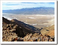
EP-P1060133-P1060135-2Dante's View: Dante's View is a viewpoint terrace at 5,476 feet on the north side of Coffin Peak, along the crest of the Black Mountains. Overlooking Badwaater Basin and the inferno of Death Valley, it is without doubt, the most breathtaking viewpoint in the park. Both of Death Valley’s elevation extremes, Badwater Basin at 282 feet below sea level and due west to Telescope Peak, 11,049 feet above sea level, can be seen in a single glance.


E-P1030309 Stitch-220 Mule Team Drive: The area surrounding the 20 Mule Team Drive was created by the remarkable effects of wind, rain and erosion, this scenic drive through multicolored badlands, situated in the old Monte Blanco mining district, provides views of the stunning topography of Twenty Mule Team Canyon in Death Valley. It is a one-way, single lane road through the northern end of the Black Mountains, it goes through the Death Valley badlands area; an area of quickly eroding, soft mud mountains which were actually once the bottom of a seasonal lake a long time ago.
                                                                  
Zabriskie Point - Badland Loop Trail: This past week, Blake Smith, Robert Croke, Ron Ziance and I decided to drive to Death Valley National Park to hike the Badland Loop trail at Zabriskie Point. Zabriskie Point itself is an elevated overlook of a colorful, undulating landscape of gullies and mud hills at the edge of the Black Mountains, just a few miles east of Death Valley. The Badland Loop trail is a 2.2 mile hike that puts hikers right in the center of some of the most desolate, barren terrain on earth. 
                                    
E-IMG_2851-2Furnace Creek Area: This link to the “Furnace Creek Area” is a summary page that encompasses additional links with pictures and information on many of the area’s better known sites, including but not limited to: 20 Mule Team Canyon, Zabriski Point, Harmony Borax Works, Borax Museum, Golden Canyon, Artists Drive, Devil’s Golf Course, Natural Bridge Canyon, Badwater, and the Ashford Mill Ruins.


You can view pictures of some of the wildflowers I’ve captured at some of these sites at the following page …   Death Valley National Park Flora.


Play a Slide Show
Clicking the picture-link below will open OneDrive in a new window and a folder containing 165 pictures taken on various trips to the Death Valley National Park. To view the show, click on the first picture in the folder and you will get the following menu bar:

Clicking the "Play slide show" will play a fullscreen window of the slide show.


___________________________________________________

Note: Every attempt is made to provide accurate information, but occasionally depictions are inaccurate by error of mapping, navigation or cataloging. The information on this site is provided without any warranty, express or implied, and is for informational and historical purposes only.

Aztec Tank – Trip Notes for 02/20/2014

 {Click on any image to view full size, then use the back button on your browser to return to this page}
This page last updated on 04/18/2018
EFP-P1060699
(Fig. 01)
About 10 miles behind the town of Goodsprings Nevada, Aztec Tank is a deep wash at the south eastern foot of the Mount Potosi Range. It is reached by following Pauline Mine Road, which runs parallel to a large red Aztec sandstone outcrop located at the end of the Goodsprings Bypass Road. Using the beginning of Pauline Mine Road as a trailhead (Fig. 01), it is about a two mile hike to the area of Aztec Tank. Shortly after we started hiking, I noticed a fairly large rock (Fig. 02) in the middle of the road that contained just dozens of what appeared to be fossilized coral. As we continued hiking up this road, we also passed what was one of the largest “collection” of tumbleweed (Fig. 03) that I have ever encountered.  About halfway out there is a large tan sandstone outcrop, visible in (Figs. 01 & 10). Unfortunately, it wasn't until we were back at the Goodsprings Pioneer Saloon having lunch that we learned that it contained a grouping of ancient petroglyphs. We will have to explore this more on a future hike.
                                 
EFP-P1060694
(Fig. 02)
EFP-P1060697
(Fig. 03)
After a couple of miles, we headed east onto Aztec Road (Fig 04). This road climbs up the large sandstone ridge and then runs along Aztec Tank wash, located several hundred feet below (Fig. 05). At one time this whole area was quarried for its beautiful sandstone. We spent considerable time hiking along this road, studying the unique geology (Fig. 07) and enjoying the beautiful views in every direction (Figs. 06 & 08). At one point we were even able to capture a glimpse of Las Vegas way off in the distance. After we finished hiking through the old quarry area (Fig. 09), we began a return hike, down the west side of the sandstone ridge and back out to Pauline Mine road (Fig. 10), and back to our starting point. Once we reached the van, those who had stayed back pointed out some wild horses that were way off in the distance. Using my 480mm zoom, it was hard to get a good handheld picture (Fig. 11).
                        
EFP-P1060720
(Fig. 04)
EFP-P1030388
(Fig. 05)
EFP-P1060716
(Fig. 06)
EFP-P1060712
(Fig. 07)
EFP-P1060714
(Fig. 08)
EFP-P1060727-P1060728
(Fig. 09)
EFP-P1060729-P1060730
(Fig. 10)
EFP-P1060743
(Fig. 11)

Badwater Basin - Death Valley National Park

{Click on an image to enlarge, then use the back button to return to this page}
This page last updated on 02/09/2018
EFP-P1060189
(Fig. 01)
MAP-Death Valley National Park-2
(Fig. 02)
Directions: From the Stratosphere Casino head southwest on S Las Vegas Blvd toward W Baltimore Ave. Travel 1.7 miles and turn right onto Spring Mountain Rd. Go .7 miles and turn left to merge onto I-15 South. Follow for 5.4 miles and take exit 33 to merge onto NV-160 W/Blue Diamond Rd/State Route 160 W toward Pahrump. Continue to follow NV-160 W/State Route 160 West for 55 miles  In Pahrump, continue straight on Hwy. 160 through three stoplights then drive 3.1 miles. Turn left at Bell Vista Road and continue 25.5 miles to Death Valley Junction. Turn right and then immediately left on CA Hwy 190 and drive 30 miles to Furnace Creek Junction. Badwater Basin is on the west side of CA 178 (Badwater Road), 17 miles south of the Furnace Creek junction and highway 190.
                         
Area Description: The sign near the parking area says that the area was named Badwater because a traveler was coming through and saw that there was water for his mule to drink; however, because the water is so full of salt the mule refused to drink it and thus the name Badwater was born. Several salt trails and shallow seasonal streams lead towards other pools out across the valley. During occasional rainy periods, a large shallow lake forms, several miles across and only a few inches deep. “Each newly-formed lake does not last long though, because the 1.9 inches of average rainfall is overwhelmed by a 150 inches annual evaporation rate. This, the United States’ greatest evaporation potential, means that even a 12-foot-deep, 30-mile-long lake would dry up in a single year.” However, Badwater never dries out completely, and even manages to support a unique species of fish - the Death Valley pupfish, a small bluish creature which has evolved to survive in the hot saline conditions. Far above this, the overlook at Dante’s Peak has imposing views over Badwater and the surrounding desert.
                               
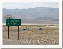
01/27/2014 Trip Notes: Located right in the heart of the Death Valley National Park, no trip to Death Valley would be complete without a stop at Badwater Basin, the lowest point in North America. On this, my third visit to the park, I was accompanied by my friend Jim Herring from Wichita Kansas (Fig. 01). From the parking lot you can see the sea level sign that is located 280 feet above you on the adjacent mountain. It really puts in perspective how low you are when you see it compared to the mountain. Click to enlarge and look for the arrow in the middle of the photo in (Fig. 03). After viewing the sea level sign, head down to the boardwalk which leads to a small pool of water and the salt flats. Here you will find a sign (Fig. 01) indicating that this location is 282 feet below sea level. Just to the right is Badwater pool (Fig. 04) (depending upon the time of year). Looking beyond the pool, you are greeted with a massive lake of what looks like snow. However, instead of snow, it is the left over salt from evaporated water. With Telescope Peak, elevation 11,049 feet, the highest point in Death Valley in the background, these salt flats stretch almost 5 miles across, as far as the eye can see (Fig. 05). The view of Badwater in (Fig. 06) showing some people walking out to the center of the basin, was taken several miles past the parking area at Badwater.
                                    
EFP-P1060196
(Fig. 03)
EFP-P1060191
(Fig. 04)
EFP-IMG_2881 Stitch
(Fig. 05)
EFP-IMG_2885
(Fig. 06)

Click here to [Return to the Previous Page]

Mouse’s Tank - Site Petroglyphs Photos

                                        {Click on an image to enlarge, then use the back button to return to this page}
EFP-P1050616
(Fig. 01)
Valley of Fire: Valley of Fire State Park is home to one the largest concentrations of petroglyphs in the state of Nevada. It is very likely that some ofthe Valley of Fire petroglyphs had been created over a period of roughly 3,000 years, by members of several different cultural groups. The situation becomes more complex when the representational figures at the site are examined. You will see bighorn sheep, but also deer and, especially, human motifs on the panels at Mouse Tank. Although these kinds of motifs are similarly present in the hunter-gatherer art of the Far West, the Puebloan examples tend to be more systematically stylized and formulaic than seen in California and the Great Basin. This is particularly true of the human figures: the idiosyncratic "patterned-body anthropomorphous" that typify Numic rock art, for example each of which displays a unique internal body design composed of entoptic patterns are replaced by smaller, solid-body humans, many of which are identical or near-identical in form in the Puebloan art. The near carbon copy duplication of particular motifs, then, is a trend in Puebloan rock art, contrasting with the more idiosyncratic renderings of a set of motifs in the hunter-gatherer art.
             
 
(Fig. 02)

There is no better illustration of this than the panel of human and animal petroglyphs and entoptic designs at the site. Particularly notable is an ensemble of four human figures, holding hands and standing in a line (Fig. 02). The two figures on the right are shown with thin, straight torsos and waists; those on the left are blocky, rounded, and almost obese. What is most interesting in this case is that precisely the same motif ensemble is present elsewhere on the site: four humans holding hands, with two thin figures on the right and two blocky figures on the left. The implications of this repetition of complex images are straightforward, the first being the existence of formalized and organized religious beliefs and practices, removed from the more idiosyncratic nature of the individualized shamanistic practices of hunter-gatherer groups. At the Mouse Tank petroglyphs, as well as those at Atlatl Rock, we see an expression of what are presumably formal religious cults and rites such as those still practiced by Pueblo groups today, rather than simply the practices of a lone shaman or a few ritual initiates.

Mouse’s Tank: Mouse's Tank, which is also called Petroglyph Canyon Trail, is a 1/2 mile round-trip hiking trail off White Domes Scenic Drive. From the trailhead, just of the parking area, the trail heads in a due southeast direction (Fig. 01).  A trail that is filled with very fine red sand, is surrounded by red rock cliffs and bee hive shaped mountains.  Many of the rock faces along the trail are covered with desert varnish, a naturally occurring dark patina that forms on the surface of rocks in the desert, making the perfect palate for the native peoples who lived in the area more than a thousand years ago.
                                 
Petroglyph History at Mouse’s Tank(1): The Mouse Tank Petroglyph Trail consists of an impressive series of panels located along a short trail to a deep depression in the rocks that collects and stores water seasonally. Like Atlatl Rock, Mouse’s Tank falls within a region that was occupied by Puebloan farmers during the period from approximately AD 1 to 1200 and, like this first site, Mouse’s Tank contains many Puebloan style petroglyphs. Indeed, Mouse’s Tank appears to be more purely Puebloan in age than the Atlatl Rock, which includes motifs of pre-Puebloan, Puebloan, and post-Puebloan or Numic ages. The Mouse Tank Trail affords a rare opportunity to view a kind of site in southern Nevada that typically would require traveling to Arizona or southern Utah to see.
                              
The interpretation of Puebloan rock art is, at this point, still problematic. Southwestern farming cultures suffered great disruptions at approximately AD 1200, a time of significant drought resulting in the abandonment of many sites and, in certain cases, entire regions, including the Valley of Fire. EP-P1050617
No one is certain of the implications these disruptions may have had for religion and belief, although it is likely that there were major changes in these facets of culture. Thus, we cannot easily use recent ethnography from the Hopi, Zuni, or the Rio Grande Pueblos to interpret the pre AD 1200 Puebloan rock art. EP-P1060361
That said, there are nonetheless a few points that can be made to give us some understanding of the Puebloan petroglyphs. The first concerns their prehistoric link with the hunter-gatherer art of California and the Great Basin. In both cases these two art traditions derive from a shared older archaic substrate of religion and belief. EP-P1060350
We have every reason to assume that this substrate was shamanistic; in fact, there continue to be shamanistic elements in Puebloan religions, thereby affirming their shamanistic origins. Furthermore, we know that one of the characteristics of these archaic shamanistic practices was the making of rock art. Some aspects of Puebloan rock art, therefore, are likely to be shamanistic in origin and intent. EP-P1060342
This last supposition is well supported by the art, especially with reference to the neuropsychological model of motif forms that derive from altered states of consciousness, discussed in the introduction. At Mouse Tank we see many, if not all, of the entoptic patterns that are common precepts in the first stage of a trance. They include zigzags, meandering and parallel lines, patterns of dots and circles, spirals and concentric circles, and nested curves, as well as more complex combinations of these geometric forms. The presence of this suite of entoptic motif types makes it unlikely that they derive from sources other than altered-states mental imagery. EP-P1060349
However, as I have emphasized a number of times, this inferred fact concerning the origin of the art tells us little about the cultural meaning of the motifs. For example, although the recent ethnography provides us with an understanding of the intended meaning of spirals and concentric circles in the Far West whirlwinds, the concentrators of supernatural power, and the shaman's ability to fly it is simply unknown whether or not the whirlwind interpretation of this entoptic pattern might also apply to Mouse Tank's Puebloan rock art. EP-P1060362
The situation becomes more complex when the representational figures at the site are examined. You will see bighorn sheep, but also deer and, especially, human motifs on the panels at Mouse Tank. Although these kinds of motifs are similarly present in the hunter-gatherer art of the Far West, the Puebloan examples tend to be more systematically stylized and formulaic than seen in California and the Great Basin. EP-P1060345
This is particularly true of the human figures: the idiosyncratic "patterned-body anthropomorphous" that typify Numic rock art, for example each of which displays a unique internal body design composed of entoptic patterns are replaced by smaller, solid-body humans, many of which are identical or near-identical in form in the Puebloan art. The near carbon copy duplication of particular motifs, then, is a trend in Puebloan rock art, contrasting with the more idiosyncratic renderings of a set of motifs in the hunter-gatherer art. EP-P1060341
There is no better illustration of this than the panel of human and animal petroglyphs and entoptic designs at the site. Particularly notable is an ensemble of four human figures, holding hands and standing in a line. The two figures on the right are shown with thin, straight torsos and waists; those on the left are blocky, rounded, and almost obese. What is most interesting in this case is that precisely the same motif ensemble is present elsewhere on the site: four humans holding hands, with two thin figures on the right and two blocky figures on the left. EP-P1060341
The implications of this repetition of complex images are straightforward, the first being the existence of formalized and organized religious beliefs and practices, removed from the more idiosyncratic nature of the individualized shamanistic practices of hunter-gatherer groups. At the Mouse Tank petroglyphs, as well as those at Atlatl Rock, we see an expression of what are presumably formal religious cults and rites such as those still practiced by Pueblo groups today, rather than simply the practices of a lone shaman or a few ritual initiates. EP-P1060337
Second, it is then unlikely that the figurative images are all necessarily depiction's of spirit helpers, and other spirits and beings, in the supernatural world. Instead, they may represent deities, mythic actors, ritual participants, and so on, with the potential meaning of this Puebloan art a reflection of the more formal and structured nature of Puebloan religion relative to that of the hunter-gatherer. EP-P1060335
(1) This information was taken from “A Guide to Rock Art Sites of Southern California and Southern Nevada” by David S. Whitely.
Click here to [Return to Previous Page]

Little Finland (Gold Butte)

{Click on an image to enlarge, then use the back button to return to this page}
Little Finland Image
(Fig. 01)
MAP-Little Finland-3
(Fig. 02)
02/05/2014 Trip Notes: Looking at the map above (Fig. 02), we came from the upper left corner of the map (red route) and tried to approach Little Finland by going up Red Spring Wash. In addition to the wash being very wet and sandy,the area was filled with some rather large, rocky ledges (Fig. 03 & 04) that prevented us from going any further. Our attempt ended where it says, “Washed out Road” on the map. Heading back from here we ended up driving down Gold Butte Wash (Fig. 02). Several miles down the wash we missed a turn and ended up traveling south on what was labeled”Back Country Byway” for several miles. After we finally realized our mistake, we turned around again and headed back north and found where we had missed the turn. Unfortunately, by this time it was getting rather late and we had to try and find our way back to our original starting point. Because we never made it to Little Finland, I copied the picture in (Fig. 01) from the Internet. Hopefully on my next visit I will be able to replace this with some of my own. On our next visit, we will approach this area from the opposite direction, either going up Mud Wash Road or Mud Wash itself. Shown in yellow on the map in (Fig. 02). About the only good thing that came out of this was that we located some more really great petroglyphs (Fig. 05 & 06)on our return while driving up Mud Wash Road.
                           
EFP-P1060543
(Fig. 03)
EFP-P1060542
(Fig. 04)
EFP-P1060562
(Fig. 05)
EFP-P1060557
(Fig. 06)

Click here to [Return to the Previous Page]