Showing posts with label Valley of Fire. Show all posts

Tuesday

Fire Wave (VOF) - 02/16/2019 Trip Notes

 {Click on an image to enlarge, then use the back button to return to this page}
This page last updated on 02/18/2019
(Fig. 01)
(Fig. 02)
(Fig. 03)
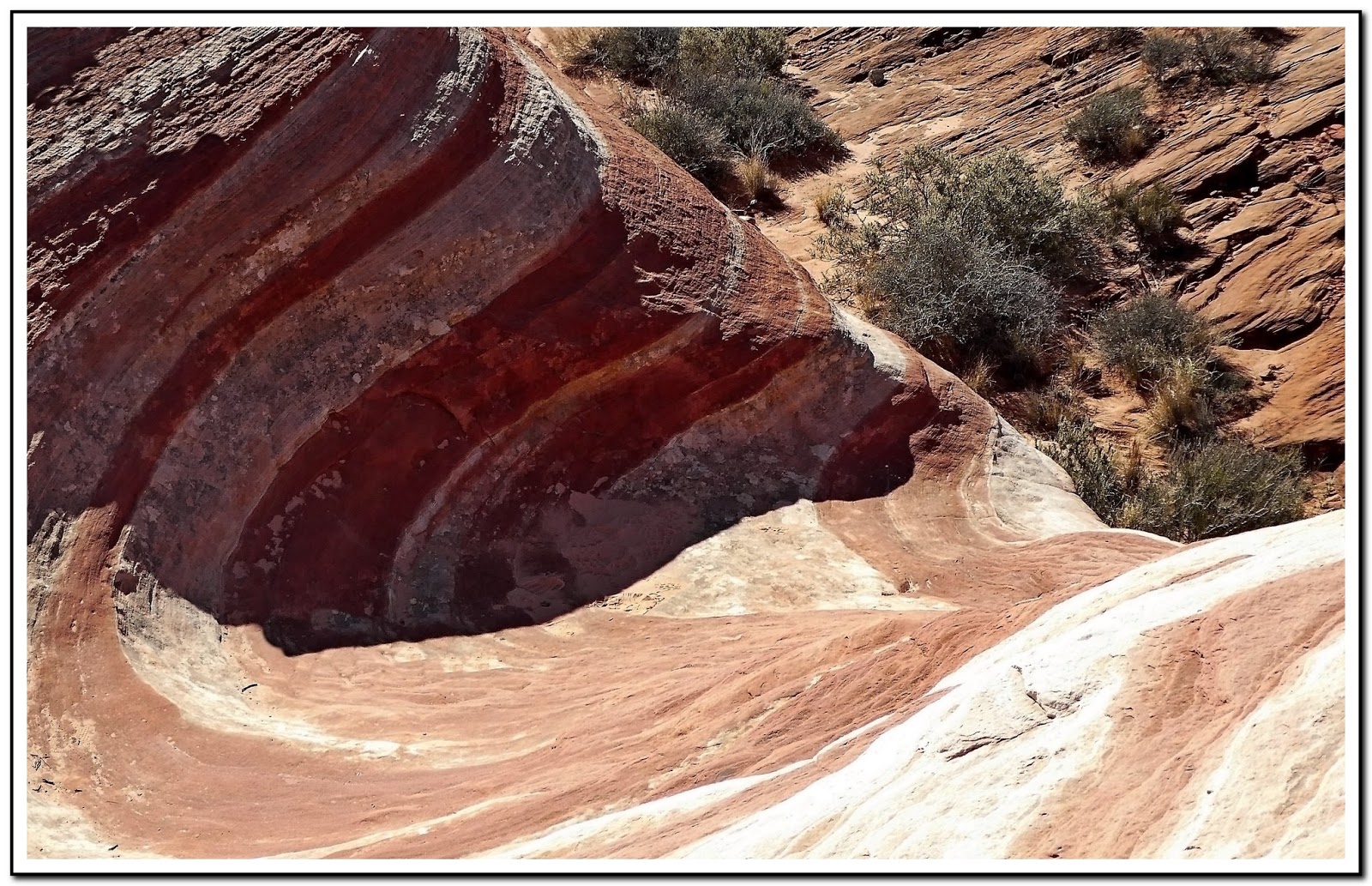
02/16/2019 Hike Notes: On the way to the parking lot opposite Gibraltar Rock, every turn as you drive through Rainbow Vista Valley presents you with gorgeous jaw dropping views of the colorful desert found at Valley of Fire State Park (Figs. 01-03). Even upon reaching the parking lot, the trailhead for our hike, you are surrounded with beautiful views within only a few walking feet from your car (Figs. 04 & 05). The shot in (Fig. 06) shows Cynthia Pace and Bob Croke getting a rundown of the hike from our guide, Rosa Prasser, Park Interpreter for Nevada Division of State Parks, Valley of Fire State Park. After less than a couple of hundred feet you find yourself at the base of the western side of Gibraltar Rock (Fig. 07). As we rounded the southern tip of Gibraltar Rock we stopped along the way while our guide provided demonstrations on how the sandstone formations were created and discussed some of the vegetation that we passed along the way (Fig. 08). (Notes continued below)

(Fig. 04)
(Fig. 05)
(Fig. 06)
(Fig. 07)
(Fig. 08)
(Fig. 09)
Notes Continued: As we approached and climbed up the smooth rock surfaces on the way out to the wave, there was some standing water from the previous days rains (Fig. 09). This was the first time I had ever encountered water anywhere along this trail. Looking to the west from where the trail led, you could see the many colored sandstone and rocks that covered this area (Fig. 10). Before we knew it we were looking down onto the fire wave (Fig. 11). Unfortunately, due to the numbers in our group and all the others that had hike to the "wave" it was almost impossible to take a shot without someone or their shadow being in the picture. I actually had to remove people or shadows from each of the pictures in (Figs. 12 thru 14). After hiking back to the trailhead, we stopped at Silica Dome for a few quick shots. In picture (Fig. 15) Bob was explaining to Cynthia how we had hiked down into "fire canyon" (Fig. 16) on a previous hike (Silica Dome). However the highlight of our day was the spotting of nearly 20 desert bighorn sheep just past Mouses's Tank canyon on our way to the visitor center (Fig. 17). Click here for pictures ... Desert Bighorn Sheep - Summary Page.

(Fig. 10)
(Fig. 11)

(Fig. 12) Click to Enlarge
(Fig. 13) Click to Enlarge
(Fig 14) Click to Enlarge
(Fig. 15)
(Fig. 16)
(Fig. 17)
(Fig. 18)

Saturday

Petrified Logs at Valley of Fire

{Click on an image to enlarge, then use the back button to return to this page}
This page last updated on 11/13/2018
(Fig. 01)
Directions: There are two petrified log sites in the park. To get to the site on the west side of the park (refer to Fig. 01) ... from Las Vegas, take Interstate 15 north for about 35 miles to exit 75 (signs for Valley of Fire State Park and Lake Mead National Recreation Area). At the end of the offramp, proceed southeast on Valley of Fire Highway. Go through the park’s west entrance after 14.5 miles and drive an additional 1.8 miles to an intersection where Scenic Loop Road (Campground Road) parts to the left. Turn right up a gravel trail, following the sign for Petrified Logs. Drive another 0.2 miles to the parking lot and trailhead at the end of the road.

Area Description: There are short trails that lead to petrified logs at each of the locations shown on the map in (Fig. 01). Though we hiked near the site on the west end of the park, we didn't take the marked trail used by the general public.  The logs are several colorful tree trunks lying close to the road, safely fenced off for all to enjoy. There are two fenced in logs along the trail on the site at the west site. The site on the east end of the park has one large petrified log that is fenced in.  Today we joined a park ranger for an hour and a half guided hike among petrified logs in a nearby area near the west end site surrounded by a large, locked, fenced in area that is not open to the general public.


Description of Petrified Wood: Petrified wood (from the Greek root Petro meaning "rock" or "stone"; literally "wood turned into stone") is the name given to a special type of fossilized remains of terrestrial vegetation. A wide variety of names are commonly used for petrified wood. "Fossilized wood" is a general term for wood that has been petrified or preserved by other methods of fossilization. "Opalized wood" is petrified wood that has been replaced by opal, an amorphous form of silica. "Agatized wood" is wood that has been replaced by agate, a form of chalcedony or microcrystalline quartz. "Silicified wood" is wood that has been replaced by any form of silica, including opal and agate. Petrified wood is a fossil and is generally thought to be 225 million years old. It forms when plant material is buried by sediment and protected from decay due to oxygen and organisms. Then, groundwater rich in dissolved solids flows through the sediment, replacing the original plant material with silica, calcite, pyrite, or another inorganic material such as opal. The result is a fossil of the original woody material that often exhibits preserved details of the bark, wood, and cellular structures. The brilliant colors in the petrified wood come mainly from three minerals. Pure quartz is white, manganese oxides form blue, purple, black, and brown, and iron oxides provide hues from yellow through red to brown. The three pieces shown in (Fig. 01a) below, were all captured today while walking around this area.
(Fig. 01a)


11/10/2018 Trip Notes: Ron Ziance, Bob Croke and myself joined about 12-14 others (Fig. 02) for a guided tour of an area of petrified logs that is off limits to the general public. After we left the meetup area we hiked above a long wash (Fig. 03) before descending down into the wash itself. Eventually we came to a locked gated along the fence that surrounded the area. Once inside we walked around and climbed a hillside (Fig. 04) that was just loaded with thousands of pieces of varying sizes of petrified wood. There were  many places where you could observe long sections of trees (Figs. 05 & 06), though they were "broken", almost appearing like they had been sawed. Pieces of petrified wood were just everywhere (Fig.07). I spotted a rock that had what looked like a branch from a tree that was actually embedded into a rock (Fig. 08). The picture in (Fig. 09) is Ron Ziance at the end of one of the longest logs. The view in (Fig. 11) is looking back down the hill and across the valley below. If you click on the picture to enlarge it you can see the fence and wash in the middle of the picture. (See pictures and notes below from the log at the other site shown on the map in (Fig. 01).

(Fig. 02)
(Fig. 03)
(Fig. 04)
(Fig. 05)
(Fig. 06)
(Fig. 07)
(Fig. 08)

(Fig. 09)
(Fig. 10)
More Notes: The pictures below (Figs. 11 thru 14) were taken of the fenced-in petrified log at the site on the east end of the park (Fig. 01) on a visit I made back in 2011.

(Fig. 11)
(Fig. 12)
(Fig. 13)
(Fig. 14)

Tuesday

Natural Arches Trail (VOF) - Trip Notes for 09/08/2017


 {Click on an image to enlarge, then use the back button to return to this page}
This page last updated on 09/09/2017

(Fig. 01)


(Fig. 02)


(Fig. 2a)


DirectionsIf you arrive from the east, from the intersection of Route 169 and 167 near Lake Mead, drive west on the Valley of Fire Highway for two miles to the park’s east entrance. Then drive another 1.7 miles to the trailhead for the Natural Arches Trail. If you want to start from The Cabins, drive 2.1 to the entrance road. To reach the park from the west from Las Vegas, take Interstate 15 north for about 35 miles to exit 75 (signs for Valley of Fire State Park and Lake Mead National Recreation Area). At the end of the off-ramp, go southeast on Valley of Fire Highway. After 14.5 miles you reach the park’s west entrance. Drive another 4.8 miles and turn left, following a sign for The Cabins, or approximately 5.5 miles to the Natural Arches Trailhead (see Fig. 2a).

(Fig. 03)
Trail Description:  The parking lot is on the north side of the main park road just west of a large wash between the road to "the cabins" and Elephant Rock. Park in the gravel lot, look for the tiny trailhead marker near the road, and head down into the wash. The total distance for this (in-out) hike is 4.80 miles. The elevation at the trailhead is 1,592 feet. The total net gain in elevation is 229 feet. This trail is not marked anywhere along the way, but it is easy to follow as it just follows the main wash the entire way. Walking on the canyon's soft pink/white sand floor requires a bit more effort, but the lack of significant vertical rise makes up for that. The wide wash narrows considerably after about a mile, and there are three small rock scrambles to navigate.
(Fig. 04)
With each turn of the canyon the shapes and colors of the rock continue to amaze. Keep an eye open for arches, as there are several along the route. The largest arch (Fig. 03 right), for which the trail was named, succumbed to erosion and collapsed several years ago. Unfortunately, the picture in (Fig. 04 right) is a view of all that remains. In spite of this, the main features of this trail remain: extreme solitude and incredible desert beauty. The hiker can turn back anywhere on the route, but there is a huge balancing rock at 2.4 miles that offers shade and a natural turning point.


09/08/2017 Trip Notes: Today Bob Croke, Jim Herring and I drove to the Valley of Fire State Park to hike the Natural Arches Trail. Though our initial plan was to start this hike from The Cabins (see Fig. 02), one of the park's rangers convinced us to use the hikes primary trailhead. At the Natural Arches trailhead (refer to Fig. 02) there are two large culverts that run under the park's main road (Fig. 05). As we started this hike the sky was very grey and filled with threatening rain clouds. From here we began the "trudge" up the very sandy wash. In the beginning the wide sandy wash was filled with a variety of plants, shrubs and trees as seen in (Fig. 06). The further we hiked, the less was the vegetation and the deeper was the sand (Fig. 07). Though hiking in the still quite soft sand, a recent rain had caused the sand to be somewhat packed. As time went on, the sky began to become less threatening and even had some areas of blue sky (Fig. 08). Occasionally we would encounter plants in the middle of the wash (Figs. 09 & 10). (notes con't below)

(Fig. 05)
(Fig. 06)
(Fig. 07)
(Fig. 08)
(Fig. 09)
(Fig. 10)
Trip Notes Continued:  On batch of these plants we filled with dozens Tarantula Hawks (Figs. 11 & 12). Click here to learn more ... Tarantula Hawk Wasp (Pepsis species). The soft sands of the wash caused us to take many stops along the way (Figs. 13 - 15). In some places we encountered areas where we sunk more than six inches into the sand. Even though we never did locate the location where the original arch collapsed several years before, we did observe nearly a half dozen smaller arches along the way (Figs. 16 & 17). Near where we thought the remains of the fallen arch, we found what others have described as a large balancing rock (Fig. 18). All the way up the wash we get encountering what we guessed were foot prints of bighorn sheep that kept   crossing the wash. On the return hike back we finally saw three sheep run across the wash about a hundred yards in front of us. Using our telephoto lenses, we were able to get off a half dozen shots (Figs. 19 & 20). After a very grueling six mile hike, we considered this was the highlight of the hike. (Fig. 21) is a picture of a bee that was also sipping on the flowers where we saw the Tarantula Hawks.

(Fig. 11)
(Fig. 12)
(Fig. 13)
(Fig. 14)
(Fig. 15)
(Fig. 16)
(Fig. 17)
(Fig. 18)
(Fig. 19)

(Fig. 20)


(Fig. 21)

Return to the Summary Page ... Valley of Fire State Park - Summary Page.