{Click on an image to enlarge, then use the back button to return to this page}
This page last updated on 02/08/2018
 |
| (Fig. 01) |
Directions: South Cove is about 110 miles from Henderson. Driving on US 93 South through Boulder City, over the Mike O'Callaghan – Pat Tillman Memorial bridge, cross into Arizona and drive approximate 50 miles before turning left onto Pierce Ferry Road at the Dolan Springs, Meadowview, Pierce Ferry exit. It is then about 49 miles to the South Cove. Turn left and follow the paved road to South Cove just before the road turns into a graded gravel road for the remaining five miles to Pierce Ferry Landing. (Refer to Fig. 02)
 |
| (Fig.02) |
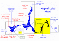 |
| (Fig. 03) Click to Enlarge |
South Cove Picnic Area & Boat Launch Description:
Located on the eastern most edge of Lake Mead shown in (Fig. 02) South Cove is in only a very small section of Lake Mead. The area shaded in yellow on the map in (Fig. 03) shows the section in (Fig. 02). The road to the right above the boat parking takes you to South Cove picnic area. There is paved parking and two brick outhouses. There are two covered picnic areas with picnic tables and barbecues. The collage in (Fig 05) shows us gathered around our picnic table. The view in (Fig. 01) was taken looking west from our picnic table. If you continue straight the road leads to a large parking area at the top of the hill before you descend down to the launch ramp (Fig. 04). The boat launch ramp was widened and extended for more boat traffic. South Cove is a picnic area and a boat launch site. Pierce Ferry, 4 miles further northeast by road, lies beside the Colorado River, and is the point where the Grand Canyon begins (or ends)(Fig. 03).
 |
| (Fig. 04) |
 |
| (Fig. 05) |
02/08/2018 Trip Notes: Today Harvey Smith, Bob Croke, Jim Herring and I took a ride to South Cove in Arizona for a picnic and day of hiking. The Pierce Ferry Road to South Cove and Pearce Ferry Landing is 52 miles long, starting from US 93 half way between the Hoover Dam and Kingman. This is a interesting drive that passes by much dramatic scenery and several places of interest. The first 8 miles are across the flat Detrital Valley, through Dolan Springs - a typically scattered desert town with isolated houses surrounded by a large selection of broken vehicles and old pieces of machinery, all rusting away under the sun. The local general store is worth a visit as it stocks every conceivable item and has a good collection of western memorabilia.
 |
| (Fig. 06) Click to Enlarge |
Beyond the town of Doland Springs the road climbs into the White Hills and then across the Hualapai Valley. Joshua trees begin to appear and grow steadily thicker eastwards, and around the hills at the far side of the valley. At elevations of 4,000 feet, they grow as densely as anywhere in the Southwest (Figs. 06 & 07). The trees are large, old and well-branched, and the whole spectacle is even more impressive than the Joshua Tree National Park in California. Just before the main concentration of trees, the Pearce Ferry road meets with Antares Road, a long dusty track linking with old Route 66. As the main road climbs, and the Joshua trees are replaced by various species of cacti - several types of spiny opuntia, clusters of echinocacti and large barrel-shaped ferocacti. A side road forks east, passing through rocky, uninhabited land to the Quartermaster Viewpoint, a high plateau overlooking the Lower Granite Gorge, part of the western end of the Grand Canyon. It then meets the Buck and Doe Road that links Peach Springs with Grand Canyon West, where the Hualapai operate the Grand Canyon Skywalk, a projecting walkway over the canyon which has become by far the main tourist attraction of the Hualapai Indian Reservation. Further along the main road there is more scattered habitation until it reaches a spot that is about 5 miles from the edge of Lake Mead. Here the paved road turns left towards South Cove.
 |
| (Fig. 07) |
Trip Notes Continued: The four mile road to South Cove and the edges of Lake Mead descends 1,475 feet, winding its way through some unique cliffs. At the end of the road there are several parking lots, a large paved boat launch (Figs. 08 & 09) and a picnic area with covered picnic tables, grills and stone outhouses. This cove is located in the middle of an area of Lake Mead known as the Gregg Basin, some of the best water at the east end of Lake Mead. Glass conditions are almost guaranteed in the morning and expected in the late afternoon in the East Lake area. But even at mid-day with moderate wind you can always find coves and channels that are vacant and sheltered to accommodate smooth water-play. There are a couple of reasons for such nice water. First, fewer people visit this part of the lake because of it's remote location. Second, the higher cliffs of the mountains can protect the water from potential wind. It's definitely the place to go to water-ski, camp on the lake, or sightsee, especially if you're staying more than a weekend. The fishing is good too! Anyone that knows the area will tell you it's the best kept secret on the lake. In the 4-5 hours we spent there we observed at least 6 boats that were out on the lake, one right below where we were eating lunch (Fig. 10). Before we had lunch, we all spent time hiking around the shoreline (Refer to Fig. 08), in and out of some of the smaller inlets and coves (Figs. 11 - 13). The water views were absolutely beautiful. (con't below)
 |
| (Fig.08) |
 |
| (Fig. 09) |
 |
| (Fig. 10) |
 |
| (Fig. 11) |
 |
| (Fig. 12) |
 |
| (Fig. 13) |
Trip Notes Continued: The view, courtesy of Robert Croke in (Fig. 14), was captured at a "scenic overlook" pullout on the way to South Cove. You could even see the snow on top of Mt. Charleston more than 90 miles away. Even though we did not drive on to Pierce Ferry Landing on today's visit, continuing ahead on Pierce Ferry Road, the surface becomes unpaved and the track descends quite steeply along a dry, sandy valley (prone to flash floods) towards Pierce Ferry Landing and the waters edge. Pierce Ferry is the final destination for raft trips down the lower Grand Canyon, particularly those run by the Hualapai Indians, which depart from near Diamond Creek at the end of Peach Springs Canyon in the morning and emerge late afternoon onto the calm waters of the lake after around 8 hours sailing. The rafts pass in front of the high red cliffs that form a backdrop to the east end of the lake, and which are particularly striking at sunset. For pictures and to read more about Pierce Ferry click here ...
Pierce Ferry Landing.
 |
| (Fig. 14) |


