
Monday
Slideshow of Flower Pictures
Ref - Shrinking of the Gold Butte National Monument
Zinke recommends shrinking Gold Butte National Monument
Published Tuesday, Dec. 5, 2017 | 1:07 p.m.
Updated Tuesday, Dec. 5, 2017 | 3:59 p.m.
Designated for government protection less than a year ago, Gold Butte National Monument could shrink in size significantly at the recommendation of Interior Secretary Ryan Zinke.
In a report issued Tuesday, Zinke recommends downsizing the nearly 300,000-acre monument “to ensure that the monument reservation is limited to the smallest area compatible with the protection of the objects identified and protect historic water rights.”
The report follows a months long review of 27 national monument designations initiated by Zinke and President Donald Trump.
Zinke’s recommendations do not specify how much land should be removed from the monument, but he calls for prioritization of “public access, infrastructure upgrades, repair, and maintenance; traditional use; tribal cultural use; and hunting and fishing rights.”
Zinke said the administration is working with Gov. Brian Sandoval and the Nevada congressional delegation to find a solution.
"The Department of Interior's decision is welcome news for Nevada as it allows the Valley Water District to access their water rights that were lost under the previous administration," said U.S. Sen. Dean Heller, R-Nev., who added he was proud to work with Zinke "to prioritize local concerns over the opinion of Washington bureaucrats."
But Brian Beffort, director of the Sierra Club's Toiyabe Chapter in Nevada, said the secretary's recommendation "is a direct attack on decades of work invested by local communities."
President Donald Trump signed a pair of proclamations Monday shrinking the Bears Ears and Grand Staircase-Escalante national monuments in Utah.
"The administration is engaged in the largest rollback of national monuments protection in recent history," Rep. Jacky Rosen, D-Nev., said today.
Zinke's review of the monuments "has been a sham from the start, failing to listen to local advocates and tribal communities in Nevada who care deeply about preserving the natural beauty and cultural heritage of Gold Butte," she said. "I will continue to fight this reckless decision."
Last December, former President Barack Obama set aside the large swath of land northeast of Las Vegas at the urging of former Sen. Harry Reid and local conservationists, who long sought protection for the area filled with sandstone formations and ancient petroglyphs.
Gold Butte is northeast of Las Vegas, between Lake Mead National Recreation Area and the Grand Canyon—Parashant National Monument.
Zinke traveled to Nevada to visit Gold Butte in July. He canceled a meeting with advocates of the monument and Rep. Dina Titus, D-Las Vegas. Titus, a longtime supporter of Gold Butte, decried Zinke’s recommendations.
“If he were interested in the will of Nevadans, Zinke would know that Gold Butte’s designation was the product of grassroots advocacy, good-faith negotiations, and the belief that our natural treasures should not be subject to the Trump Administration’s blatant disregard,” Titus said. “We must continue to fight, on the ground and in the courts, to protect Nevada’s piece of the Grand Canyon.”
The Associated Press contributed to this report.
Pygmy Rabbit (Brachylagus idahoensis)
{Click on an image to enlarge, then use the back button to return to this page}
This page last updated on 03/26/2018
 |
| (Fig. 01) |
Picture Notes: All of the pictures on this page were taken at the Floyd Lamb Park in Las Vegas. Figure 01 was captured on 9 February 2016. The remaining pictures were taken on 12 February 2018. On this last visit there were more and a dozen of the furry little animals.
 |
| (Fig. 02) |
Description: The pygmy rabbit is the smallest rabbit species in North America and can fit in the palm of a hand. Their average weight is 0.827 to about 1.102 lb. Their body length is from 9.3 to 11.6 inches; females are slightly larger than males. As you can see from (Fig. 03), their fur color varies from brown to dark grey with white around the margins of their short, round ears. Their ears and feet are densely covered in hair and they have a very short tail, 15 to 24 mm. The pygmy rabbit is one of only two rabbit species in America to dig its own burrow. Burrows are dug in deep loose soil and are extensive, with multiple, interconnecting chambers. They also use natural cavities and the burrows of other animals. Burrows have several entrances, usually at the bases of large sagebrush shrubs. Tunnels widen below the surface, forming chambers, and extend to a maximum depth of about 3.3 feet. Burrows typically have 4 or 5 entrances but may have as few as 2 or as many as 10. Pygmy rabbits use a system of runways between food plants, both above ground in the summer and below the snow in winter. Pygmy rabbits use burrows more in the winter for thermal cover than at other times of the year. In areas where soil is shallow pygmy rabbits live in holes among volcanic rocks, in stone walls, around abandoned buildings, and in burrows made by badgers and marmots. They move by scampering close to the ground and generally don’t leap. Pygmy rabbits are normally in areas on deep soils with tall, dense sagebrush which they use for shelter and food. Individual sagebrush plants in areas inhabited by pygmy rabbits are often 6 feet or more in height. Extensive, well-used runways interlace the sage thickets and provide travel and escape routes. Weasels are the principal predators of pygmy rabbits. Coyotes, red foxes, badgers, bobcats, great horned owls and marsh hawks also prey on pygmy rabbits. The range of the pygmy rabbit includes most of the Great Basin and some of the adjacent intermountain areas of the western United States. Pygmy rabbits are found in southwestern Montana from the extreme southwest corner near the Idaho border north to Dillon and Bannack in Beaverhead County. Distribution continues west to southern Idaho and southern Oregon and south to northern Utah, Nevada, and eastern California.
 |
| (Fig. 03) |
Back to ... Floyd Lamb Park - Trip Notes for 02/12/2018.
Kingman Arizona - Summary Page
{Click on an image to enlarge, then use the back button to return to this page}
This page last updated on 01/25/2018
 |
| (Fig. 01) |
Directions: Kingman is a city in and the county seat of Mohave County, Arizona. According to the 2010 census the population of the city is around 28,068. Taking US-93 South, Kingman is located 103 miles southeast of Las Vegas, Nevada.
Area Description: Kingman, the Heart of historic Route 66 & one of the hidden treasures of Arizona, is conveniently located on Interstate 40 and is the perfect launching point for "Route 66 and Beyond". Scenic hiking, historic charm, great cafes and restaurants, and the allure of Route 66 combine to make Kingman a remarkable destination. At an elevation of around 3,300 feet Kingman offers a temperate climate year-round. Kingman was founded as a railroad settlement and a monument in the park pays tribute to those who forged the route, such as the wagon trails of the early settlers and the surveys of Lt. Edward Beale. Located directly across from the Historic Route 66 Museum, Locomotive Park is a place where visitors may get up close and examine this marvel of earlier locomotive structure and design while listening to the modern trains whizzing by on the nearby railroad tracks across the street (Fig. 02).
 |
| (Fig. 02) |
Kingman History: Kingman's prehistory belongs to the Patayan Culture and their decendants; principally the Hualapai, Havasupai and Mojave tribes. Read more about the Patayan Culture here ... Patayan Culture. Spaniards explored the area in search of gold as early as the 1500's. In October 1857, Lt. Edward Fitzgerald Beale and his experimental Camel Corps trudged across the present site of Kingman, Arizona surveying a wagon road along the 35th parallel. While surveying the area, they located several springs near present day Historic Downtown Kingman. This wagon road was the first Federally funded road.
In 1880 Lewis Kingman followed much of Beale Road while surveying for the Atlantic and Pacific Railroad. The town of Kingman was founded in 1881. The railway reached the site of Kingman in March of 1883 and the first train pulled up in October 1883 carrying about 100 people. Before long there was a steady stream of travelers to the area as people moved in to ranch, mine, or set up business to service these growing industries. Kingman became a hub for supplies fed by the railroad. In 1886 the local newspaper, Mohave County Miner, was established. In 1887 Kingman was chosen to be the county seat for Mohave.
Situated in the Hualapai Valley between the Cerbat and Hualapai mountain ranges, Kingman is known for its very modest beginnings as a simple railroad siding near Beale’s Springs in the Middleton Section along the newly constructed route of the Atlantic and Pacific Railroad. The city of Kingman was named for Lewis Kingman, who surveyed along the Atlantic and Pacific Railroad's right-of-way between Needles, Calif., and Albuquerque, N.M. Lewis Kingman supervised the building of the railroad from Winslow, Ariz. to Beale's Springs, which is near the present location of the town of Kingman.
The Kingman Airport is located nine miles northeast of Kingman on Arizona State Route 66. During World War II, Kingman was the site of a U.S. Army Air Force (USAAF) airfield. During World War II, and was home to the Kingman Aerial Gunnery School, training some 35,000 soldiers and airmen. After the war, large numbers of USAAF aircraft were stored and dismantled at Kingman. The airport was turned over to Mohave County for civilian use in 1949. Today, the airport has air ambulance and air charter services. The airport continues to be used as a location for long-term aircraft storage due to its suitable large ramp space and a long decommissioned runway. In 1955, Ford Motor Company established a proving ground (now one of the Chrysler Proving Grounds) in nearby Yucca, Arizona at the former Yucca Army Airfield. Several major new neighborhoods in Kingman were developed to house the skilled workers and professionals employed at the proving ground, as Kingman was the only sizable, developed town within a convenient distance. Likewise, the development of the Duval copper mine near adjacent Chloride, Arizona, and construction of the Mohave Generating Station in nearby Laughlin, Nevada, in 1971 contributed to Kingman's population growth. The location of a General Cable plant at what was to become the Kingman Airport Industrial Park provided a steady employment base as well. Kingman has passenger rail service at its train station. It is served by the Amtrak Southwest Chief route, with daily service between Los Angeles and Chicago. The small Amtrak station in downtown Kingman is a historically significant building, constructed in Mission Revival Style architecture; however, prior to the establishment of Amtrak in 1971, the structure had fallen into disrepair with the decline of passenger rail service in the U.S. A total renovation of the building was completed in 2010. While still serving as a railroad station, the building is also now home to a model railroad museum. Today Kingman has over 60 buildings on the National Historic Register and is frequently referred to as the "Heart of Historic Route 66". Not only is it on a major rail line route with Amtrak service, with plenty of hotels and restaurants it is a major stopover on Interstate 40 and US 93 for anyone headed to Laughlin or Las Vegas.
Visit Notes: Even though I have visited or passed through Kingman Arizona on several occasions, in January 2018 I made another daytrip here with two of my fellow hiking partners, Robert Croke and Jim Herring. As neither had ever been here before we decided to spend the day visiting the town's several museums and historic attractions. There are more than 60 buildings in Kingman that are on the National Register of Historic Places. It is impossible to see everything in a single day. Among some of the more popular places of interest are: the Bonelli House, Mohave Museum of History and Arts, the Route 66 Electric Vehicle Museum, Locomotive Park, the Amtrak Depot, the Modell Railroad Museum, the Arizona Route 66 Museum, and Mr. D'z Route 66 Diner. Though not on the register of historic places, Mr. D'z Route 66 Diner is one of my favorites. I always make this a stop whenever I visit Kingman. After touring several museums, we decided to eat a late lunch at Mr. D'z. To read more about Mr. D'z go to Mr. D'z Route 66 Diner. On one of my visits, Connie and I took a tour of the Bonelli house. To read more about this house go to The Bonelli House. Another museum is the Mohave Museum of History & Arts. This museum offers a good introduction to the history of Northwestern Arizona. Dioramas & murals show development from prehistoric times to the present. You’ll even find a special exhibit on Andy Devine, local-boy-turned-movie-star. Outdoor exhibits display ranching, mining machinery plus a 1923 railroad caboose. To read more about this museum go to Mohave Museum of History & Arts. If you are a train buff, you will love the little Locomotive park. Located at Beale Street and Andy Devine Ave. (Route 66), the park is home to Santa Fe Locomotive #3759, that ran passengers between Los Angeles and Kansas City for over 20 years and traveled more than 2.5 million miles. The engine was given to the city of Kingman in 1957. In 1987 1,200 residents used rope to pull the locomotive forward, so a Santa Fe caboose would fit behind it. To read about engine #3759 go to Locomotive Park. Located in the downtown Kingman there is another historic building, the train station of the Amtrak Southwest Chief route. This building also contains a Model Railroad Museum. To read more go to Amtrak Depot & Model Railroad Museum, Probably one of the most prominent buildings in Kingman is the Powerhouse Visitor Center. Today is home to the Kingman Visitor Center & Gift Shop, the Arizona Route 66 Museum, and the Route 66 Electric Vehicle Museum. To read more go to Powerhouse Visitor Center & Museums.
If you enjoy hiking, you can hike the 1.7 mile Monolith Garden Lasso Loop Trail, part of the 5,620 acre Cerbat Foothills Recreation Area, created by the City of Kingman, the BLM, and the Arizona State Trail System. Just two and a half miles outside of Kingman, this area is filled with a fantastic maze of towering rock formations. It has a rolling landscape of low hills, stacked rock towers and hunched ridgeline columns. Running through dramatic boulder fields and crumbling ramparts of volcanic ash, the views are amazing. It is hard to stop taking pictures of the rocks, flowers, mesas, buttes, and ever changing colors of the area. To read about this wonderful area go to Monolith Garden Lasso Loop Trail.
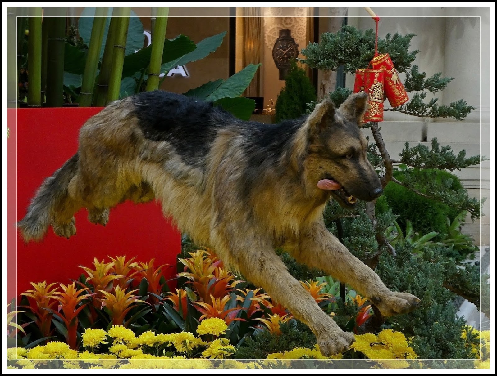
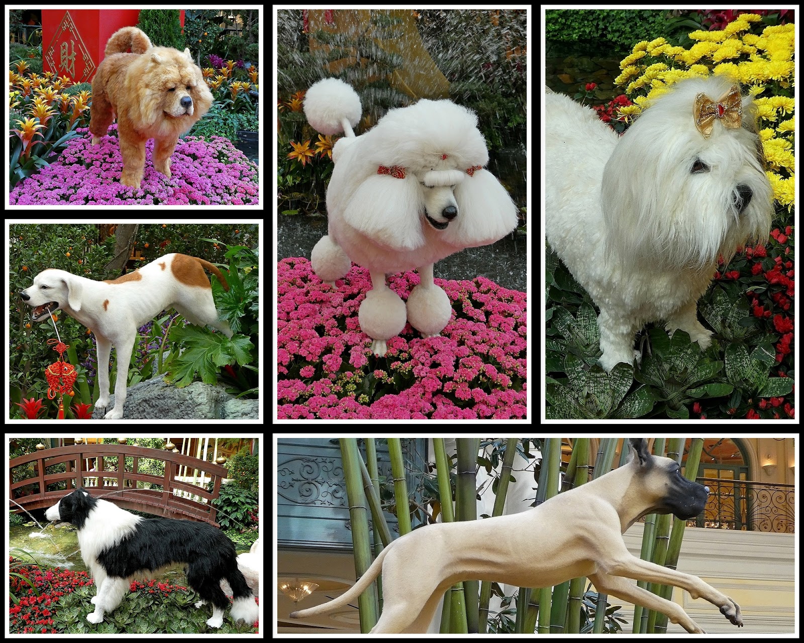
Bellagio’s Conservatory & Botanical Garden – Chinese New Year (2018)
{Click on an image to enlarge, then use the back button to return to this page}
This page last updated on 01/30/2018
 |
| (Fig. 01) |
The Chinese calendar runs in a 12-yearly cycle, with each year of the Chinese Zodiac in that cycle represented by a different animal. The dog is the eleventh sign of the Chinese Zodiac. This is your year if you were born in 1922, 1934, 1946, 1958, 1970, 1982, 1994, 2006, 2018, 2030, 2042. People born during the Year of the Dog (a symbol of loyalty and honesty) possess the best traits of human nature and are honest, friendly, faithful, loyal, smart, straightforward, venerable and have a strong sense of responsibility. On the negative side, they are likely to be self-righteous, cold, terribly stubborn, slippery, critical of others and not good at social activities. Note: Any of this sound familiar - this is my year.
 |
| (Fig. 02) |
The dog, representing loyalty and bravery, watches over two children as they play with lanterns and fireworks, joined by other dogs running and jumping through the West Garden.
 |
| (Fig. 03) |
 |
| (Fig. 04) |
 |
| (Fig. 05) |
 |
| (Fig. 06) |
 |
| (Fig. 07) |
 |
| (Fig 08) |
 |
| (Fig. 09) |
 |
| (Fig. 10) |
 |
| (Fig. 11) |
 |
| (Fig. 12) |
Subscribe to:
Posts (Atom)