 |
| (Fig. 01) |
|
 |
| (Fig. 02) Desert National Wildlife Range MAP |
|
|
| Early History: The area now known as the Desert NWR has been utilized by ancient people for thousands of years: first by Archaic people and then during the last several hundred years by the Southern Paiutes and others. These Native Americans traveled in small mobile bands while following the seasonal ripening of plants and the movements of animals. The evidence of these ancient people can be seen in numerous cultural resource sites such as agave roasting pits, caves and rock shelters, camps, rock art and ancient artifacts. Paiute Indians were living near the watering places in the late 1700's when Europeans first visited the region. These were Spanish pioneers searching for a route between settlements in present day New Mexico and California which later became known as the Spanish Trail. In the mid 1850's Mormon settlers moved into southern Nevada. Some settled in the area that is now near downtown Las Vegas. By the 1880's settlements in the Moapa Valley (east towards the Colorado River) were well established. Around the turn of the century, two wagon trails now known as the Alamo Road and the Mormon Well Road, refer to (Fig. 02), were developed as travel routes by pioneers in this region. These trails served early efforts at mining and ranching in this part of the state. |
|
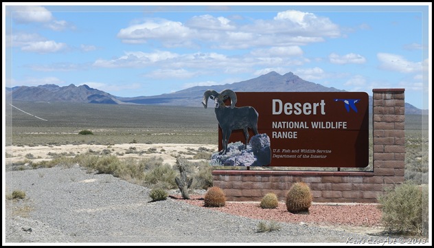
Desert National Wildlife Range (DNWR) History: The DNWR range (Fig. 01) was established on May 20, 1936 by President Franklin D. Roosevelt, for the expressed purpose of providing an area for the protection, enhancement and maintenance of the desert bighorn sheep. The 2.25 million acre Game Range, under the joint administration of the Service and Bureau of Land Management (BLM), included most of the lands within the current Refuge boundary, but stretched south to include portions of the Spring Mountains, including the area currently occupied by Red Rock Canyon National Conservation Area. To give you an idea of its size, (Fig. 02), it is twice as big as the state of Rhode Island and is the largest wildlife refuge south of Alaska.
Located in the southwest corner, Corn Creek was an old ranch site and stage coach stop used by early prospectors and cattlemen, as well as poachers and bootleggers. In 1939, the 320-acre ranch at Corn Creek was acquired from a private landowner under the authority of the Migratory Bird Conservation Act. This site became the administrative headquarters for the Game Range. Between 1970 and 1985, 440 acres in the vicinity of Corn Creek were purchased from a variety of private land owners under the authority of the Endangered Species Act and Refuge Recreation Act.
In October of 1940, approximately 846,000 acres of the Desert Game Range were reserved for the use of the War Department (Department of Defense [DOD]) as an aerial bombing and gunnery range (now known as the Nevada Test and Training Range [NTTR]) (Fig. 02). Even though the bombing impact areas of the NTTR are under the control of the DOD, the Service retained secondary jurisdiction over these lands. Public Land Order 4079, established the Desert National Wildlife Range under the sole administration of the Bureau of Sport Fisheries and Wildlife (now the Service), and also reduced the size of the refuge to 1,588,000 acres. Encompassing nearly 1.6 million acres, it still remains the largest national wildlife refuge in the continental 48 states and the largest protected area in Nevada.
The Desert NWR forms one of the largest intact blocks of desert bighorn sheep habitat remaining in the southwestern United States. Known as the Sheep Range, it contains six major mountain ranges with elevations from 2,400 feet to almost 10,000 feet. Rainfall amounts vary from 4 to 15 inches; the various elevations, have created amazingly diverse habitats suited to a wide variety of flora and fauna. Over 500 species of plants have been identified in plant communities or zones varying from saltbrush on the valley floors to ponderosa pine, white fir, and bristlecone pine at the highest elevations. The wide variety of vegetative communities in its intervening valleys provides ideal upland habitats for large mammals, birds, reptiles, and several sensitive species, such as the desert tortoise.
The Refuges' headquarters, known as Corn Creek Field Station, (Fig. 03), provides spring and pond habitat with wetland and riparian vegetation. The Refuge also contains two National Register Districts (Corn Creek Campsite and Sheep Mountain), which contain prehistoric and historic resources representative of past uses of the Refuge. Although only a small portion of the Refuge has been surveyed for archaeological resources, approximately 450 prehistoric sites and several historic sites have been recorded. The Refuge is also known to contain paleontological resources (fossils) dating back to the Pleistocene era (1.8 million to 10,000 years ago). A new visitor center was built to replace the old kiosk in 02/22/2014. Check it out here ... Corn Creek Station - DNWR - Trip Notes for 02/22/2014.
|
 |
| (Fig. 03) (Old kiosk) |
|
|
DNWR Overview: This refuge’s 2,300 square miles offers many opportunities for unique and solitary desert experiences. Birding, photography, primitive camping, picnicking, backpacking, and hiking are some of the non–wildlife-dependent recreational opportunities available on the Desert NWR. As a matter of fact, there are literally dozens of roads and hikes within the range, as evidenced by the following site … Hiking Around the Desert National Wildlife Refuge. Unfortunately, except for the 3.8 mile paved road leading to refuge’s headquarters at Corn Creek, all of its roads are dirt, with the majority requiring a high-clearance four-wheel drive vehicles, thereby limiting exploration to those with an appropriate vehicle. The public portion of the range is a vast amount of land that is classified as wilderness and is entirely wild and open to hiking. This is relatively high desert where, because the elevations here range from about 2,500 feet in the lowest valleys to 9,912 feet at Hayford Peak, the cooler temperatures make for rather pleasant activities when compared to those of the Las Vegas valley.
Because protecting the desert bighorn sheep and its habitat is one of the most important objectives of the range, the Service maintains and adds guzzlers, monitors springs, studies herd health, diet, predators, genetic diversity, and conducts yearly fall and spring helicopter surveys. Numerous other wildlife species such as mule deer, coyotes, badgers, bobcats, foxes, and an occasional mountain lion are the larger mammals sharing this habitat with the bighorn sheep. Over 260 species of birds have been identified on the Range. Examples are phainopepla, roadrunner, pinyon jay, house finch, loggerhead shrike, red-tailed hawk, and golden eagle. Wildlife-dependent recreational opportunities include wildlife observation, photography, and, at certain times of the year, hunting.
DNWR Access: After driving approximate 30 miles north of Las Vegas on US-95, you turn right and head east onto a 4-mile paved ravel road that leads to Corn Creek Visitor Station. From here, there are two main dirt roads that run through the range, Alamo Road and Mormon Well Road, both of which start at a t-intersection just east of Corn Creek Station (Fig. 04). The more traveled Mormon well road is a 47-mile long expedition through a desert basin known as Yucca Forest, filled with thousands of acres of yucca, Joshua trees, and creosote bush. After winding across this basin you begin to climb into a high desert landscape filled with junipers and pines. About 28 miles out you reach the Mormon Pass Campground and historic Mormon Well, located in a grove of Ponderosa pine. Alamo Road heads north from Corn Creek and provides access to a number of roads that climb into the western base of the Sheep Range, one of which, Hidden Forest Road, leads to a historic backcountry cabin where hikers can spend the night. |
|
 |
| (Fig. 04) Click to Enlarge |
09/06/2018 Trip Notes: On today's visit Jim Herring and I spent more than five hours driving my jeep across the entire range on Mormon Well Road. We made stops of all the interesting points of interest along the way and had a picnic lunch at the Mormon Pass Picnic Area. Click here for pictures and information on today's visit .... Mormon Well Road - DNWR.
04/21/2017 Trip Notes: Today, Jim Herring and Harvey Smith and I visited Corn Creek Station for a morning outing. When we go there we found out the Visitor Center is closed on Tuesdays and Wednesdays. We then decided to drive Glass Peak Road in search of Glass Spring and a guzzler at the end of Quail Spring Road. Click here for pictures and information ... Gass Peak Road - Trip Notes for 04/21/2017.
02/13/2014 Trip Notes: On today's visit I made stops at the new visitor's center at Corn Creek Station and to a location off Gass Peak Road for a hike to Fossil Ridge. Click here for pictures and information on today's visit ... Corn Creek Station (DNWR) and Fossil Ridge (North End) - DNWR.
03/01/2013 Trip Notes: Harvey Smith and I decided to spend the day hiking and exploring some of sites and trails off of Mormon Well Road (Fig. 04) inside the Desert National Wildlife Range. We made our first stop at Corn Creek, the refuge headquarters, located about 3.8 miles east from the turnoff on US-95. From there we headed further east to the junction of Alamo Road and Mormon Well Road. Our goal for today’s journey was a couple of hikes about 11 miles up Mormon Well Road. Use the links below to view each location.
|
 Corn Creek Station - DNWR: Corn Creek Station, is the main entrance/access to the Desert National Wildlife Range, an area of more than 1.5 million acres. It is a refreshing, green desert oasis located on the edge of a broad, flat valley at the foot of the Sheep Mountains. Several springs in the area provide water for Honey Mesquite, Cottonwood Trees, and wetland plant species. Corn Creek is a true bird magnet with more than 240 species having been recorded here. There are some really nice meandering trails which take you over and along the creek, several ponds, by some historic ranch buildings, and under shady trees. The trails around the Corn Creek field station are well maintained and quite easy. Corn Creek Station - DNWR: Corn Creek Station, is the main entrance/access to the Desert National Wildlife Range, an area of more than 1.5 million acres. It is a refreshing, green desert oasis located on the edge of a broad, flat valley at the foot of the Sheep Mountains. Several springs in the area provide water for Honey Mesquite, Cottonwood Trees, and wetland plant species. Corn Creek is a true bird magnet with more than 240 species having been recorded here. There are some really nice meandering trails which take you over and along the creek, several ponds, by some historic ranch buildings, and under shady trees. The trails around the Corn Creek field station are well maintained and quite easy. |
 Yucca Peak Fossil Beds: This is a moderately strenuous off-trail hike that runs up a wash, then up a hillside, and onto the top of a ridge with lots of Paleozoic fossils in the bedrock and in the surrounding rubble. The route is fairly short, only about 3/4 of a mile, making an elevation gain of only 400-500 feet, making it a nice desert hike during the short days of winter. Yucca Peak Fossil Beds: This is a moderately strenuous off-trail hike that runs up a wash, then up a hillside, and onto the top of a ridge with lots of Paleozoic fossils in the bedrock and in the surrounding rubble. The route is fairly short, only about 3/4 of a mile, making an elevation gain of only 400-500 feet, making it a nice desert hike during the short days of winter. |
 Yucca Peak: This is a fairly strenuous off-trail hike to the top of a limestone mountain offering many small limestone cliffs to climb or otherwise get around. Even though the hike is only about 2 miles in length, there is a nearly 2,000 foot elevation gain. From the road, the route runs east across several washes to the base of the mountain, where it then follows the eastern and southern ridges to the summit (7,180 ft). As I have yet to climb this peak, there is no link to a page. Yucca Peak: This is a fairly strenuous off-trail hike to the top of a limestone mountain offering many small limestone cliffs to climb or otherwise get around. Even though the hike is only about 2 miles in length, there is a nearly 2,000 foot elevation gain. From the road, the route runs east across several washes to the base of the mountain, where it then follows the eastern and southern ridges to the summit (7,180 ft). As I have yet to climb this peak, there is no link to a page.
|
 Fossil Ridge (North End): Fossil Ridge is roughly a four mile long ridge that boarders north side of Gass Peak Road. As far as I know, there is no specific trail that leads to the top of this ridge. From where we attacked its northern end, it is a moderately strenuous two mile off-trail hike that runs up and down a series of hills as it crosses the desert and then up a very rocky ridge that leads to the top of Fossil Ridge’s northern peak. Though I have yet had time to reach the top, it is rumored to have numerous Gastropod fossils along the top of the ridgeline. Fossil Ridge (North End): Fossil Ridge is roughly a four mile long ridge that boarders north side of Gass Peak Road. As far as I know, there is no specific trail that leads to the top of this ridge. From where we attacked its northern end, it is a moderately strenuous two mile off-trail hike that runs up and down a series of hills as it crosses the desert and then up a very rocky ridge that leads to the top of Fossil Ridge’s northern peak. Though I have yet had time to reach the top, it is rumored to have numerous Gastropod fossils along the top of the ridgeline. |


 Lakeshore Drive (Part I) - LV Bay Overlook to 33-Hole Overlook: This page provides pictures and descriptions of Las Vegas Bay Overlook, Rocky Point Overlook, Three Island Scenic Overlook and 33 Hole Overlook. Each of these stops provide views overlooking the Las Vegas River, Las Vegas Bay and Boulder Basin. The 33 Hole Overlook takes you out to what is known as Pitch Fork Cove, and has trails that lead you to the tip of a very large peninsula where many people go to fishing.

 Lakeshore Drive (Part II) - Long View Overlook to Sunset View Scenic Overlook: This section provides pictures and descriptions of Long View Overlook and Sunset View Scenic Overlook. These two stops offer some of the best landscape views of the lake and its surrounding mountains. If you head west across the road at Long View Overlook, you can hike a wash deep into the River Mountains. Both of these locations offer restroom facilities.
  Lakeshore Drive (Part III)- Boulder Beach to the Alan Bible Visitor Center: This section provides pictures and descriptions of Boulder Beach, Las Vegas Boat Harbor and Lake Mead Marina and the Alan Bible Visitor Center. The Boulder Beach location lets you dip your feet into the lake’s chilly waters. The boat harbor and marina provide the opportunity to feed the many ducks, birds and fish that hang around the area. You can also find food and restroom facilities here. The newly renovated visitor center is surrounded by an outside cactus garden, with walking trails, that is filled with desert flora and fauna. Inside are displays, movies and a gift shop with dozens of books on the southern Nevada desert.
 Yucca Peak: This is a fairly strenuous off-trail hike to the top of a limestone mountain offering many small limestone cliffs to climb or otherwise get around. Even though the hike is only about 2 miles in length, there is a nearly 2,000 foot elevation gain. From the road, the route runs east across several washes to the base of the mountain, where it then follows the eastern and southern ridges to the summit (7,180 ft). As I have yet to climb this peak, there is no link to a page.


