{Click on an image to enlarge, then use the back button to return to this page}
This page last updated on 06/15/2017
 |
| (Fig. 01) Raintree |
 |
| (Fig. 02) |
 |
| (Fig. 2A) |
05/26/2016 Trip Notes: Today, Blake Smith and I attempted to reach "Raintree" (Fig. 01), a Bristlecone Pine tree, estimated to be more than 3,000 years old. Reaching this tree on the North Loop Trail requires an extremely three plus mile hike with a steep elevation gain of more than 1,583 feet. The short of it is we didn't make it. Between the thin elevation air, our ages and being a little out of shape, we felt somewhat exhausted, and decided to exercise our better judgement and not try to go all the way. So, after hiking up greater than 900 feet and more than a mile and a quarter from the trailhead (Fig. 02), we reached the ridge called "Lookout" (Fig. 02A). After hiking about .2 miles past this point, we made a disappointing decision to abandon this goal. The good news is this was still a great hike. We experienced some outstanding views (Figs. 03-05) and the remains of a once large stand of Bristlecone Pines on an exposed 9,330 foot elevation ridge-line about 1.5 miles from the trailhead. Taken at about the 9,100 foot elevation, the picture in (Fig. 05) shows the road below and the parking area at the trailhead (left side of the picture). Though we heard the cacophony of dozens of birds in the trees that surrounded us on the way up and back, they were very elusive and hard to locate. I only got one sighting that lasted long enough to snap a picture (Fig. 06). (notes con't below)
 |
| (Fig. 03) |
 |
| (Fig. 04) |
 |
| (Fig. 05) |
 |
| (Fig. 06) |
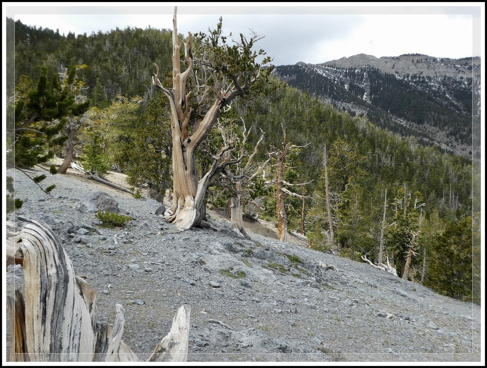
Trip Notes Continued: After dozens of trail switch-backs and some strenuous hiking, we finally reached a ridge-line about a mile from the trailhead and began seeing the remains of dozens of aging Bristlecone pines (Fig. 07). Even though some still showed signs of continued growth (Figs. 08 & 10), many were totally devoid of any visible vegetation (Fig. 09). To learn more about these ancient trees check out ...
Bristlecone Pines (Pinus longaeva). Roaming around and exploring the top of the ridge we found examples of lichen, mushrooms and moss (Fig. 11). The middle picture in (Fig. 11) is a Black Morel mushroom - click here for more information ...
Morels (Morchella spp). I also got some beautiful close-ups of tree details like knotholes, wood-grain and twisted stumps (Fig. 12). After hiking about a quarter mile beyond this ridge-line, we finally decided to return to this area, have lunch, and take a few more pictures before hiking the 1.5 mile return to the trailhead (Figs. 13-15). once we reached the trailhead we were surprised to find three wild horses walking up the road (Fig. 16). (Notes con't below)
 |
| (Fig. 07) |
 |
| (Fig. 08) |
 |
| (Fig. 09) |
 |
| (Fig. 10) |
 |
| (Fig. 11) |
 |
| (Fig. 12) |
 |
| (Fig. 13) |
 |
| (Fig. 14) |
 |
| (Fig. 15) |
 |
| (Fig. 16) |
 |
| (Fig. 17) |
Notes Continued: On our way home we noticed an area along side Kyle Canyon Road that was filled with spring blossoms. This section (Fig. 17) was filled with by far the most concentrated gathering of wildflower blossoms I've seen all spring. Because this was an area where the 2013 Carpenter Canyon Fire crossed the road, I think that the burned remains actually "rejuvenated" the soils. Actually, the first plant shown in the upper left corner of the college in (Fig. 17) was found all over the top of the Bristlecone ridge-line noted above. It is a Dwarf Phlox (Phlox condensata), a mat-forming perennial forb that grows in rocky areas between 6,500 and 13,000 feet. Next there are Mojave Pricklypoppy (Argemone corymbosa), Beard-tongue Penstemon, Desert Globemallow (Sphaeralcea ambigua), and I think what might be Notch-Leaved Phacelia (Phacelia crenulata).
 |
| (Fig. 18) |
The "Raintree" Name: The Bristlecone Pine is Nevada's state tree. These trees are the oldest living thing on Earth, with some specimens in Nevada dating more than 4,000 years old. Worldwide the name "raintree" is a common name for a variety of tree species. Generally, these types of trees have a huge, wide cover (up to a 100 feet) and grow to a height of 80 feet. It is a belief that the tree produces rain at night. The leaflets close up at night or when under heavy cloud cover, allowing rain to pass easily through the crown. The leaflets also close during the day when the sky was overcast, thus giving rise to the name, Rain Tree. This trait may contribute to the frequently observed fact that grass sometimes remains green under the trees in times of drought.
Clicking the picture-link below will open OneDrive in a new window and a folder containing 48 pictures taken of a trip hiking the North Loop Trail. To view the show, click on the first picture in the folder and you will get the following menu bar:
Clicking the "Play slide show" will play a fullscreen window of the slide show.
___________________________________________________
Note: Every attempt is made to provide accurate information, but occasionally depictions are inaccurate by error of mapping, navigation or cataloging. The information on this site is provided without any warranty, express or implied, and is for informational and historical purposes only.