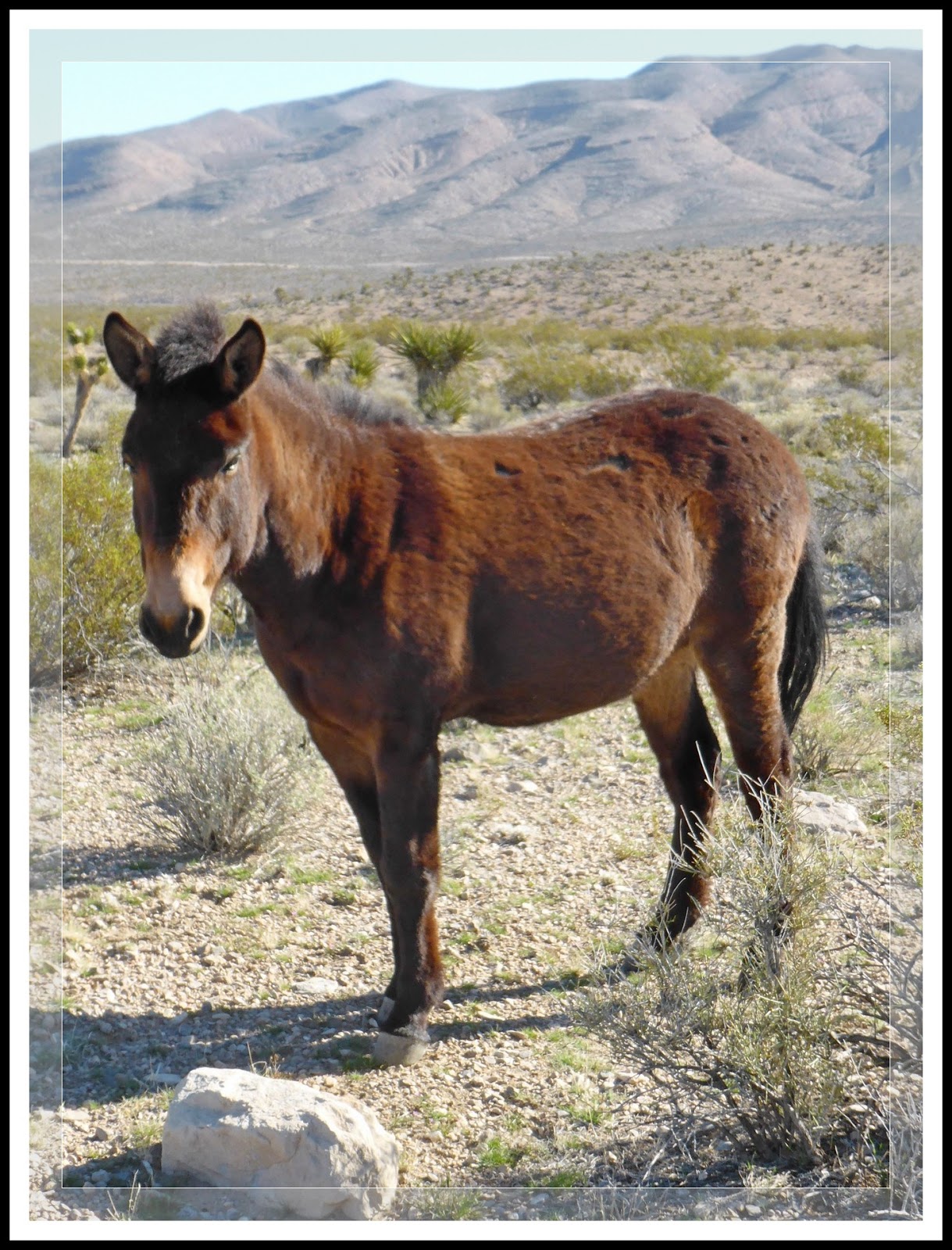
Tuesday

Death Valley National Park Flora - 03/09/2016 Trip Notes

 {Click on an image to enlarge, then use the back button to return to this page}
This page last updated on 06/15/2017
(Fig. 01)
03/09/2016 Trip Notes:  At one picture taking stop we made on the way into the park we found some Globe Mallow (Fig. 02) that I had not observed on my previous trip. As you can see from the two pictures in (Figs. 01 & 03), there were still many sprawling vistas of purple and yellow. Even though the picture in (Fig. 02) looks like just a blanket of yellow flowers, a closer inspection of this area revealed that it contain nearly a half dozen of smaller flowers growing closer to the ground. Each of the pictures found in (Figs. 04 thru 09) below were found by walking around this area. Though I had captured pictures for some of these flowers on my previous trip, there we several that I had missed. (con't below)

(Fig. 02)
Desert Globemallow (sphaeralcea abigua)

(Fig. 03)
Desert Gold (Geraea canescens)
(Fig. 04)
Golden Evening-Primose (Camissonia Brevipes)
(Fig.05)
Desert Five-Spot (Eremalche rotundifolia)
(Fig. 06)
Scented Cryptantha (Cryptantha utahensis)
(Fig. 07)
Brittlebush (Encelia farinosa)
(Fig. 08)
Rock Daisy (Perityle emoryi)
(Fig. 09)
Bearded Cryptantha (Cryptantha barbigera)


Trip Notes Continued: After reaching the site of the Ashford Mill ruins, I decided to walk down into a wash (Fig. 10) that I had not examined on my previous visit. In addition to the normal sunflowers, Desert Sabrina (Fig. 11), and Desert Five-Spots (Fig. 12), we found a Desert Iguana (Fig. 13) roaming around the base of a Creosote Bush [Creosote Bush (Larrea tridentata)]. In all my hiking, this is the only fourth time I have seen one of these. Even though he get moving around the bush, we were grateful that he didn't retreat into his burro, allowing us to capture some pictures (Fig. 14). After finding this guy we decided to have a picnic lunch inside the shade of one of the site's ruins (Fig. 15). As we headed home we found some pictures of Caltha-Leaf Phacella and Indigo Bush (Figs. 16 & 17) on the east side of the road going back toward Badwater Basin. Even though the blooms were not as good a two weeks before, it was still good enough that Jim had a good day and got some great pictures.
               
(Fig. 10)
(Fig. 11)
Desert Sand Verbena (Abronia villosa)
(Fig. 12)
Desert Five-Spot (Eremalche rotundifolia)
(Fig. 13)
(Fig. 14)
(Fig. 15)
(Fig. 16)
Phacelia calthifolia (calthaleaf phacelia or caltha-leaved phacelia)
(Fig. 17)
Indigo Bush (Psorothamnus fremontii)
Gravel Ghost (Atrichoseris platyphylla) (white) 

                               Click here to return to the previous page ...

Yellow Plug Site (Summary Page)

  {Click on an image to enlarge, then use the back button to return to this page}
This page last updated on 10/11/2017

Introduction: As I began to discover more and more rock art sites during my hikes over these past several years, I have become witness to far too many examples of where persons had seemed fit to deface them with graffiti and other examples of damage. Eventually I realized that the sharing of my hiking adventures could have the potential to increase public exposure, and thereby increasing the possibility for even more damage. As a result, I decided to preface each of my rock art pages with the following information to help educate visitors about the importance of these fragile cultural resources. Before scrolling down, I implore you to READ the following ... as well as the linked page providing guidelines for preserving rock art.


Here are a few simple guidelines you can follow that will help to preserve these unique and fragile cultural resources that are part of our heritage. Guidelines for Preserving Rock Art. If you would like to learn more about the Nevada Site Stewardship Program, go to my page ... Nevada Site Stewardship Program (NSSP).
    

03/18/2016 Trip Notes: Today's trip was my second visit to this site. So far, I have been unable to find any information about this location on the Internet. I initially learned about the location of this site, called "Yellow Plug", during a conversation with a local resident while having lunch in the Pioneer Saloon in Goodsprings. The full panel of glyphs run about 40 feet in length. At its northern end, there is a shady crevice in the rock that even contains some well aged pictographs. Starting from its southern most point, the pictures below (Figs. 04 thru 15) were taken from left to right towards its most northern point. Along the bottom edge of the panels, you will encounter grass, several colorful plants, cactus and a few dying trees (Figs.04).
                       
(Fig. 01)
(Fig. 02)
(Fig. 03)
(Fig. 04)
(Fig. 05)
Could the symbol near the center be that of a human or a lizard
(Fig. 06)
I have read in the past that these types of symbols could be shields representing a tribe

(Fig. 07)
(Fig. 08)
(Fig. 09)
(Fig. 10)
Is the symbol on the middle right representative of a bighorn sheep or antler
(Fig. 11)
Could the pictograph symbols in the upper left be three people?
(Fig. 12)
(Fig. 13)
This could be another symbol to denote a tribes' 'war shield' 

(Fig. 14)
In the center there is another possible human or lizard symbol
(Fig. 15)


Ash Spring @ Calico Basin - 03/09/2016 Trip Notes

 {Click on an image to enlarge, then use the back button to return to this page}
This page last updated on 06/15/2017
(Fig. 01)
(Fig. 02)
03/08/2016 Trip Notes: After a failed attempt to hike Sloan Canyon, due to a road closure, Harvey Smith, Blake Smith, Robert Croke and myself decided to go out to Calico Basin. From the Ash Spring trailhead at the parking lot at the end of Sandstone Drive, we headed west, then northwest up the desert hillside to the base of Dragon Peak. We hiked up more than 350 feet to an elevation of nearly 3,600 feet. See the green arrow in the upper right of the picture in (Fig. 03). We wanted to hike to the top of the ridge-line, the second green arrow on the horizon, but realized that we would have had to hike up yet another difficult, rocky strewn (Fig. 04) elevation of nearly four hundred additional feet and, an additional distance of more than a half mile. We decided that it was more difficult than we had originally envisioned. Even though it was still too early to see any of the spring blooms we envisioned on our previous trip here during April of last year (Click the link at the bottom of the page) , we did find the occasional rock daisy (Fig. 05). From here we followed the trail that led us down to the spring at the base of this steep steep hill. The view in the picture seen in (Fig. 01), a little more than halfway down, provided a nice view of the town and Calico Basin. When we finally reached the bottom most point near the source of Ash Spring we ended up in the bottom of a wash. The view in (Fig. 06) was a shot looking northwest up the wash. (con't below)

(Fig. 03)

(Fig. 04)
(Fig. 05)
(Fig. 06)
Trip notes continued: Looking southwest we were confronted with two very large boulders. Behind these boulders there was a small spring pool where water was slowly seeping out of the surrounding rocks (Fig. 07). After squeezing through a small opening in the rocks, we found a nice, quiet area where we all enjoyed a nice picnic lunch (Fig. 08). The quiet solitude here was absolutely wonderful. From here we hiked east across the open desert meadow between the Ash Spring creek and the base of the Calico mountains (Fig. 09). In the heavily eroded creek along the north side (Fig. 10), there were several areas where spring's water was flowing along the surface (Fig. 11). Climbing south we headed up out of the meadow to a small plateau where the local residents had created a very large geoglyph. Both Bob and I snapped pictures of Harvey and Blake standing in the center of the geoglyph (Fig. 12). From all I can gather about the cement foundations and septic tank adjacent to the geoglyph area at the end of the road is all that remains of a failed house building attempt (Fig. 13). It's too bad, it would have had the best view of Ash Canyon and Ash Spring in the entire basin (Fig. 14). I would like to like my hiking partner, Bob Croke for providing pictures (Figs.  01, 02, 10 & 12).
                                    
(Fig. 07)
(Fig. 08)
(Fig. 09)
(Fig. 10)
(Fig. 11)
(Fig. 12)
(Fig. 13)

(Fig. 14)
                                 Return to the [Calico Basin Summary Page]


Mule (Equus Mule)


(Fig. 01)
Picture Notes: The picture of the Mule in (Fig. 01) was taken on 03/18/2016 while hiking around Goodsprings Valley behind the town of Goodsprings, Nevada.  The pictures of wild Burro in (Fig. 02) was captured on a drive through Red Rock Canyon Park. For more on these Burros go to ... Wild Burro (Donkey) - (Equus - asinus).


Description: Because Mules do not constitute a species, there is no scientific name for mules as a species. The reason mules are not considered a species is because mules do not reproduce - they are hybrids, the offspring of a male donkey (called a jack) and a female horse (called a mare). Mules are almost always sterile (except that, on rare occasions, a female mule can be fertile).
Mules inherit desirable qualities from both donkeys and horses; from the horse they inherit strength and stamina, and like donkeys, mules are generally patient, sure-footed, intelligent and have an even temper. Donkeys have long ears, a short thick head, a short mane, thin limbs and narrow hooves (Fig. 02). Mules share these characteristics with donkeys but they are larger and taller than donkeys. The physical characteristics that mules share with horses include shape of the body, a uniform coat, and teeth (Fig. 01). The hooves of a mule are harder than those of a horse. The coat of a mule is usually brown (sorrel). Mules have longer ears than horses but usually somewhat smaller than donkey.

Mules have several advantages. Mules have tougher and less sensitive skin than horses. They can live as high as 50 years when compared the the horse's 30-ish years. They need less food, pound for pound, than horses due to a much more efficient digestive tract. Pound for pound mules are also stronger than horses and have a better stamina and agility. Because they are typically much larger than donkeys, they can carry a greater weight. Mules don't spook as easy as horses do and have a strong "self preservation" sense making them a better companion in a fight with wild animals. Finally, mules endure heat and lack of water much better than horses, and are built more for desert life.

Major differences between a wild burro (Donkey) (Equuis asinus) and a Mule: The main difference between a donkey, mule, and a horse is genetics. Beyond the genetic difference, you can easily tell the difference between a donkey and a mule by a few different physical markers. The easiest thing to spot is that mules are usually larger than donkeys (often significantly so), much more closely resembling a horse in size. Another easy difference to spot is that, in the summer, a mule’s coat tends to more closely resemble a horse’s, rather than the longer, coarse hairs of a donkey. However, in winter mules tend to develop coats that more closely resemble a donkey. Besides physical and genetic differences between a mule and a donkey, you can also tell the difference just by hearing them make noises. Donkeys make a very distinctive hee-haw type sound. Mules make a sound that is something of a cross between a horse’s whinny and the donkey’s hee-haw, often starting as a whinny and melding into a hee-haw.